The need to classify the network of city streets and roads arose in connection with the need to ensure the movement of all types of urban ground transport within the city. The purpose of the classification is to divide traffic into homogeneous traffic flows in accordance with the functional purpose of the streets.
To increase the capacity of city streets and ensure clear organization of traffic, it is necessary to unify the rolling stock and make it more homogeneous. This makes it possible to distribute transportation along individual highways of the city and according to the degree of impact of rolling stock on the environment (noise, vibration, air pollution), and carry out these transportations taking into account the functional zoning of the city.
Currently, there is only a functional classification of city streets, dividing all city streets according to their purpose, but not according to technical indicators. This is explained by the fact that the street network is included in the master plan of the city with an orientation towards a very distant future (50 - 100 years) and for the development of this network the territory is reserved along the boundaries of which urban development is located. The boundary separating the street from the building area, beyond which buildings should not extend, is called red lines. All street elements that support the movement of pedestrians and vehicles must be located within the red lines.
Placing sidewalks, roadways and other street elements within the allocated areas that ensure the passage of future traffic intensity is more important than standardizing the technical parameters of these streets (Table 1.3).
The accepted classification establishes the minimum number of elements of the transverse profile of the street and their main dimensions. An increase in these sizes is possible with a feasibility study, the basis of which is calculations to assess street capacity, traffic safety and transport losses. Such calculations are mandatory when designing city streets and virtually eliminate the uncertainty associated with the lack of technical classification. The same street category may, depending on the expected intensity
|
Main design parameters |
||
|
Expressway highways |
Transport connections between industrial and planning areas in the largest and largest cities, between the city and the suburban area, deep entry of highways into the city, connections with airports, public recreation areas. Intersections with streets and roads at different levels. |
The predominant types of transport are public express passenger and passenger cars. Local traffic, as well as tram and freight traffic, are excluded |
|
Expressways are designed according to the standards of motor roads of the first technical category. |
Estimated speed in a densely populated part of the city is 80 km/h; outside the central part of the city 100 km/h; in the suburban part of the city 120 km/h. The road is separated from the city street network. |
Number of lanes 4-8, lane width 3.75 m |
|
Main roads of regulated traffic |
Transport connections between city districts; in certain sections and directions there is a road predominantly for freight traffic carried out outside residential buildings, exits to external roads. |
Design speed 100 km/h, number of traffic lanes 4-8, lane width 3.5-3.75 m, longitudinal slopes up to 40%; medians, local or side roads. Curve radii: in plan 500 m; in the longitudinal profile convex more than 5000 m, concave more than 1000 m |
Design speed 80 km/h, number of traffic lanes 4-8, lane width 3.5 m, longitudinal slopes up to 50%; medians, local or side roads. Curve radii: in plan 400 m; in the longitudinal profile convex more than 3000 m, concave - more than 1000 m
|
Continuation of the table. 1.3 |
Main design parameters |
|
|
Functional purpose of streets |
b) regional significance |
Transport connections within the planning areas, with industrial enterprises, public centers and places of mass recreation and sports, as well as main streets at one level. Truck traffic is allowed |
|
Design speed 60 km/h, number of traffic lanes 2-4, radii of curves: in plan more than 250 m, in the longitudinal profile convex - more than 2500 m, concave more than 1000 m. Longitudinal slopes up to 60%. The distance between stopping points of passenger transport is no more than 600 m | ||
|
Local streets and roads: |
a) in residential buildings |
Transport (without passing the flow of trucks and public transport) and pedestrian connections in residential areas, exits to main streets and controlled traffic roads |
|
Design speed 40 km/h, number of traffic lanes 2-3, lane width 3.0 m, longitudinal slopes up to 70%o, sidewalks more than 1.5 m wide |
b) industrial-warehouse c) pedestrian |
Transport connections and passage of mainly trucks within the area, access to main city streets and roads. Intersections on the same level. Pedestrian connections with places of employment, institutions and service enterprises, including within public centers, recreational areas and public transport stops Design speed 50 km/h, number of lanes 2-4, lane width 3.5 m, longitudinal slopes up to 70% 0 |
The width of one pedestrian lane is 1.0 m, the width of the entire street or road - according to calculation, the greatest longitudinal slope is 40%o
The main transportation of passengers and goods in cities is carried out on main streets. It is these streets that determine the type of road network of the city. The number of main streets and their length are determined by the expected level of motorization of the city. For domestic cities, this level is accepted as 180 - 220 cars. per 1000 inhabitants. Smaller numbers refer to the largest and largest cities, larger ones to medium-sized cities and towns. For this level of motorization, the density of the main road network, defined as the ratio of the length of main streets to the area of the district, should be 2.2 - 2.4 km/km 2 of the city territory. This density does not have to be uniform throughout the city. In the central part of the city there is a dense
The number of main streets should be increased to 3.0 3.5 km/km 2 , in peripheral areas with residential buildings - to 2.0 2.5 km/km 2 , in industrial areas - reduced to 1.5 - 2.0 km /km 2, and, in forested areas - up to 0.5 - 1.0 km/km 2.
The density of the local street network in inter-highway areas can reach 2 km/km 2 . It should be taken into account that the placement and storage of personal cars are assumed to be on the roadway of the local street network. The standards for the design of residential areas provide for the placement on the territory of microdistricts of at least 70 % cars of citizens living in this microdistrict, taking into account the estimated level of motorization. Car storage areas in neighborhoods must accommodate at least 25% of passenger cars.
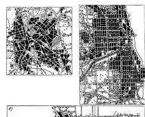
Streets and roads form a network of surface communication routes on the city plan. Based on its outline, it can be attributed, with more or less significant assumptions, to one of the fundamental diagrams of the city’s road network. Such patterns are free, not containing a clear geometric pattern, rectangular, rectangular-diagonal and radial-ring.
Free schemes streets are typical for old southern cities. The entire network consists of narrow, curved streets with a variable width of the roadway, often excluding the movement of cars in two directions (Fig. 1.9, A). Reconstruction of such a street network, as a rule, is associated with the destruction of existing buildings. For modern cities, this scheme is unsuitable and can only be left in protected parts of the city.
Rectangular diagram It is very widespread and is characteristic mainly of young cities or old (relatively) ones, but built according to a single plan. Such cities include Leningrad (central part), Krasnodar, Alma-Ata. The advantages of a rectangular scheme are the absence of a clearly defined central core and the possibility of uniform distribution of traffic flows throughout the city (Fig. 1.9, b). The disadvantages of this scheme are a large number of heavily loaded intersections, which complicate the organization of traffic and increase transport losses, and large overruns of cars in directions that do not coincide with the directions of the streets.
The adaptability of the street network to the requirements of modern urban traffic is assessed by the coefficient of non-straightness - the ratio of the actual length of the path between two points to the length of the overhead line. For a rectangular street pattern, this coefficient has the greatest value - 1.4-1.5. This means that in cities with such a street layout, urban transport for the transportation of passengers and goods makes overruns by 40 - 50% With the same traffic volumes, traffic intensity on streets of such cities with all the ensuing consequences (fuel consumption, environmental pollution, increased av
speed, congestion of streets with traffic) is 25 - 40% higher than in cities with radial-ring schemes.
Rectangular-diagonal pattern streets is a development of the rectangular scheme (Fig. 1.9, V). It includes diagonal and chord streets, made through existing buildings in the most congested directions. The non-straightness coefficient for such schemes is 1.2-1.3.
This scheme somewhat improves the transport characteristics of the city's street network, but creates new problems: crossing the city diagonally causes the appearance of complex intersections with five and six merging streets. At low traffic intensity (in total on all streets less than 1,500 vehicles per hour), a roundabout scheme can be used to interchange them; at high traffic levels, traffic interchanges on two and three levels can be used.
Radial-ring scheme street network is typical for the largest and largest cities and contains two fundamentally different types of highways - radial and ring (Fig. 1.9, G).
Radial highways are most often a continuation of highways and serve to deeply introduce traffic flows into the city, to connect the city center with the periphery and individual areas with each other. Ring highways are, first of all, distribution highways that connect radial ones and ensure the transfer of traffic flows from one radial highway to another. They also serve for transport links between individual areas located in the same zone of the city.
An example of such a layout is Moscow. The layout of its street network has evolved historically. The core of this network was the Kremlin. As the city developed as the capital of the Russian state, it was surrounded by urban buildings and defensive structures - earthen ramparts and fortress walls. These structures determined the emergence of ring highways. Currently, the number of radial highways has been increased to 20, and ring highways to 3. In the master plan for the development of Moscow, it is planned to increase the number of ring highways to 4, and to improve transport connections between the outer regions of the city, where residential and forested areas of the city are now being created, 4 will be built chord highways belonging to the category of expressways.
The radial-ring scheme of the city's road network does not require the presence of completely closed rings. It is important to ensure the movement of traffic flows from one radial highway to another in the shortest direction - tangential. Individual chords can be located in this direction. It is desirable that they overlap each other and provide communication between all radial highways. The closer to the city center, the greater the need for completely closed rings. On the periphery of the city, the need for transverse transport links is dictated mainly by the volume and direction of freight traffic.
The radial-ring scheme of the street network has the lowest coefficient of non-straightness - 1.05 - 1.1.

 Rice. 1.9. Schemes of the city street network:
A- free; b- rectangular; V- rectangular-diagonal; G- radial-ring
In their pure form, all the considered street network schemes are rare in modern large cities. As the city and its transport system develop, the street layout increasingly takes the form of first a radial scheme, and then, after the construction of bypass roads along the city boundaries and streets encircling the city center, a radial-circular one. Within one district, a rectangular street pattern is most often maintained.
Control questions.
What indicator is used to determine the size of a city?
What functional zones are distinguished on the territory of modern cities? What are the boundaries of these zones?
What schemes exist for connecting the city with external roads?
4. How does the layout of the city’s road network affect the load and capacity of the streets?
5. On what basis is the modern classification of the city’s road network based? In determining which street parameters is the estimated traffic speed used?
Volgograd State University of Architecture and Civil Engineering
Department of Energy and Chemical Chemistry
Abstract on the topic
"Types of urban planning structures"
Developed Art. gr. GSH 1-10
Frolova S.V.
Checked Zurabova I.V.
Volgograd 2013
Introduction
1.Radial structure of the city 6 pages
2.Radial-ring structure of the city page 9
3. Fan structure of the city 12 pages
4. Rectangular city structure 14 pages
5.Linear structure of the city 16 pages
6. Combined city structure 18 pages
Conclusion 21 pages
List of used literature 22 pages
2-
Introduction
A city is a territory that differs from the surrounding countryside in its high population density, compact development and complex architectural and planning structure.
A city is a living environment created by man, necessary for his diverse activities.
Modern cities are divided into:
- small (up to 50 thousand inhabitants), for example Dubovka;
-medium (50-100 thousand) – Mikhailovka;
-large (100-250 thousand) – Volzhsky;
-large (250-500 thousand) – Tambov;
-the largest (500 thousand - 1 million) - Volgograd;
- millionaire cities (over 1 million inhabitants).
In the 1980s, there were about 220 millionaire cities in the world.
Many large cities have satellite cities. Often cities and satellite cities combine to form agglomerations, which can be combined into megalopolises.
Classification of urban settlements can be carried out on many grounds, the main of which are size (population) and functions. Moreover, in each urban settlement there are city-serving functions (types of activities and industries whose products are intended for the city population - internal transport, baking industry, etc.) and city-forming functions, which have an external significance relative to the settlement. New cities and urban settlements are emerging due to the need of the country or its individual parts for certain city-forming activities. And urban settlements are classified according to city-forming functions.
3-
City-forming functions can be divided into two groups - central and special. The central functions are to provide various services to the population and economy of the adjacent territories. Urban settlements - central places form a fairly strict hierarchy within the country. At the top level of this hierarchy is the capital Moscow, serving the entire territory of the country. The next level is formed by cities - the largest centers of economic regions (Novosibirsk, Yekaterinburg, etc.). The territories of the constituent entities of the Russian Federation are served by regional centers (Pskov, Orel, Astrakhan, etc.). within each region, it is usually possible to distinguish a level of inter-district centers serving several lower administrative districts (for example, Orsk and Buzuluk in the Orenburg region). The next level is formed by settlements - regional centers (for example, Vyborg, Priozersk and others in the Leningrad region). The lowest level of the hierarchy is formed by settlements - intra-district centers that serve part of the administrative district (Aprelevka and Vereya in the Naro-Fominsk district of the Moscow region).
Special functions are often performed by industry centers throughout the country. Russia has the largest number of urban settlements - industrial centers (Magnitogorsk, Novokuznetsk, Komsomolsk-on-Amur, etc.). The most prominent representatives of transport centers are large seaports (Novorossiysk, Nakhodka). Relatively rare in our country are scientific centers (Obninsk in the Kaluga region, Dubna in the Moscow region, etc.), tourist centers (Suzdalvo in the Vladimir region) and resort centers (Sochi in the Krasnodar region, Pyatigorsk in the Stavropol region, etc.).
In terms of the degree of urbanization, the regions of the Russian Federation differ significantly both at the level of large economic regions and at the level of administrative-territorial entities.
4-
Urbanization is considered as a process of increasing the role of cities in the development of society, causing changes in the social and demographic structure of society, culture, lifestyle and concentration of forms of communication between people. Modern urbanization has significantly changed the course of settlement development. The process of urban consolidation is intensifying, which is accompanied by their rapid spatial expansion and dispersal of production and population into adjacent territories. The importance of enlarged cities as centers of economic and cultural influence on adjacent settlements is increasing. The big city turns into a vast urbanized area, in which it begins to play the role of the main center. An urban agglomeration is being formed - one of the qualitatively new forms of modern urban settlement.
5-
1.Radial system
The radial system in its pure form is not currently used, because it is very unfavorable due to its low throughput, limited by the throughput of its central point, at which all central streets converge. In addition, the radial system has a very high straightness coefficient in communications between different points of the city. The radial planning system in terms of its throughput is the least favorable due to the fact that all movement, in whatever direction from one radius to another it is carried out, passes through the central point at which all radial directions intersect. It is easy to see that the more radial directions converge at a central point, the less time it takes to move through the central intersection at each radius and, therefore, the less capacity it has. As a result, this central intersection point limits the capacity of the entire system.
The radial planning system is characteristic of the old cities of Central Asia, in which all roads coming from the surrounding areas converged on the city bazaar, centrally located in the city.
In the process of development of the cities of the Soviet Central Asian republics, the radial systems of highways were reconstructed with the creation of additional highways, unloading the urban center and reducing the coefficient of non-straightness when traveling from points located on different radial directions.
Radial system of Kharkov (Fig. 1)
Radial system of Nizhny Novgorod (Fig. 2)
Radial system of Uglich (Fig. 3)
8-
2.Radial-ring system
The radial-ring (concentric) system contains two fundamentally different types of highways - radial and ring. Radial highways serve to connect the city center with peripheral areas, and ring streets connect radial streets and ensure the transfer of traffic flows from one radial direction to another. This layout allows the development to be harmoniously located around the center, where the main public and business facilities are concentrated. With this layout you can easily get to the city center. The advantage of the radial-ring scheme is the compact shape of the plan, in which the natural environment of the city is least disturbed.
However, the full benefits of this scheme can only be realized in smaller cities. As the territory increases, the central part of the city experiences functional overload and is cut off from the natural environment, and peripheral areas find themselves at a considerable distance from the center.
A variation of the radial-ring layout is the “star” layout. In this case, the development is located in non-concentric strips around the city center, but is concentrated along the radial highways; in this case, arrays of greenery can be placed between the rays of the “star”. In this case, there is a good connection between the outskirts and the center. However, with such a scheme, connections between peripheral regions with each other are difficult. The star-shaped scheme requires attention to the problem of the development of the center and the increase in traffic intensity within its boundaries.
An example of a radial-ring system is the city of Moscow (Fig. 4). Along with Moscow, classic examples of a radial-ring
layouts are represented by cities such as Paris (Fig. 5).
It is less pronounced in Berlin (Fig. 6) and Brussels (Fig. 7).
(Fig.5)
-10-
Fig.7
-11-
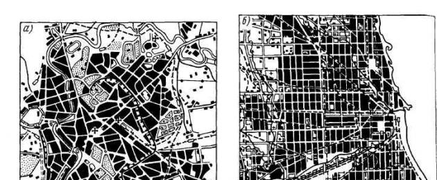
3.Fan (beam) system
Beam (fan) system - found mainly in the central parts of large cities in combination with other systems. In this case, the indicators for the coefficient of non-straightness and capacity are determined depending on the properties of those simple geometric systems from which the general planning system of the city was formed.
Examples are the city of Kostroma (Fig. 8), St. Petersburg (Fig. 9), the capital of Udmurtia, Glazov (Fig. 10).
Fig.10
-13-
4.Chess system
The checkerboard (rectangular) system, in which streets intersect at an angle of 90°, assumes a relatively uniform development of the territory. This type of planning structure has been widely used at all times. The advantage of the chess structure is the possibility of uniform distribution of traffic flows. With this layout, it is easy to demarcate areas.
However, a large number of street crossings increases vehicle mileage and lengthens trips. The checkerboard pattern makes it difficult to form a clearly defined central core and system of centers of residential areas of the city.
The positive properties of the rectangular system include the division of the urban area into rectangular blocks convenient for development. This system is favorable in terms of its throughput due to the fact that at each intersection point of this system only two directions intersect.
The rectangular system is unfavorable in terms of the weighted average non-straightness coefficient, reaching a value of 1.27. Also, the disadvantages include the monotony of the layout.
Examples are cities such as Philadelphia (Fig. 11), Odessa (Fig. 12), Rostov-on-Don (Fig. 13).
Rice. eleven
-14-
Fig.13
-15-
5. Linear system
The linear (ribbon) layout is a kind of checkerboard layout, strongly elongated in one direction. Objects in the central part of the city in this case are located along the main highway or along several parallel highways. The linear layout ensures proximity to the natural environment and main transport routes. This layout allows for convenient transport links, reducing travel time. However, as the city grows and the development zone lengthens, a significant part of the territories finds itself at too great a distance from the centers of various ranks. In addition, the distances between individual parts of the city are increasing significantly.
Examples are the city of Taishet. (Fig. 14), Volgograd (Fig. 15), Arkhangelsk (Fig. 16)
Fig.16
6.Combined system
Combined system (Fig. 17) - combines the features of simple systems and their components.
For example, the layout of St. Petersburg, built in its central part on three radial highways converging to the Admiralty building, has a clearly defined rectangular system in a number of districts of the city. Odessa has a rectangular layout, consisting of separate parts, the network of highways of which has a different direction in relation to local conditions.
Examples are St. Petersburg, Tashkent (Fig. 18), Odessa (Fig. 19).
20-
Conclusion
The search for a planning solution for the city and its transport organization in the form of a system of main streets and roads and a public transport network is carried out by conducting a comprehensive comparison of master plan options for a number of planning, compositional, transport and economic indicators, taking into account the city’s place in the settlement system. In this case, the technical and economic indicators of the network, traffic safety conditions, convenience and comfort of traffic and pedestrians are taken into account.
Transport connections should provide the ability to travel along the shortest routes between destinations, and the layout of the street grid should be simple, without complex nodes and intersections.
21-
Bibliography:
E.S. Kositsina, N.V. Korosteleva, I.V. Zurabova. “Planning, development and reconstruction of populated areas”, Textbook of VolgGASU, 2011. Pages 40-44
G.M. Barsukov. “Design of a city, microdistrict.” Textbook VolgGASU, 2009. pp.74-78
E.S. Kositsina, N.V. Korosteleva, I.V. Zurabova. Guidelines for course work in the discipline “Planning, development and reconstruction of populated areas.” 2011 Page 4
http://www.coolreferat.com (8.09.13)
http://www.2fj.ru/istoriya/skladyvanie_radialno-kolcevoj_ planirovki.php (8.09.13)
http://www.barviha-live.ru/zhilye-rajony-goroda/29.html (8.09.13)
http://images.yandex.ru (8.09.13)
URBAN PLANNING, theory and practice of urban planning and development; the field of architecture and construction, which comprehensively solves functional-practical (economic, demographic, construction-technical, sanitary-hygienic) and aesthetic (architectural-art) problems. The goals of urban planning are to create favorable conditions for the population to live, the functioning of production facilities, science, culture, public utilities, as well as the formation and preservation of an environmentally friendly and aesthetically meaningful urban environment.
The city is the largest and most complex object of architectural and technical design, representing not only an architectural ensemble, but above all a complex, developing spatial system, the parameters of which are constantly changing. Traditionally, urban planning was considered as an element of architectural activity, starting with classical treatises on architecture (Vitruvius, L.B. Alberti, V. Scamozzi, etc.), an indispensable part of which were chapters devoted to urban planning. Modern urban planning is understood as a complex activity in which architecture is an integral part on an equal basis with the block of social, technical and management disciplines. The methods and content of urban planning are influenced by the forms and features of urbanization, the physical growth of cities and agglomerations, the properties of their development as complex dynamic systems, the fundamentals of legal regulation of real estate, the tasks and methods of managing urban development. In the 20th century, urban planning science became a separate field of knowledge. Along with architectural disciplines (planning and development of populated areas, regional planning, landscape architecture, design of the urban environment, etc.), it includes a number of industry disciplines (economics of urban construction, water supply, sanitation, energy supply, district heating, organization of internal and external transport, engineering preparation of urban territories, their improvement and landscaping, construction of underground engineering networks, protection of architectural monuments and urban landscapes, etc.).
The planning and development of cities, their architectural and artistic appearance take shape gradually, as a result of long-term collective work of architects, engineers and builders. Therefore, planned urban planning requires creative continuity and urban planning discipline in the implementation of general architectural and engineering plans laid down in master plans for urban development and development projects for individual urban areas. The leading role in urban planning belongs to the chief architects of the city, who exercise creative, organizational and technical management of their planning and development.
 In established cities, urban planning solves two mutually exclusive problems - preserving the historical appearance of the city and its comprehensive reconstruction. This means not only the modernization of the housing stock, water supply and sewerage networks, but also the construction of new structures in the current development environment, including transport interchanges and underground parking lots, repurposing or moving sanitary-poor and outdated enterprises outside the city limits, and improvement work and so on. Indicators of urban improvement are their ecology, the degree of illumination, landscaping, the level of transport services for the population, the provision of energy, heat and water supply, sewerage, etc. Improvement activities can be conditionally divided into 2 stages: engineering preparation of the territory for residential development and work, produced at the operational stage. Landscaping of residential areas involves the construction of playgrounds for various purposes (children's, sports, parking, etc.), the arrangement of gardens and parks, and the construction of compositions with small architectural forms. An important part of landscaping is the cleaning of populated areas, including work on collecting, transporting and recycling waste; summer and winter cleaning of courtyards, streets and squares using municipal vehicles. Improvement activities are carried out by public utility enterprises that ensure the functioning of utility networks (pipelines for heating, sewerage, water supply, gas supply systems), thermal power plants, gas substations, waste treatment plants, wastewater treatment plants, transport, etc., as well as carry out repairs, reconstruction and operation of residential buildings. and public buildings, roads and sidewalks, bridges and tunnels; They are responsible for measures to combat gas pollution, noise, and the like.
The unifying significance in the structure of the city is the formation of a unified system of main streets and city roads, the mutual consistency of the architectural and planning organization and the city’s transport system. The system of main streets (the framework of the entire transport and planning organization of the city) provides connections with other cities and suburbs. The advent of the automobile made many suburban areas accessible every day and contributed to the rapid growth of cities. In modern urban planning, the time factor is becoming increasingly important. The progressiveness of the settlement system, the quality of planning and development of cities is determined, in particular, by the branching of the network and the speed of urban transport. Existing sanitary and hygienic rules regulate the time spent on traveling to work depending on the population of the city. So, these costs for cities (according to 2005 standards) with a population of 2 million people should not exceed 45 minutes, with a population of 1 million - 40 minutes, 500 thousand - 37 minutes, 100 thousand or less - 30 minutes. To ensure safe, fast and convenient city traffic, new streets are being laid and old streets are being reconstructed, high-speed city highways of continuous traffic are being built, and the movement and parking of individual vehicles on central streets and squares is being limited.
The material capital of cities (buildings, engineering structures) is calculated for a technical depreciation period of about 80-100 years, but often these buildings and structures are operated for longer periods. The city's backbone network, designed only for modern urban transport flows, may turn out to be unacceptable for future, significantly larger flows and new types of transport. The established size of the urban area and the capacity of engineering structures may be insufficient for the long-term development of the city. Therefore, a particularly important problem in urban planning has become the development of scientifically based long-term forecasts for the development of both individual cities and urban planning as a whole. When planning and developing cities, the achievements of social and scientific and technological progress must be taken into account, as well as the continuity of design stages, without which the urban landscape disintegrates into poorly connected elements.
With different models of urban planning management, the content and nature of planning and development projects differ. In countries with traditions of centralized management of urban planning, planning and development projects determine a set of architectural solutions and regulatory parameters (compositional solution, zoning, density and types of development, etc.). Under the liberal model, the project sets a minimum of urban planning conditions, while greater freedom is given to developers and investors. In developed countries, as a rule, the development and implementation of urban planning projects is based on officially adopted urban planning norms and rules. In Russia, this is a special chapter of the Construction Norms and Rules (SNiP) for the planning and development of populated areas, including rural ones, as well as for regional planning. In urban planning in many countries, computer technology is widely used (information support - data banks, solving design problems in dialogue with a computer, computer graphics). In Russia there is a network of specialized institutes for urban planning (NIIPI of the General Plan of the City of Moscow, Giprogor, TsNIIP of Urban Planning, etc.) and for urban development. The Department of Urban Planning operates within the Russian Academy of Architecture and Construction Sciences (RAACS).

Historical sketch. The history of urban planning dates back to the turn of the 3rd-2nd millennia BC, when the principles of regular planning began to be established in the structure of urban settlements in the countries of the Ancient East. As archaeological excavations show, the main centers of the ancient Indian civilization of Mohenjo-Daro and Harappa (2500-1500 BC) had a rectangular network of streets and were landscaped. The ancient Egyptian city, built in a short time near the pyramid of Senusret II according to a single plan (Kahun; 20-19 centuries BC), was fenced along the perimeter with a rectangle of walls and divided by a wall into 2 parts (one contained a palace, houses of the nobility, guardhouses, warehouses; in the other - regular quarters of artisans' houses). A clay tablet found with a plan of the city of Nippur in Mesopotamia (12th century BC) indicates a high level of specialization of the craftsmen who were involved in large-scale planning work. According to the treatise “Zhou Li” (3rd century BC), the ancient capital of China Loyi (now Luoyang) had a square outline, divided into quarters by latitudinal and meridian streets, with imperial palaces and temples located in its center. Ancient Persian urban planning is famous for its grandiose palace complexes (in Pasargadae, Persepolis, Susa). According to a certain plan, cult centers and cities were created in the ancient Indian states of pre-Columbian America (the complex of the city-state of Teotihuacan in Mexico, the citadel of Machu Picchu in Peru). The pueblos were particularly unique - the house-villages of the tribal community, which had a U-shaped or arched plan (accommodating up to 1-3 thousand people).
 The ancient Greek polis was characterized by a division into the upper fortified city (acropolis) and the rest of the settlement (with an agora, often with access to the harbor). The ensemble of the Athenian Acropolis is an outstanding work of urban planning art of antiquity, built in accordance with the principles of pictorial composition. The urban system, named after the ancient Greek master Hippodamus of Miletus (see Hippodamian system) and based on the idea of a regular layout (a rectangular network of streets with rectangular squares and a compositional axis formed by the main street), was used in laying out military settlements, trading colonies, and in the reconstruction of the cities of Piraeus , Rhodes, Miletus, Selinunte, etc. Ancient Roman urban planning was distinguished by its consistency in the implementation of such activities as the laying of strategic roads, the construction of engineering facilities (including bridges, aqueducts, underground sewers), the improvement of cities (water supply systems, sewerage systems, paving streets, construction public terms and so on). Metropolitan Rome has historically developed a complex urban structure with a number of interconnected forums (Roman and Imperial) and other public spaces. However, the main principle of ancient Roman urban planning was the strict unification of planning schemes: its examples are the plans of Roman military camps with straight streets opening onto the main square (praetorium), as well as the cities of Pompeii, Timgad, Ostia.
In the 5th-12th centuries in India, the treatise “Shilpashastra” was created, which served as a guide for the construction of cities where regular (Jaipur, 18th century) and free (Fatihpur Sikri, 16-17th centuries) planning was used. On the principles of a regular layout, combined with the picturesqueness of large parks, Beijing was almost rebuilt during the Ming Dynasty (14-17 centuries), which became the capital of China. The medieval cities of Central Asia (Bukhara, Samarkand) and Iran had a 3-part structure: a fortified shakhristan, a citadel and a trade and craft suburb - rabad. In Arab countries, cities were fortified with walls, inside which closed quarters were randomly located. The holy Muslim city of Medina in the 7th-8th centuries was surrounded by an elongated semi-oval wall, had 2 intersecting main streets and an extensive religious complex with the Haram mosque. The leading role in urban planning belonged to public buildings (entire blocks of markets with covered streets, etc., madrassas, hospitals were built).
The most important city-forming objects in Europe during the Middle Ages were the feudal lord's castle or monastery (and in some cases, the market square), around which settlements arose. The natural growth and development of cities in the 13-14 centuries (such as the cities of the Hanseatic League Hamburg, Bremen, etc.; Pisa, Siena, Florence in Italy; in the Russian principalities and lands - Kyiv, Chernigov, Novgorod, Pskov) leads to the formation of radial and radial-ring, as well as fan-shaped planning structures. In the area inside the city walls, dense buildings with cramped streets arose. The main spatial dominants were the cathedral ensemble, the shopping area and the town hall. In Russian cities, the central fortified part - the Kremlin (detinets; in Moscow, Novgorod, Kolomna, Smolensk, etc.) was located on high places near rivers or lakes and stood out among the surrounding buildings with its high-rise accents (cathedrals, bell towers, towers). The suburbs (or Russian settlements), which grew outside the city walls, were surrounded by a new belt of fortifications. Ring streets were laid in place of the former walls or along them. Thus, the planning structure of Moscow in the 17th century consisted of defensive walls in several concentric zones: the Kremlin, Kitay-Gorod, White City, Skorodom, or Zemlyanoy Gorod; a system of radial streets and country monasteries-outposts.
During the Renaissance, regularity became an urban planning ideal and found expression in Italy both in practical experiments and in theoretical treatises. Plans with a rectangular network of streets and ray plans are found in the projects of the ideal city of A. Filarete, in the drawings of Francesco di Giorgio Martini, Leonardo da Vinci and others. The fortified cities of Sabbioneta (built by Duke Vespasiano Gonzago) and Palmanova (designed by G. Savorgnano) are close to this ideal , B. Lorini, V. Scamozzi, etc.). Attempts to subordinate the composition to the correct drawing of the plan were accompanied by the desire to create scenic effects with perspective views, as was done by Michelangelo in the design of the trapezoidal Piazza del Camnidoglio on the Capitoline Hill in Rome (from 1546; the equestrian statue of Emperor Marcus Aurelius became the focal point of the “scene”). The so-called trident, the so-called trident, had a great influence on the spatial thinking of urban planners: the 3-beam composition carried out in Rome (on the initiative of Popes Leo X and Clement VII): the highways Via di Ripetta (1513-21) and Via del Babuino (1534- 1549) radiate from Piazza del Popolo on both sides of Via del Corso.
Urban planning acquired significant proportions in the 17th and 18th centuries, during the formation of large centralized states. State city squares appear (the ensemble of St. Peter's Square in Rome, architect J. L. Bernini; in France, the so-called royal squares). The royal residence of Versailles and Avenue des Champs Elysees in Paris (mid-17th century, architect A. Le Nôtre) became examples of new regular urban planning. New techniques for constructing urban ensembles were based on the idea of the beauty of large architecturally organized spaces that included elements of nature. The end of the 17th - beginning of the 18th century was a period of restructuring and redevelopment of many capitals using compositional techniques of regular urban planning and landscape art. The closed and semi-closed forms of squares of the Renaissance and Baroque era are replaced by open compositions, including streets, embankments and boulevards (Place Louis XV in Paris, now Place de la Concorde, 1753-66, architect J. A. Gabriel). The principle of constructing a picturesque composition, developed in English park planning of that era, begins to influence urban planning. Concepts of an industrial city also emerge, including those conceived in monumental forms (the city of Chaux in the project of K. N. Ledoux).
In Russian urban planning, a new stage was associated with the reforms of Peter I and the formation of the Russian Empire. The construction of a new capital - St. Petersburg (with a 3-ray system of streets radiating from the Admiralty), new cities (Petrozavodsk, Yekaterinburg, Yekaterinoslav, Odessa, Sevastopol, etc.) was carried out according to specially developed master plans. In the 2nd half of the 18th - early 19th centuries, on the basis of regular plans, all administrative centers of the Russian Empire were replanned and rebuilt, including many ancient cities (Tver, Yaroslavl, Kostroma, Kaluga, Pskov, Vladimir, etc.). In most cases, new plans took into account the location of existing large complexes (kremlins, cathedral squares), the directions of the main streets, the connection of the city with rivers and reservoirs; for example, in Vladimir, Novgorod, Rostov, etc. In the development of Russian urban planning in the 18-19 centuries, the creativity of P. M. Eropkin, I. K. Korobov, V. I. Bazhenov, I. E. Starov, M. played a large role. F. Kazakova, A. D. Zakharova, A. N. Voronikhina, K. I. Rossi, O. I. Bove, U. Geste, V. P. Stasova.
The Industrial Revolution of the 18th and early 19th centuries caused the rapid growth of cities, in which residential areas, factories, railway lines and the like were randomly located. There was a need for redevelopment of a number of large cities, which was carried out in the mid-2nd half of the 19th century. Thus, in the mid-19th century, according to the plan of J. Haussmann, a large-scale reconstruction of Paris was carried out with the construction (punching through the thickness of medieval buildings) of straight avenues, a chain of large boulevards and parks. The largest French architects and artists (C. Garnier and others) were involved in the work during which the Second Empire style took shape. The reconstruction of Vienna (the ring street Ringstrasse, built on the site of medieval defensive structures) served as an example for similar planning solutions in other cities: its ceremonial façade development, abundance of sculptural and pictorial decoration went down in history as the “Ringstrasse style”. In US urban planning, the direction of landscape architecture (among the achievements of which is the Boston park system) and the so-called City Beautiful movement (an example of which was the White City ensemble at the World's Columbian Exposition in Chicago, 1893, architect D. H. Burnham) took on significant scope. At the turn of the 19th and 20th centuries, the ideas of the Austrian architect K. Sitte (author of a book on the artistic foundations of urban planning and publisher of the first specialized magazine “Der Städtebau”), who criticized modern urban planning and called for the preservation of the traditions of European cities, received international resonance. The idea of a garden city, expressed by the English architectural theorist and sociologist E. Howard, also acquired international significance. In Great Britain, it was carried out by R. Enwin and B. Parker (garden cities of New Irswick, near Letchworth, Hampstead Garden, near London). Projects for garden cities were created in France (“Paris Gardens” in Dravey), Germany (Hellerau, near Dresden, architect H. Kampfmeier, etc.), Italy, Spain, etc. In Russia, attempts were made to implement this idea in Tomsk, Kuznetsk, Kiselevsk (architect A.D. Kryachkov), Barnaul (architect I.F. Nosovich), the village of Kratovo in the Moscow region (architect V.N. Semenov), etc.; The Society of Garden Cities operated (since 1914). In the early 1920s, a new area of urban planning arose - regional planning, that is, the organization of territories within the unity of the city and its adjacent regions (L.P. Abercrombie and others).

The center of Paris after reconstruction in the mid-19th century (under the leadership of Baron J. Haussmann).
Since the end of the 19th century, proposals have been made to transform cities taking into account the development of modern transport. In Spain, A. Soria y Mata came up with the concept of a linear city, which develops along a continuous route running through the country. In France, the architect E. A. Enard proposed transforming Paris into a “city of the future”; in Italy, the futurist architect A. Sant’Elia created drawings of a city of the future, formed by a complex network of vertical and horizontal movement. In the USA, this phenomenon was associated with the rapid development of the construction of skyscrapers (images of fantastic metropolises in the architectural graphics of H. W. Corbett and H. Ferriss).
For the 20th century, the direction of avant-garde urban planning was of great importance (radical utopian projects, including Le Corbusier’s “Radiant City”, ideas of domestic architects - representatives of deurbanism, a growing city in the form of a parabola by N. A. Ladovsky, etc.). The so-called Athens Charter became famous [published in 1943 by Le Corbusier on behalf of the participants of the International Congress of Modern Architecture (CIAM) in Athens, 1933]. It proclaimed new principles of functional zoning (zones of housing, work, leisure, movement), free planning, etc. Cities such as Chandigarh and Brasilia, built on free territories according to a single plan, became symbols of advanced urban planning.
However, the main urban planning activities after World War II were the restoration and reconstruction of destroyed cities (Le Havre, Rotterdam, Warsaw, etc.). At the same time, the housing problem and the problem of unloading large urban centers were solved (including under the programs of “grand ensembles” in the cities of France, the massive construction of residential areas on the periphery of cities in the Soviet Union, the creation of satellite cities in the Scandinavian countries and the UK, the development of the Paris agglomeration) . New industrial cities (including Angarsk, Bratsk, Togliatti, Naberezhnye Chelny) and cities of science (Zelenograd, Dubna, Protvino, Pushchino) were built in the Soviet Union.
 The traditions of the avant-garde were continued in the 1960s by representatives of various directions of design futurology (Japanese metabolists, I. Friedman, the Arkigram group, etc.), who proposed options for the development of cities in various natural environments: in water areas, in above-ground and underground spaces, and the like. At the same time, the concepts of a “kinetic settlement system” (K.P. Pchelnikov, A.V. Ikonnikov; project “Ilyich’s Outpost”, 1964-65) and a “new element of settlement” (NER group: A.V. Baburov, A. E. Gutnov, I. G. Lezhava, etc.). In the USA, K. Lynch and his colleagues at the Massachusetts Institute of Technology conducted a study of the problem of perception of the city by its residents and tried to introduce the parameters of this “ordinary” perception into the system of urban design (for the first time he used interviews with citizens). Influenced by their work, R. Venturi, S. Izenour and D. Scott-Brown began studying urban pop culture, publishing the shocking study “Lessons from Las Vegas” (1972). By the mid-1970s, the ideas of “contextualism” and “architecture of participation” gained recognition, the proponents of which sought to fit the new building into the historical environment and establish contacts with the mass consumer. Some postmodern architects paid attention to the problems of urban planning, focusing mainly on the compositional schemes of classicism, baroque and bozar (A. Rossi, L. and R. Creer, R. Bofill). Among the most important urban planning events of the turn of the millennium are the large-scale reconstruction of Berlin, major urban regeneration projects in preparation for the Olympic Games in Spain, and the reconstruction of Lower Manhattan in New York.
In the 1920s, Russia carried out the reconstruction of working-class suburbs in large cities (Moscow, Leningrad, Baku, etc.); in the 1930s, the industrial and resort areas of the country were planned, new industrial cities were built (Zaporozhye, Magnitogorsk, Novokuznetsk, etc.), Moscow was reconstructed on the basis of the general plan of 1935 (V.N. Semenov, S.E. Chernyshev, etc. ). At the end of the 1940-60s, the main direction of urban planning was the restoration of cities destroyed during the Great Patriotic War (including Volgograd, architects K. S. Alabyan, V. N. Simbirtsev, N. Kh. Polyakov; Sevastopol, Novgorod, architect A.V. Shchusev; architect G.P. Golts, etc.), as well as the construction of new cities. Since the mid-1950s, mass industrial construction began in established cities on the outskirts, the construction of large new cities continues, a general plan for Moscow was developed (1971) and implemented (M. V. Posokhni, N. N. Ullas, etc.). During the Soviet experiment, trends in unification, typification, and uniformity of planning and development techniques became established. Historical Russian cities have lost part of their architectural and urban heritage. Overcoming this trend has emerged in projects for the reconstruction of historical districts, the creation of pedestrian zones (Old Arbat, 1980s, reconstruction of Manezhnaya Square, 1990s, Moscow), the conversion of industrial buildings and entire industrial zones into places of cultural and recreational activities.
Lit.: Howard E. Cities of the Future. St. Petersburg, 1911; Semenov V.N. Urban improvement. M., 1912. M., 2003; Sitte K. Urban construction from the point of view of its artistic principles. M., 1925 (republished under the title: Artistic foundations of urban planning. M., ; Milyutin N. Sotsgorod. M.; L., 1930; Saarinen E. The city, its growth, its decay, its future. N. Y., 1943; Abercrombie R. Town and country planning. 3rd ed. L., 1959; Gibberd F. Urban planning, 1959; Mitford L. The city in history, its origins and its prospects. . Urban and regional planning. M., 1965; Ragon, M., 1969; Ikonnikov, A. V. Aesthetic problems of composition. M., 1972; M., 2006; Gruza I. Theory of the city. M., 1972; Architecture of the 20th century. M., 1977; t. 2nd ed. M., 1979; Ostrovsky V. Modern urban planning. M. G. Architecture and city. . Evolution of urban planning. M., 1984; Goldzamt E. A., Shvidkovsky O. A. Urban planning culture of European socialist countries. M., 1985; Fundamentals of urban planning theory. M., 1986; Savarenskaya T. F. Western European urban planning of the 17th-19th centuries. M., 1987; Avdotin L.N., Lezhava I.G., Smolyar I.M. Urban planning design. M., 1989; Gutnov A.E., Glazychev V.L. World of architecture. (Face of the city). M., 1990; Yargina Z. N. Aesthetics of the city. M., 1991; Russian urban planning art. Old Russian urban planning of the X-XV centuries. M., 1993; Russian urban planning art. Urban planning of the Moscow state in the 16th-17th centuries. M., 1994; St. Petersburg and other new Russian cities of the 18th - first half of the 19th centuries. M., 1995; Moscow and established Russian cities of the 18th - first half of the 19th centuries. M., 1998; Urban planning in Russia in the mid-19th - early 20th centuries. M., 2001.
V. F. Kasyanov, A. N. Shukurova.
→ Layouts of populated areas
Planning structure of populated areas
Types and elements of planning structure. The following factors influence the decision of city plans: the city’s place in the settlement system; natural and climatic characteristics of the selected territory; profile and size of the city-forming group of enterprises; conditions for functional zoning of urban territory; organization of transport connections between residential areas and places of employment; taking into account the future development of the city; environmental protection requirements; conditions of engineering equipment of the territory; construction economics requirements; architectural and artistic requirements. These factors are reflected in the planning structure of the city, i.e. in the combination of residential development with places of mass visitation (work, leisure, culture, everyday life), connected by a network of main streets and squares.
The predominance of one of the factors or the total impact of several determines the type of planning structure: compact, dissected and dispersed. The compact type is characterized by the location of all functional areas of the city in a single perimeter. The dissected type occurs when the city territory is crossed by rivers, ravines or a transit railway. The dispersed type involves several urban planning formations connected by transport lines. The emergence of a dispersed type is determined by the nature of the city-forming group of enterprises in a given city (for example, mining industry) or natural and climatic conditions.
The main planning elements of the city include: residential and industrial areas, objects that form the city service system (administrative and public, cultural and educational, medical and recreational, sports, retail, consumer and public recreation) and a network of streets and squares connecting them.

Rice. 1. Schemes, planning structure:
a - compact: b - dissected; c - dispersed
Institutions and public service enterprises in a modern city constitute a unified system, covering residential areas, places of employment and recreation areas. The modern urban planning trend is aimed at combining service facilities into public centers: citywide, planning districts, residential areas and microdistricts, industrial and industrial-residential areas, public recreation areas. In the largest cities, such as Moscow, Leningrad, Kyiv, the general planning structure includes planning zones with their own public centers.

Rice. 2. Layout of centers and service institutions in a new city for 500 thousand.
Training centers include a vocational school, a technical school and a university co-located on one site, i.e. three levels of special educational institutions. This makes it possible to organize a unified sports center, an economic group, institutions of consumer, medical and cultural services, a joint group of residential buildings with a kindergarten, and a school. All cooperative elements of this complex are being enlarged, which allows them to be improved, better equipped, and operated more expediently (instead of several small medical posts - a clinic, instead of separate gyms - a sports complex with a swimming pool, etc.). At the same time, such cooperation provides a significant economic effect.
The centers of educational, scientific and production associations include a university, a group of research institutes of the same profile, pilot production, possibly also a vocational school, technical school, training center, as well as residential buildings, dormitories and cultural institutions. Such associations are equipped with an enlarged computer station, a library, an information center, a design bureau, and are provided with a unified system of economic, cultural, and medical services and an enlarged sports center. Educational, scientific and production associations create conditions for the fruitful development of science, increasing the scientific and production level of the educational process, contribute to the rapid introduction of scientific achievements into production, and the involvement of teaching, graduate and student staff in the scientific work of the entire association and in production.

Rice. 3. Planning zone of the educational center in Tobolsk (project proposal of the Central Research Institute of Electronic Design of educational buildings):
1 - training area of institutes and technical schools; 2 - zone of vocational schools; 3 - cooperative zone of sports facilities; 4- cooperative, residential area for students of institutes and technical schools; 5 - residential area for vocational school students
Training centers and centers of educational-research-production associations are new promising urban development formations.
Functional zoning of the territory. The modern city is a complex organism in which social, architectural, planning, engineering and economic principles are closely intertwined. In order to conveniently and rationally organize the life of this complex organism, the basis of the city's planning decisions is the zoning of its territory based on functional characteristics and types of urban construction.
In accordance with SNiP 11-60-75*, the city territory, according to its functional purpose, is divided into the following zones: residential zone, intended to accommodate residential areas, public centers (administrative, scientific, educational, medical, sports, etc.), as well as green public plantings;
An industrial zone used to house industrial enterprises and related facilities; communal and warehouse zone, which houses bases and warehouses, garages, tram depots, trolleybus and bus depots, laundry factories, dry cleaning factories, etc.; an external transport zone intended for the placement of transport devices and structures (passenger and cargo stations, ports, marinas, etc.).
The industrial and municipal warehouse zones form a single industrial zone of the city. Research and production complexes may also be included here. Taking this into account, the term production zone is introduced, covering all areas of material production, service industry, warehouse and public services.
In some specific cases of urban development, it is possible to allocate a public center zone, as well as organize a separate communal zone or allocate an independent warehouse zone. In cities with a scientific profile, the main zones include the zone of scientific research institutes, and in resort cities - a resort zone in which medical and health institutions, gardens, parks, beaches, etc. are located. A separate place in urban development is occupied by large sports buildings, hospitals, research institutes. Within the city there are also other lands on which city subsidiary farms, nurseries, cemeteries, etc. are located.
The territory of a rural settlement is divided into two main zones: residential and industrial. The correct choice of territory for the location of a particular zone and the functionally justified relative position of the main zones largely determine the comfort of living of the people of a given locality and the rational operation of its industrial (production) enterprises. The most important thing is the location of the residential and industrial zones, which establishes the relationship between the places of work and housing, i.e. the main social cycle of city life - “work - life”.

Rice. 5. Educational and scientific complex in Rostov-on-Don (project):
a - general plan diagram; 1 - university and research institute of scientific center of higher education; 2 - special laboratory and pilot production; 3 - design bureau; 4- industrial and academic research institutes; 5 - scientific and training zone (reserve); 6 - general communal and economic zone; 7 - general sports area; b - the main square of the Faculty of Natural Sciences; 1 - research institute; 2 - educational faculties; 3 - cooperative premises

Rice. 6. Functional zoning of cities: a - small city with manufacturing industry; b - small town - research center; in - a small resort town; d - medium-sized city with a scientific and production profile; D - a large city created on the basis of the mining and metallurgical industries; "-residential zone; 2 - industrial zone; 3 - communal and warehouse zone; 4 - zone of research institutes and design bureaus; 5 - zone of universities; 6 - public centers; 7 - parks; 8 - sanitary protection zone; 9 - other green spaces ; 10 - resort zone; 11 - economic zone of the resort; 13 - mining and processing plants; 15 - direction of development of the zone;
The residential zone is located on the windward side for the prevailing winds, as well as upstream of the rivers in relation to industrial enterprises, which are sources of environmental pollution.
The production zone should be located so that convenient transport and pedestrian connections can be organized with the places where workers live, i.e. with the residential area. Territories for production zones are selected taking into account their unhindered connection to external transport lines (railway, waterway, etc.). However, the intersection of production zones with transit railways and roads is undesirable.
Depending on the intensity of the release of harmful substances by production enterprises, the industrial zone is located at different distances from the residential zone. Sanitary design standards divide industrial production into five classes, each of which has its own sanitary protection zone (m): Class I - 1000; II- 500; II - 300; IV - 100;, V -50.
In accordance with this classification, three characteristic cases of mutual arrangement of industrial and residential zones have been identified in the practice of urban development. In the first case, the residential zone is located at a considerable distance from the industrial zone, which includes enterprises of classes I and II: ferrous and non-ferrous metallurgy, petrochemical and chemical plants, large cement plants, large thermal power plants, etc. Sometimes, when industrial emissions from enterprises (for example, nuclear power plants) are particularly harmful ) the width of the protective zone increases to several kilometers. The second case is related to the location of industry near the boundaries of a residential area. With such placement in the industrial zone, it is allowed to include enterprises classified according to the sanitary classification as III and
IV classes, regardless of the size of cargo turnover, as well as enterprises
Class V, which do not emit industrial hazards, but require the construction of railway tracks. The third case is characterized by the formation of industrial and residential areas in which industrial enterprises are located within the residential area. Such placement is allowed for class IV and V enterprises that do not require railway wiring.
When determining the relative location of industrial and residential areas, the noise level emitted by individual types of enterprises is also taken into account. It should be noted that the current trend in the field of reducing the effect of harmful emissions and noise is to extinguish and * sources at the enterprise by improving technology and installing capture devices. This makes it possible to reduce the area of sanitary protection zones and save expensive urban territory for more efficient use.
The municipal and warehouse zone of the city is located in convenient connection with external transport networks. Determination of the approximate size of the territory of communal and warehouse zones is based on the calculation of 2 m per 1 person. in the largest and largest cities and 3 m2 in other settlements. In the communal and warehouse zone, areas for municipal and warehouse enterprises are allocated. In the largest, largest and largest cities, such areas should be located in a dispersed manner. General commodity warehouses and fruit and vegetable depots provide good transport connections with residential areas and are located separately from the industrial areas of the city. Separate utility companies and warehouses (trade and distribution warehouses, supply and distribution warehouses, etc.) can be located in a residential area. For small cities, towns and rural settlements, warehouses are organized centrally and are located, as a rule, in station areas.

Rice. 7. Schematic diagram of a city transport hub served by various modes of transport:
1 - city border; 2 - expressway; 3 - railway; 4 - railway station, 5 - freight yard; 6 - railway station; 7 - river port; 8 - bus station; 9 - helicopter route; 10 - the same, station; 11 - airport; 12 - river station; 13 - cargo bus station; 14 - city center
The external transport zone includes the territories of railway, road, water and air transport. External transport lines are designed in organic connection with the city’s road network and its modes of transport. This integrated approach ensures a high level of passenger transportation comfort, rationality of local and transit freight transportation, and also contributes to the cost-effectiveness of the construction of transport facilities and their operation. A complex of transport devices and structures of external and urban importance, performing operations for long-distance, local and urban transportation of passengers and goods, forms a transport hub.
On the territory of a railway transport hub there are stations, passenger, cargo and passenger, freight and marshalling stations, railway tracks, sidings and passing points. In practice, six basic schemes of railway junctions have emerged, determined by operational, economic-geographical and geometric characteristics: with one station, with a sequential arrangement of stations, with parallel tracks, triangular, ring, combined.
The station complex, including the station building, the passenger station with its platforms, postal and baggage facilities, as well as the station area, should be located on the side of the main part of the residential area, providing convenient transport connections with the city center and its residential and industrial areas. Passenger stations are designed, as a rule, of a walk-through type. The use of dead-end stations is allowed only in exceptional cases with an appropriate feasibility study.
The territory of road transport facilities includes intercity passenger bus stations, freight bus stations, motels, service stations, gas stations and highways.

Rice. 8. Basic diagrams of railway junctions:
a - with one station; b - with a sequential arrangement of stations; c - with parallel passages; g - triangular; d - ring; e - combined; stations: 1 - passenger; 2 - cargo; 3- cargo-passenger; 4 - sorting; 5 - port; 6 - cargo yard; 7 - industrial area
External highways of the USSR are divided into roads of national, republican and local significance, and in relation to design standards - into five categories depending on the estimated traffic intensity and their significance in the country's road network.
In urban areas, intercity passenger bus stations are located near railway stations, which ensures the convenience of mass transfer of passengers from one type of transport to another.
When choosing water transport areas, it is taken into account that sea and river ports must be located outside residential areas. It is advisable to locate river ports and ship repair enterprises downstream of residential buildings along the river in order not to pollute the river section and embankments used by residents. Specific recommendations on the dimensions of the coastal territory of sea and river ports, as well as on the gaps between the main port facilities (berths, warehouses, ship repair facilities, etc.) and the residential area are given in SNiP II-60-75* and the designer’s reference book “Urban Planning”.
On the territory of air transport facilities located within the city, city air terminals, passenger agencies, and helicopter stations are located. Airports, including an airfield, passenger and service areas, are located outside cities. The choice of a location for a new airport, in addition to meeting the technical requirements for the territory, is associated with solving a number of urban planning problems in organizing convenient transport connections between the city and the airport and ensuring the protection of populated areas within the airport’s zone of influence from aircraft noise and the effects of electromagnetic radiation from radar stations.
Network of streets, squares and urban transport. Public centers of the city, residential and industrial areas, forming zones of gravity for the population, associated with mass visits by city residents and the emergence of large traffic flows, determine the development of urban transport and the organization of a network of streets and squares. In a modern city, several types of mass passenger transport are used: bus, trolleybus, tram, subway. To connect with suburbs, recreation areas, and airports, electrified railway transport is often used, and in the future it is planned to use monorail transport for these purposes.
The bus is the most maneuverable mode of transport with a wide range of capacity (from 10 to 120 passengers), frequency of movement (from 10 to 100 units per hour) and traffic volume (from 0.1 to 10 thousand passengers/hour). Its disadvantage - significant emission of exhaust gases that pollute the urban air. The trolleybus does not have this disadvantage, but is less maneuverable, requires high-quality street surfaces and is cost-effective only on fairly long lines. The tram is recommended to be used on lines. with passenger flows of 8...10 thousand people per peak hour in one direction. This is due to high initial capital investments with a traffic volume of 12...22 thousand passengers/hour, which occurs in large and major cities. the use of high-speed trams at a speed of 25...30 km/h with an increased number of cars and extended runs. The metro, which requires very large initial investments, is used in cities with a population of more than 1 million inhabitants with passenger flows exceeding 20 thousand people. during rush hour in one direction.

Rice. 9. Schematic diagrams for constructing street networks:
a - radial; b - radial-ring; s - radial (fan); g - rectangular; d - combined; e - free
Fig. 23. Scheme of the Moscow street network: _ historically developed; b - according to the new master plan
The solution to the issue of integrated development of all types of urban transport is closely related to the construction of the city's street network, consisting of main streets, expressways, streets and roads of local importance.
In practice, six main schemes for constructing city street networks have emerged: radial, radial-ring, radial (fan), rectangular, combined and free. The first three are typical for historically established cities, which were formed around kremlins, monasteries and roads leading to them. These include the ancient Russian cities of Pereslavl-Zalessky, Rostov the Great, Pskov, Kostroma, and the left bank part of Novgorod.
The layout of the Moscow street network has changed interestingly. At first, Moscow had a purely radial scheme, after the construction of the walls of the White City and Skorodum - a radial-ring scheme, and the implementation of the new master plan of the capital with the introduction of chordal high-speed city roads turns the radial-ring scheme into a combined one.
The city of Leningrad has a clearly defined radial scheme of the street network with its three main avenues - rays oriented towards the Admiralty.
The rectangular street pattern is used in many of the largest cities in the United States. The extreme rationalism of such a decision has a negative impact on the architectural and artistic composition of the city and the development of intracity spaces. The rectangular scheme can find positive application in the master plans of medium and small cities, characterized by low-rise buildings and good landscaping.

Rice. 10. Plan of the radial street system of the center of Leningrad
The practice of developing new modern cities is most often associated with the use of a free layout of street networks (Fig. 26). This scheme allows urban development to be located without disturbing natural conditions (greenery, topography, water basins), and to minimize the costs of vertical planning of the territory.
The street network system is closely intertwined with the placement of city squares. City squares are classified by type: main (in front of public buildings and structures), transport, station, multifunctional transport hubs, pre-factory and collective farm markets.
The main squares are usually located in the central area of the city. They serve for parades, demonstrations, and public celebrations. Transit traffic through the main squares is not permitted. A striking example of this type of square is Moscow's Red Square.
Areas in front of large public buildings and structures (theatres, stadiums, exhibition halls, shopping centers, educational institutions, etc.) serve to organize the access of passenger transport, distribute pedestrian flows and accommodate parking lots. On the square in front of public buildings, green areas with fountains and swimming pools are often provided, where visitors have the opportunity to relax.
Transport areas are intended for purely functional purposes - the distribution of often complexly intertwined traffic flows. Depending on the specific urban situation, such an intersection can be organized at one or several levels. Transport areas cannot be used for parking and built up with residential and public buildings whose entrances face the square.
The main functional task of station areas is to organize convenient connections between buildings and structures of external transport and the city transport network. When planning station areas, it is necessary to ensure a clear separation of pedestrian and transport flows (usually at different levels) and separation of the flows of arriving and departing passengers. The station squares provide places for public transport stops and car parking, connected by safe shortest passages to the station building.

Rice. 11. Plan of the central part of New York City. Manhattan Island
1 - urban highway; 2 - roads to the plant; 3 - regional highway; 4 - interdistrict streets; 5 - residential streets; 6 - park road; 7 - expensive in an industrial zone; 8 - pedestrian alleys; 9 - transit highway

Rice. 12. Pushkinskaya Square in Moscow
In recent years, the need has increasingly arisen to create areas of multifunctional transport hubs, combining suburban and urban transport stops at one point. Buildings and structures that ensure the arrival, transfer and departure of passengers are most rationally located in a single multifunctional complex. iIn the case of a large-capacity transport hub that combines a railway station, a bus station, a metro station, and ground urban transport stops, such a complex will have a multi-level composition that provides the shortest and clearest connections for complex passenger flows. Complexes of multifunctional transport hubs may also include a number of public service institutions: shops, cafes, hotels, restaurants, post offices, telegraph offices, long-distance telephone centers, savings banks, etc.

Rice. 13. The square in front of the building of Moscow University on Lenin Hills
The areas of collective farm markets serve to organize the movement of buyers and freight transport, as well as to accommodate parking lots and public transport stops.
The purpose of pre-factory areas is determined by the organization of approaches to the entrances of enterprises, traffic interchange and the placement of transport stopping points and parking areas.
Development of the cladding structure. The most important point in the formation of the city's planning structure is taking into account its long-term development, associated primarily with the expansion of the main functional zones - industrial and residential. Taking into account the future development of the city begins at the stage of regional planning, when a given city is considered as an integral part of a group system of populated areas. The development of the main zones of the city is envisaged in a direction that would not impede the development of neighboring cities and would not allow territorial fusion with them.

Rice. 14. Traffic junction area:
a - single-level (Star Square in Paris); b- multi-level

Rice. 15. Kursk Station Square:
a - basic planning diagram; b - general view of the stop; 1 - tram stop; 2 - the same. trolleybus; 3- the same, bus; 4- the same, passenger cars; 5.6- parking for cars and trucks, respectively
Special territories are reserved for the expansion of the city. Their size and location in the overall planning structure of the city are determined based on forecasts for the expansion of the city-forming base, the growth of the norm of living space per person, taking into account natural and climatic factors, the economic and geographical position of the city, its administrative, cultural and scientific significance. There are indicative standards for determining future needs for the main zones of the city. They are determined per 1 thousand inhabitants. The territory for all types of construction within the main urban area is provided on the basis of 15...20 hectares/thousand. people, for residential areas - 10... 12 hectares/thousand. people
In practice, several characteristic schemes for the territorial-spatial development of the main zones of the city have emerged: sectoral, parallel, with two industrial and residential complexes and in a group system of populated areas.
In old cities, the pattern of future development is largely determined by the historical structure of the city. In new cities, a territorial-spatial development scheme is provided for when developing a city master plan based on taking into account the factors noted above.
Abstract on Moscow studies
"Folding the radial-ring layout of Moscow"
student of 9 "D" class of school No. 1061
Demenkova Ilya.
Moscow. 1997
1. Introduction. Layout of Moscow.
2) History of folding rad.-col. Moscow layouts:
a) Economic and geographical location of ancient Moscow and the Kremlin;
b) China Town;
c) White City and Zemlyanoy City;
d) Kamer-Kollezhsky Val;
e) Circular railway;
3) Features of Moscow in connection with its layout.
4) Problems and Prospects.
Introduction.
One of the most important factors influencing the development of the capital of the Russian Federation, the city of Moscow, is its layout - radial-ring or branch-fan. This layout is typical for ancient European cities and represents a structure similar to that shown in Fig. 1:
This layout is beneficial for settlements that simultaneously perform the roles of a transport-industrial hub and a military-tactical center, which were the majority of ancient Russian cities, not excluding Moscow, with the only difference being that Moscow performed more of a transport function, since it was originally located at the intersection several trade routes, and later itself became a major transport hub.
The radial-ring planning system is a synthesis of the radial layout, ideal for transport hubs (Fig. 2) and the classical chain of fortifications (Fig. 3).


Fig.2 Fig.3
The undoubted advantages of the radial-ring layout include its compactness, speed of intra-city movement and unlimited growth opportunities in everyone directions. The main disadvantage of this layout is the inevitability of traffic congestion in the central part of the city.
Along with Moscow, classic examples of radial-ring planning are cities such as Paris and Vienna. It is less pronounced in Berlin and Brussels.
The current radial-ring layout did not take shape in Moscow right away. How the structure of Moscow developed over the centuries is described in the second paragraph.
History of radial-circular folding
Moscow planning.
The prerequisites for the formation of a radial-ring structure appeared in Moscow initially, from the moment the city was founded. The reason for this was that Moscow was founded at the intersection of several trade routes: Torzhok-Tver-Moscow-Ryazan, Uglich-Tver-Moscow-Kursk, etc. But in those days Moscow was not yet “round”, that is, it did not have a radial --ring layout: the Kremlin walls - from the first wooden ones to those erected by Ivan Kalita - looked like a triangle, located on a cape between the Moscow and Neglinnaya rivers. A small trading town, such as Moscow at that time, had neither the opportunity nor the need to overcome any obstacles to its growth, especially water ones.
On the contrary, the river provided better protection than many fortress walls, and it would have been unwise to settle beyond its line. Even after the construction of strong stone walls that consolidated the size of the Kremlin, the city continued to grow mainly to the east, where at the beginning of the 16th century, under Ivan Kalite, the wall of Kitay-Gorod arose, incorporating into the city the settlements that arose during the first Kremlin walls.
But the moment came when Moscow grew so large that first the small Neglinnaya and then the large Moscow River ceased to be an obstacle to its growth. Two new lines of city fortifications, erected at the end of the 16th century, recorded the gradual rounding of the city's borders. The first line - the walls of the White City - resembled a strongly curved horseshoe, the ends of which rested on the Moscow River. The wall that ran along the river connected the ends of the horseshoe with the walls of the Kremlin and Kitai-Gorod. In general, the White City was almost a complete ring. When its walls were broken down a hundred and fifty years later, wide boulevards were laid out in the vacant space. Together they make up, then what we now call the Boulevard Ring.
And the first completely closed ring around the city was formed by the walls of Zemlyanoy City, which “stepped over” the Moscow River, covering Zamoskvorechye. Now the famous Garden Ring lies on the site of the walls of Zemlyanoy City.
The next ring of the “city fence” - Kamer-Kollezhsky Val - was built in the middle of the 18th century not for defensive purposes, but as a customs border of the city - the shaft limited the territory in which the alcohol monopoly of farmers who acquired the right to exclusive trade in alcohol within Moscow operated. This “ring” was about 37 km long and had an irregular shape. It retreated especially far from the center to the northeast, where the important and populous suburbs of Preobrazhenskoye and Lefortovo lay, and in the northwest and southwest it came close to the center, as if it was “pressed in.”
Kamer-Kollezhsky Val actually became the border of the city, but the tsarist government did not recognize this for a long time. For example, in 1806 it was announced that the Moscow city police could control the entire Kamer-Kollezhsky Val, but the Garden Ring was still considered the official border of the city. The Moscow Duma many times appealed to the government with a request to establish a border corresponding to the true size of the city, but every time she was refused. The opportunity to establish new city boundaries appeared only in 1917.
By this time, another ring had arisen around Moscow - the Circular Railway. It was not intended for urban traffic and very poorly corresponded to the real boundaries of the city, but, nevertheless, it was recognized as the official border of Moscow. The ring road became a kind of feature that summed up the growth of the city over seven and a half centuries - until the October Revolution.
But within six months the Duma was replaced by the Moscow Council, and it was forgotten within the city’s borders for a long time.
They remembered this issue only in the late 20s - early 30s.
And so, in 1935, a grandiose Master Plan for the development and reconstruction of Moscow was developed. Similar Plans were created later - in 1971, for example - but they were rather a continuation of the thoughts set out in the 1935 General Plan. The plan was supposed to identify promising directions for the development of the capital and prevent spontaneous, unorganized development. He proposed “preserving the historical layout of the city and simultaneously introducing new elements into it” - such as long straight avenues (mainly in the southern part of the capital) and large green areas. In accordance with the Plan, a Central semi-ring was laid along the borders of the Kremlin and Kitai-Gorod, consisting of a chain of squares connected by wide avenues. The Garden Ring was expanded and improved along its entire length, and transport interchanges were built at intersections with radial highways. Work began on the construction of the Third and Park rings. The full implementation of the Plan was prevented by the war, but individual sections of the rings were built. Later, in the General Plan of 1971, the idea of relieving the Center from traffic flows was further developed. It seemed that a correction to the age-old flaw in Moscow's planning scheme was just around the corner, but this did not happen. Laying new streets among the existing buildings, constructing numerous transport interchanges - tunnels, overpasses, bridges turned out to be a long and expensive task. In addition, the implementation of the work encountered stubborn resistance from “zealots of antiquity”, who denied any possibility of reconstructing old Moscow streets.
True, Moscow did receive one new ring. It was the Moscow Ring Road (MKAD), built in the late 50s as a high-speed highway, all the barriers of which were arranged at different levels. Initially, this 109-kilometer ring was intended only to allow transit vehicles to bypass the city, but today its role for intra-city traffic has greatly increased.
Moscow has long gone beyond the Moscow Ring Road, but it served as the administrative border of Moscow for a whole quarter of a century.
Features of Moscow in connection with its layout.
The “rings” around Moscow were built at different times for different purposes: those built before the Kamer-Kollezhsky Wall were fortifications, after that they were attempts to relieve traffic congestion in the Center. In general, the issue of traffic congestion in the central part of the city in cities with a radial-ring layout is very acute. For example, the center of Paris handles a flow of 15,000 cars every day during rush hour. In Moscow the situation is almost worse.
But Moscow also has some pleasant features: for example, the radial-ring layout contributed to the architectural diversity of the capital. The Moscow metropolitan region is one of the most popular recreational areas in the world, and it owes this not to any individual attractions, but to the layout of Moscow.
Moscow quickly overcame the only obstacles on its way - the Neglinnaya and Moskva rivers, so the advantages of the radial-circular layout were most fully demonstrated - you can quickly move around the city, which is especially noticeable when using the metro. By the way, the Moscow metro is unique in its own way; its layout is practically the only one that has such a pronounced radial-ring structure.
In general, the main feature of Moscow is that
that it most strongly expressed the features of a radial-ring layout.
Problems and Prospects.
The main problem of Moscow - transport congestion in the Center - is now close to being resolved. The Moscow ring road is expanding, and more and more Moscow motorists prefer it to intracity highways.
But there will never be too few problems. Moscow is growing and soon - in a dozen or two years - there will be a need to build a new ring around the city. However, this is not given sufficient importance: the newest Moscow territories, the so-called “outbursts” outside the Moscow Ring Road, arise and grow almost spontaneously, growing in those directions in which Moscow is already “stretched” - in the northern and southern parts of the capital; there is no hint of a radial-ring layout in them. We need to think about the next ring highway now and develop “emissions” accordingly.
With the growth of Moscow and, accordingly, the complication of movement within the city, the role of the metro will have to increase. And the moment will come when the Circle Line of the metro, roughly corresponding to the Garden Ring, will no longer be enough. The same situation is observed here as with “emissions” - they have not yet thought about a new ring and are building “branches” of the metro without taking into account the fact that soon - in 50-60 years - it will become necessary.
In general, after solving the problem of transport congestion in the Center, the main issue in the development of the capital of the Russian Federation, the city of Moscow, will be the planning of new urban areas.
List of used literature .
1) Moscow. Encyclopedia. 1980
"Soviet Encyclopedia", 1980
2) "Moscow. Man-City-Nature. Experimental textbook for high school.
Rogachev A.V. "Bustard", 1994
- In contact with 0
- Google+ 0
- OK 0
- Facebook 0