
A report about the Caucasus Mountains, a majestic attraction and a highlight of the Caucasus, is presented in this article.
Message about the Caucasus Mountains
Caucasus mountains geographic location
They are spread between Asia and Europe, the Middle and Near East. The mountains of the Caucasian region are divided into 2 systems - the Lesser and Greater Caucasus. The Greater Caucasus is located almost to Baku from Taman and includes the Western, Central and Eastern Caucasus. But the Lesser Caucasus is a mountain range near the Black Sea. They are located between the Black Sea and Caspian coasts, covering the territories of such countries as South Ossetia, Russia, Abkhazia, Armenia, Georgia, Turkey and Azerbaijan.
In translation, their name means "mountains hold the sky." The length of the Caucasus Mountains is 1100 km, and their width is 180 km. The most famous and highest peaks of the system are Mount Elbrus and Kazbek.
How old are the Caucasus Mountains?
The Caucasian mountain system is the same age as the Alps and has a 30-million history inscribed in Greek myths and biblical lines. According to legend, when Noah released a dove from the ark in search of land, he brought a twig to Noah from the mountains of the Caucasian system. And the myths indicate that Prometheus, the man who gave fire to people, is chained here.
What do the Caucasus Mountains look like?
The mountains are fraught with many unusual things. On their peaks one can find preserved glaciation. Until now, earthquakes have been observed here, since the Caucasus Mountains are young from a geological point of view.
Their appearance is due to the relief, which is represented by different forms. Mountain peaks with sharp peaks shot up under the very sky. With their outlines, they look either like the walls of a castle with towers, or like the Egyptian pyramids. In the mountains there are also glaciers, rivers and areas with a surface heavily damaged by wind erosion.
Climate
The climate of the mountain system of the Caucasus is quite diverse. These places have a pronounced zonality. These mountains are a natural barrier that prevents the movement of air masses, thereby determining the diversity of the climate. The southern and western slopes receive much more precipitation than the northern and eastern slopes. The Caucasus Mountains are located in almost all climatic zones: from humid subtropics with humid and warm winters, dry hot summers to a dry continental climate, turning into a semi-desert in the east.
Near the foothills, snowy cold winters with dry summers are observed, and the higher the mountains, the lower the temperature. At an altitude of 3.5 thousand km. it reaches -4 0 C.
Flora and fauna
The mountains of the Caucasus are inhabited by unique animals. Among them are chamois, wild boars, mountain goats, foxes and bears, mountain jerboa and ground squirrel, and bears and leopards live in remote places. On the way from the foot to the top, meadow alpine grasses and coniferous forests grow, which “feed” on rivers, lakes, waterfalls, mineral water springs.
- For the first time, a man climbed the highest peak of the Caucasus Mountains on July 22, 1829.
- There are a lot of invertebrate species in the Caucasus, for example, about 1000 species of spiders still live there.
In the Caucasus 6349 species of flowering plants, including 1600 native species.
In the Caucasus many endemic representatives- slightly less than 1600 species of flora, 32 species of mammals and 3 species of birds.
- Permafrost starts at altitude 3000-3500 m.
We hope that the report about the Caucasus Mountains helped you prepare for the lesson. And you can leave your message about the Caucasus Mountains through the comment form below.
Caucasian mountains- the great division between Europe and Asia. The Caucasus is a narrow strip of land between the Black and Caspian Seas. It strikes with an incredible variety of climate, flora and fauna.
The pride of the Caucasus is its mountains! The Caucasus is not the Caucasus without mountains. The mountains are unique, majestic and impregnable. The Caucasus is amazingly beautiful. He is so different. You can look at the mountains for hours.
The mountain range of the Greater Caucasus is a lot of pastures, forests, as well as amazing natural wonders. More than 2 thousand glaciers descend through narrow gorges. The chain of large mountains stretched for almost one and a half thousand kilometers from the northwest to the southeast. The main peaks exceed 5 thousand meters and significantly affect the weather in the regions. The clouds that form over the Black Sea are pouring rain, running into the mountain peaks of the Caucasus. On one side of the ridge there is a harsh landscape, and on the other - rough vegetation. Here you can find more than 6 and a half thousand plant species, a quarter of which cannot be found anywhere else in the world.
There are many legends about the origin of the Caucasus Mountains:
A long time ago, when the earth was still very young, a huge plain stretched on the site of the modern territory of the Caucasus. Huge sled heroes lived here in peace and love. They were kind and prudent, they met with joy both day and night, they knew neither evil, nor envy, nor deceit. The ruler of this people was the gray-haired giant Elbrus, and he had a beautiful son, Beshtau, and his son had a charming bride, the beautiful Mashuki. But they had an evil envious - Kite. And he decided to harm the Narts. He prepared a terrible potion in which he mixed the teeth of a wolf, the tongue of a boar and the eyes of a snake. At a big feast, he poured a potion into all the drinks of the Narts. And, having drunk it, they acquired the greed of a boar, the anger of a wolf, and the deceit of a snake. And from that time on, the happy and carefree life of the Narts ended. The father decided to take the young bride away from his son and, sending him on a hunt, wanted to forcefully marry Mashuki. But Mashuki resisted Elbrus. And in an evil battle she lost her wedding ring. I saw the Beshtau ring and hurried to help the bride. And a terrible battle began not for life, but for death, and half of the Narts fought on the side of Elbrus, and the other half on the side of Beshtau. And the battle lasted for several days and nights, and all the sledges perished. Elbrus chopped his son into five parts, and the son, inflicting the last blow, dismembered the gray head of his father into two halves. Mashuki came out after the battle on the battlefield and did not see a single living soul. She approached her lover and plunged the dagger into her heart. So the life of a great and old people stopped.
And now the Caucasian mountains rise in this place: the helmet from the head of Beshtau is Mount Zheleznaya, the Mashuk ring is Mount Koltso, five peaks are Mount Beshtau, nearby is Mount Mashuk and far, far from the others - gray-haired or simply snow-covered handsome Elbrus.
The Caucasus Mountains are the result of the convergence of two plates
Let's look at one of the narrowest places in this grandiose mountain belt. At its northern outskirts, in Ciscaucasia, there are flat areas that belong to a solid plate called the Scythian. Further to the south are the sublatitudinal (i.e., stretching approximately from west to east) mountains of the Greater Caucasus up to 5 km high, the narrow depressions of Transcaucasia - the Rion and Kura lowlands - and also the sublatitudinal, but convex to the north, mountain ranges of the Lesser Caucasus in Georgia, Armenia , Eastern Turkey and Western Iran (up to 5 km high).
To the south are the plains of Northern Arabia, which, like the plains of Ciscaucasia, belong to a very strong, monolithic Arabian lithospheric plate.
Therefore, the Scythian and Arabian plates- it's like two parts of a giant vise, which are slowly approaching, crushing everything that is between them. It is curious that directly opposite the northern, relatively narrow end of the Arabian Plate, in Eastern Turkey and Western Iran, there are the highest mountains in comparison with the mountains located to the west and east. They rise just in the place where the Arabian plate, like some kind of solid wedge, squeezed the pliable deposits most strongly.
Surprisingly beautiful mountain landscapes can be seen in these wonderful and unique places. The most impressive peaks are the Greater Caucasus Range. This is the territory of the highest and largest mountains in the Caucasus region.
The Lesser Caucasus and the valleys (Riono-Kura depression) represent Transcaucasia in the complex.
Caucasus: general description
The Caucasus is located between the Caspian Sea and the Black Sea in southwestern Asia.
This region includes the mountains of the Greater and Lesser Caucasus, as well as the depression between them called the Riono-Kura depression, the coasts of the Black and Caspian seas, the Stavropol upland, a small part of the Caspian lowland (Dagestan) and the Kuban-Azov lowland to the left bank of the Don River on part of its mouth.
The mountains of the Greater Caucasus have a length of 1500 kilometers, and the highest peak is Elbrus. The length of the Lesser Caucasus Mountains is 750 km.
A little lower, let's take a closer look at the Caucasus Range.
Geographical position
In the western part, the Caucasus borders on the Black and Azov seas, in the east - on the Caspian. In the north, the East European Plain extends, and the border between it and the Caucasian foothills repeats the latter passes along the river. Kuma, the bottom of the Kumo-Manychskaya depression, along the Manych and Vostochny Manych rivers, and then along the left bank of the Don.
The southern border of the Caucasus is the Araks River, behind which are the Armenian and Iranian Highlands, and the river. Chorokh. And already beyond the river, the peninsulas of Asia Minor begin.
Caucasian Range: description
The most courageous people and climbers have long chosen the Caucasian mountain range, which attracts extreme people from all over the world.

The most important Caucasian ridge divides the entire Caucasus into 2 parts: Transcaucasia and the North Caucasus. This mountain range extends from the Black Sea to the shores of the Caspian Sea.
The length of the Caucasus Range is more than 1200 kilometers.
The site, located on the territory of the reserve, represents the highest mountain ranges of the Western Caucasus. Moreover, the heights here are the most diverse. Their marks vary from 260 to more than 3360 meters above sea level.
The perfect combination of mild mild climate and amazing landscapes make this place ideal for an active tourist holiday at any time of the year.
The main Caucasian ridge on the Sochi territory has the largest peaks: Fisht, Khuko, Lysaya, Venets, Grachev, Pseashkho, Chugush, Malaya Chura and Assara.
The composition of the rocks of the ridge: limestones and marls. There used to be an ocean floor here. Throughout the vast massif, one can observe a pronounced folding with numerous glaciers, turbulent rivers and mountain lakes.
About the height of the Caucasus Range
The peaks of the Caucasus Range are numerous and quite diverse in height.

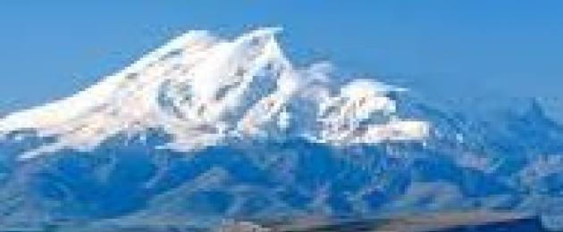
Elbrus is the highest point of the Caucasus, which is the highest peak not only in Russia, but also in Europe. The location of the mountain is such that a variety of nationalities live around it, giving it their unique names: Oshkhomakho, Alberis, Yalbuz and Mingitau.
The most important mountain in the Caucasus ranks fifth on Earth among mountains formed in this way (as a result of a volcanic eruption).
The height of the most gigantic peak in Russia is five kilometers six hundred and forty-two meters.
More details about the highest peak of the Caucasus
The highest height of the Caucasus Range is Russia. It looks like two cones, between which (a distance of 3 km from each other) at an altitude of 5200 meters there is a saddle. The highest of them has, as already noted, a height of 5642 meters, a smaller one - 5621m.

Like all peaks of volcanic origin, Elbrus consists of 2 parts: a 700-meter pedestal of rocks and a bulk cone (1942 meters) - the result of a volcanic eruption.
The peak is covered with snow starting from a height of about 3500 meters. In addition, there are glaciers, the most famous of which are the Small and Big Azau and Terskop.
The temperature at the highest point of Elbrus is -14 °C. Precipitation here almost always falls in the form of snow and therefore the glaciers do not melt. Due to the good visibility of the Elbrus peaks from different remote places and at different times of the year, this mountain also has an interesting name - Small Antarctica.
It should be noted that for the first time the eastern peak was conquered by climbers in 1829, and the western one - in 1874.
Glaciers located on the top of Elbrus feed the Kuban, Malka and Baksan rivers.
Central Caucasus: ridges, parameters
Geographically, the Central Caucasus is part of the Greater Caucasus, located between the mountains of Elbrus and Kazbek (in the west and in the east). In this section, the length of the Main Caucasian Range is 190 kilometers, and if we take into account the meanders, about 260 km.

The border of the Russian state passes through the territory of the Central Caucasus. Behind it are South Ossetia and Georgia.
22 kilometers west of Kazbek (eastern part of the Central Caucasus), the Russian border shifts slightly to the north and runs to Kazbek, skirting the Georgian Terek valley (upper part).

On the territory of the Central Caucasus, 5 parallel ridges are distinguished (oriented along the latitudes):
- The main Caucasian ridge (height up to 5203 m, Mount Shkhara).
- Ridge Lateral (height up to 5642 meters, Mount Elbrus).
- Ridge Rocky (height up to 3646 meters, Mount Karakaya).
- Ridge Pastbishchny (up to 1541 meters).
- Ridge Wooded (height 900 meters).
Tourists and climbers mainly visit and storm the first three ridges.
North and South Caucasus
The Greater Caucasus, as a geographical object, originates from the Taman Peninsula, and ends in the region. All subjects of the Russian Federation and countries located in this region belong to the Caucasus. However, in terms of the location of the territories of the constituent entities of Russia, there is a certain division into two parts:
- The North Caucasus includes the Krasnodar Territory and Stavropol Territory, North Ossetia, the Rostov Region, Chechnya, the Republic of Adygea, Ingushetia, Kabardino-Balkaria, Dagestan and Karachay-Cherkessia.
- South Caucasus (or Transcaucasia) - Armenia, Georgia, Azerbaijan.

Elbrus region
The Elbrus region is geographically the westernmost section of the Central Caucasus. Its territory covers the upper reaches of the Baksan River with its tributaries, the area north of Elbrus and the western spurs of Mount Elbrus to the right bank of the Kuban. The largest peak of this region is the famous Elbrus, located to the north and located in the Side Range. The second highest peak is (4700 meters).

The Elbrus area is famous for a large number of peaks with steep ridges and rocky walls.
The largest glaciers are concentrated in the huge Elbrus glacier complex, which has 23 glaciers (total area - 122.6 sq. km).
Location of states in the Caucasus
- The Russian Federation partially occupies the territory of the Greater Caucasus and its foothills from the Dividing and Main Caucasian Ranges to the north. 10% of the total population of the country lives in the North Caucasus.
- Abkhazia also has territories that are parts of the Greater Caucasus: the area from the Kodori to the Gagra ranges, the Black Sea coast between the river. Psou and Enguri, and to the north of Enguri a small part of the Colchis lowland.
- South Ossetia is located in the central region of the Greater Caucasus. The beginning of the territory is the Main Caucasian Range. The territory extends in a southerly direction from it, between the Rachinsky, Suramsky and Lomissky ranges, to the very valley of the Kura River.
- Georgia has the most fertile and populated parts of the country in the valleys and lowlands between the Lesser and Greater Caucasus ranges to the west of the Kakheti range. The most mountainous parts of the country are Svaneti, a section of the Greater Caucasus between the Kodori and Suram ranges. The Georgian territory of the Lesser Caucasus is represented by the Meskheti, Samsar and Trialeti ranges. It turns out that the whole of Georgia is within the Caucasus.
- Azerbaijan is located between the Dividing Range in the north and the Araks and Kura rivers in the south, and between the Lesser Caucasus and the Kakheti Range and the Caspian Sea. And almost all of Azerbaijan (the Mugan Plain and the Talysh Mountains belong to the Iranian Highlands) is located in the Caucasus.
- Armenia has part of the territory of the Lesser Caucasus (slightly east of the Akhuryan River, which is a tributary of the Araks).
- Turkey occupies the southwestern section of the Lesser Caucasus, representing 4 eastern provinces of this country: Ardahan, Kars, partly Erzurum and Artvin.
The mountains of the Caucasus are both beautiful and dangerous. According to the assumptions of some scientists, there is a possibility that in the next hundred years the volcano (Mount Elbrus) may wake up. And this is fraught with catastrophic consequences for neighboring regions (Karachay-Cherkessia and Kabardino-Balkaria).
But, whatever it may be, the conclusion follows that there is nothing more beautiful than the mountains. It is impossible to describe all the magnificent nature of this fabulous mountain country. To feel all this, you should visit these amazingly beautiful paradise places. They are especially impressively viewed from the heights of the peaks of the Caucasus Mountains.
Greater Caucasus- a mountain system between the Black and Caspian Seas. It extends over 1100 km from the northwest to the southeast, from the Anapa region and the Taman Peninsula to the Absheron Peninsula on the Caspian coast, near Baku. The highest peak is Elbrus (5642 m).
The state border of the Russian Federation with Abkhazia, Georgia, South Ossetia and Azerbaijan passes through the Greater Caucasus.
Scheme of the ridges of the Greater Caucasus. Volcanoes are marked with red circles.
The Greater Caucasus, together with the Lesser Caucasus, makes up the Caucasus Mountains and is separated from the latter by the Colchis and Kura-Araks lowlands and the Kura valley in the middle reaches between them.
The Greater Caucasus reaches its maximum width in the Elbrus region (up to 180 km). In the axial part there is the Main Caucasian (or Dividing) Range, to the north of which a number of parallel ranges (mountain ranges) extend - the Side Range, the Rocky Range, etc.
Parts and districts

View from Ushba to Elbrus. Photo by O. Fomichev.
Traditionally, the Greater Caucasus is divided into 3 parts:
Table 1. The peaks of the Caucasus are higher than 4700 m (bold type indicates the height according to the topographic map at a scale of 1:50000).
| N | Peak name | Height | Part of BC | Area |
|---|---|---|---|---|
| 1 | Elbrus | 5642 | Central | Elbrus region |
| 2 | Dykhtau | 5205 | Central | Bezengi |
| 3 | Shkhara | 5203 | Central | Bezengi |
| 4 | Koshtantau | 5152 | Central | Bezengi |
| 5 | Dzhangitau | 5085 | Central | Bezengi |
| 6 | Kazbek | 5034 | Central | Prikazbeche |
| 7 | Mizhirgi | 5019 | Central | Bezengi |
| 8 | Katyntau | 4979 | Central | Bezengi |
| 9 | Gestola | 4860 | Central | Bezengi |
| 10 | Tetnuld | 4858 | Central | Bezengi |
| 11 | Jimaraikhoh | 4780 | Central | Tepli-Dzhimaraisky |
| 12 | Ushba | 4700 | Central | Elbrus region |
Climate

Rest in the Adish Icefall. Photo by A. Lebedev (1989)
The climatic features of the Greater Caucasus are determined by the altitudinal zonality and the rotation of the mountain barrier formed by it at a certain angle to the western moisture-bearing air flows - the Atlantic cyclones and the Mediterranean western air currents of the middle layers of the troposphere. This rotation has a decisive influence on the distribution of precipitation.
The wettest is the western part of the southern slope, where more than 2500 mm of precipitation falls annually in the highlands. The record amount of precipitation falls on the Achishkho ridge near Krasnaya Polyana - 3200 mm per year, this is the wettest place in Russia. Winter snow cover in the area of the meteorological station Achishkho reaches 5-7 meters!
| N | Name of the glacier | Length km | Area sq. km | end height | Firn line height | Area |
|---|---|---|---|---|---|---|
| 1 | Bezengi | 17.6 | 36.2 | 2080 | 3600 | Bezengi |
| 2 | Karaug | 13.3 | 34.0 | 2070 | 3300 | Karaug |
| 3 | Dykh-Su | 13.3 | 26.6 | 1830 | 3440 | Bezengi |
| 4 | Lekzyr | 11.8 | 33.7 | 2020 | 3090 | Elbrus region |
| 5 | Big Azau | 10.2 | 19.6 | 2480 | 3800 | Elbrus region |
| 6 | zanner | 10.1 | 28.8 | 2390 | 3190 | Bezengi |
Glaciation is especially significant in the Central Caucasus and in the eastern part of the Western Caucasus. In the Eastern Caucasus, small glaciers are found only in individual high mountain nodes.
Here is a detailed map of the Caucasus Mountains with the names of cities and towns in Russian. Move the map by holding it with the left mouse button. You can move around the map by clicking on one of the four arrows in the upper left corner.
You can change the scale using the scale on the right side of the map or by turning the mouse wheel.
What country is the Caucasus Mountains in?
Caucasian Mountain is located in Russia. This is a wonderful, beautiful place, with its own history and traditions. Coordinates of the Caucasus Mountains: northern latitude and eastern longitude (show on a large map).
virtual walk
The figurine of a "little man" above the scale will help you take a virtual tour of the cities of the Caucasus Mountains. By pressing and holding the left mouse button, drag it to any place on the map and you will go for a walk, while inscriptions with the approximate address of the area will appear in the upper left corner. Choose the direction of movement by clicking on the arrows in the center of the screen. The "Satellite" option at the top left allows you to see the relief image of the surface. In the "Map" mode, you will get the opportunity to get acquainted in detail with the roads of the Caucasus Mountains and the main attractions.
antiqus classicus
Caspian mountains
- Caspian mountains
- and gate (Greek Κασπία ὄρη, lat. Caspii monies).
- 1. Panic mountains between Armenia and Albania on the one hand and Media on the other (now Qaradagh, Siah-Koh, i.e. Black and Talysh mountains). In a broad sense, this name means the entire chain of mountains south of the river. Arak (from the Kotur River to the Caspian Sea). Here were the so-called.
Caspian Gate (Caspiapila), a narrow mountain pass 8 Roman miles long and one chariot wide (now the Chamar pass between Narsa-Koh and Siah-Koh). This was the only way from Northwest Asia to the northeastern part of the Persian state, because the Persians blocked this passage with iron gates, which were guarded by guards (claustra Caspiarum).
The Caucasus Mountains are a mountain system between the Black and Caspian Seas.
It is divided into two mountain systems: the Greater Caucasus and the Lesser Caucasus.
The Caucasus is often divided into the North Caucasus and Transcaucasia, the border between which is drawn along the Main, or Watershed, ridge of the Greater Caucasus, which occupies a central position in the mountain system.
The most famous peaks are Mt. Elbrus (5642 m) and Mt.
Kazbek (5033 m) is covered with eternal snow and glaciers.
From the northern foot of the Greater Caucasus to the Kuma-Manych depression, Ciscaucasia extends with vast plains and uplands. To the south of the Greater Caucasus are the Colchis and Kura-Araks lowlands, the Inner Kartli plain and the Alazan-Avtoran valley [the Kura depression, within which the Alazan-Avtoran valley and the Kura-Araks lowland are located]. In the southeastern part of the Caucasus - the Talysh mountains (up to 2492 m high) with the adjacent Lankaran lowland. In the middle and in the west of the southern part of the Caucasus is the Transcaucasian Highlands, which consists of the ranges of the Lesser Caucasus and the Armenian Highlands (Aragats, 4090 m).
The Lesser Caucasus is connected to the Greater Caucasus by the Likhi Ridge, in the west it is separated from it by the Colchis Lowland, in the east by the Kura Depression. The length is about 600 km, the height is up to 3724 m.
Mountains near Sochi - Aishkho (2391 m), Aibga (2509 m), Chigush (3238 m), Pseashkho and others.
Location of the mountain system of the Caucasus Mountains on the world map
(mountain system boundaries are approximate)
Hotels in Adler from 600 rubles per day!
Caucasian mountains or Caucasus- a mountain system between the Black and Caspian Seas with an area of \u200b\u200b~ 477488 m².
The Caucasus is divided into two mountain systems: the Greater Caucasus and the Lesser Caucasus, very often the mountain system is divided into Ciscaucasia (Northern Caucasus), Greater Caucasus and Transcaucasia (South Caucasus). Along the crest of the Main Range, the state border of the Russian Federation with the countries of Transcaucasia passes.
highest peaks
The largest mountain peaks of the Caucasus Mountains (indicators of various sources may vary).
|
Height, in m |
Notes |
|
| Elbrus | 5642 m | the highest point of the Caucasus, Russia and Europe |
| Shkhara | 5201 m | Bezengi, the highest point in Georgia |
| Koshtantau | 5152 m | Bezengi |
| Pushkin Peak | 5100 m | Bezengi |
| Dzhangitau | 5085 m | Bezengi |
| Shkhara | 5201 m | Bezengi, the highest point of Georgia |
| Kazbek | 5034 m | Georgia, Russia (highest point in North Ossetia) |
| Mizhirgi Western | 5025 m | Bezengi |
| Tetnuld | 4974 m | Svaneti |
| Katyn-tau or Adish | 4970 m | Bezengi |
| Shota Rustaveli Peak | 4960 m | Bezengi |
| Gestola | 4860 m | Bezengi |
| Jimara | 4780 m | Georgia, North Ossetia (Russia) |
| Ushba | 4690 m | |
| Tebulosmta | 4493 m | the highest point of Chechnya |
| Bazarduzu | 4485 m | the highest point of Dagestan and Azerbaijan |
| shang | 4451 m | the highest point of Ingushetia |
| Adai-hoh | 4408 m | Ossetia |
| Diklosmta | 4285 m | Chechnya |
| Shahdag | 4243 m | Azerbaijan |
| Tufandag | 4191 m | Azerbaijan |
| Shalbuzdag | 4142 m | Dagestan |
| Aragats | 4094 m | the highest point in Armenia |
| Dombay-Ulgen | 4046 m | Dombai |
| Zilga-Khokh | 3853 m | Georgia, South Ossetia |
| TASS | 3525 m | Russia, Chechen Republic |
| Tsitelikhati | 3026.1 m | South Ossetia |
Climate
The climate of the Caucasus is warm and mild, with the exception of the highlands: at an altitude of 3800 m, the border of "eternal ice" passes. In the mountains and foothills there is a large amount of precipitation.
Flora and fauna
The vegetation of the Caucasus is rich in species composition and diversity: oriental beech, Caucasian hornbeam, Caucasian linden, noble chestnut, boxwood, cherry laurel, Pontic rhododendron, some species of oak and maple, wild persimmon, as well as subtropical tea bush and citrus.
In the Caucasus, there are brown Caucasian bears, lynxes, forest cats, foxes, badgers, martens, deer, roe deer, wild boars, bison, chamois, mountain goats (tours), small rodents (forest dormouse, field voles). Birds: magpies, thrushes, cuckoos, jays, wagtails, woodpeckers, owls, owls, starlings, crows, goldfinches, kingfishers, tits, Caucasian black grouse and mountain turkeys, golden eagles and lambs.
Population
More than 50 peoples live in the Caucasus (for example: Avars, Circassians, Chechens, Georgians, Lezgins, Karachais, etc.) which are designated as Caucasian peoples. They speak Caucasian, Indo-European, as well as Altaic languages. Largest cities: Sochi, Tbilisi, Yerevan, Vladikavkaz, Grozny, etc.
Tourism and rest
The Caucasus is visited for recreational purposes: there are many sea resorts on the shores of the Black Sea, the North Caucasus is popular for its balneological resorts.
Rivers of the Caucasus
The rivers originating in the Caucasus belong to the basins of the Black, Caspian and Azov Seas.
- swell
- Kodori
- Ingur (Enguri)
- Rioni
- Kuban
- Podkumok
- Araks
- Liakhva (Big Liakhvi)
- Samur
- Sulak
- Avar Koysu
- andean koisu
- Terek
- Sunzha
- Argun
- Malka (Kura)
- Baksan
- Chegem
- Cherek
Countries and Regions
The following countries and regions are located in the Caucasus.
- Azerbaijan
- Armenia
- Georgia
- Russia: Adygea, Dagestan, Ingushetia, Kabardino-Balkaria, Karachay-Cherkessia, Krasnodar Territory, North Ossetia-Alania, Stavropol Territory, Chechnya
In addition to these countries and regions, there are partially recognized republics in the Caucasus: Abkhazia, South Ossetia, Nagorno-Karabakh.
The largest cities of the Caucasus
- Vladikavkaz
- Gelendzhik
- Hot key
- Grozny
- Derbent
- Yerevan
- Essentuki
- Zheleznovodsk
- Zugdidi
- Kislovodsk
- Kutaisi
- Krasnodar
- Maykop
- Makhachkala
- Mineral water
- Nazran
- Nalchik
- Novorossiysk
- Pyatigorsk
- Stavropol
- Stepanakert
- Sukhum
- Tbilisi
- Tuapse
- Tskhinvali
- Cherkessk
Cheap flights to Sochi from 3000 rubles.
Where is it located and how to get there
Address: Azerbaijan, Armenia, Georgia, Russia
- In contact with 0
- Google+ 0
- OK 0
- Facebook 0