Landslide(until 1945 Kikineiz; Ukrainian. Opolzneve, Crimean. Kikineiz, Kikineiz) - a village on the southern coast of Crimea, part of the Simeiz settlement council of Greater Yalta.
In Opolznevoy there is a branch of the state farm-factory "Livadia", and on the eastern outskirts there is a children's boarding house (the former pioneer camp "Young Builder", where at one time they spent their holidays, rested and studied the children of the workers of the trust "Tyumen-gazstroy").
The name of the village is associated with a grandiose landslide collapse that occurred in this area in 1786. One of the “outcastes” of the Main Biyuk-Isar Ridge (734 m), composed of light gray marble-like limestone. At the top of the mountain was one of the Taurus shelters. In the era of the early Middle Ages, this place was occupied by a fortification of impressive size (Byzantine fortress). Hence the name that this picturesque landscape monument received.
Past Biyuk-Isar there are several trails to the yaila through the Miyesis-Bogaz-Sokhakh and Kopek-Bogaz-Sokhakh passes, the wide and accessible passes of Pelakia and Eski-Bogaz. Obviously, the diversity of paths led to the fact that where they began, as early as the end of the 18th century. the village of Kikeneiz arose.
It became widely known due to the fact that it had a station of malposts - mail coaches for transporting passengers. And before the construction of the southern coast highway, until 1848, from here the path began from the southern coast to the northern foothills along the Shaitan-Merdven (Devil's Stairs) "> Devil's Stairs - Pass, which is located at 9 km west of the village.
These places are mentioned by I. M. Muravyov-Apostol, A. S. Pushkin, A. S. Griboedov, Adam Mickiewicz.
During the Great Patriotic War, partisans repeatedly came to the village. In the autumn of 1942, they carried out a bold operation to evacuate sick, wounded, and weakened comrades to the mainland. On the night of October 6-7, 85 partisans descended from the mountainous Crimea through Miyesis-Bogaz (the passage from the yayla above Opolznev) to the sea at Cape Kikeneiz. Despite enemy shelling, they managed to safely board two boats and depart for Tuapse.
In Opolznevo, an obelisk was erected on the grave of 44 Soviet soldiers who died during the liberation of Crimea from the Nazis in the spring of 1944.
Landslide today
A landslide-village, unfortunately, is not developing. Before the war, the vast majority of Tatars lived here, after the war, Russians settled in the empty houses. At the height of the perestroika campaign for the return of the Tatars to the Crimea, on the outskirts of Opolznevoy, on stones and rocks, the Tatars were allocated a fairly large area for settlement. This was written a lot in the Crimean newspapers, how hard-working Tatars bite into the rocks, managing not only to build the foundations of houses there, but also to equip gardens. Thus, the village is now half Russian and half Tatar.
Before the construction of the new Yalta-Sevastopol highway, a very busy traffic flow of the Yalta-Sevastopol route along the old Sevastopol highway went through Opolznevoye. As soon as the new highway was put into operation, the section of the old highway up to the Forosskaya Church became unnecessary, and began to slowly degrade. Before the start of perestroika, the old highway was patched up, but then abandoned for a long time. Spontaneous dumps formed around it, in some places the highway began to creep heavily. Somewhere in 2007, one of the most beautiful roads in Crimea was repaired and now you can drive from Alupka to the Foros Church and enjoy the amazing mountain landscape.
In order to go to the outside world, the residents of Opolznevoye need to use two slopes that lead to the highway - one over Katsiveli, the other - over Kastropol. On foot and gardens, you can go down to the highway in the Ponizovka area - this is the shortest path to the sea.
Under socialism, urban state transport went to Opolzneve. Small PAZ-iki along the Simeiz-Kastropol route, four or five pieces a day. During perestroika, these buses were canceled, and now the inhabitants of Opolznevoye are forced to go down to the highway for quite a long time to use the Yalta-Foros buses.
Historical facts
The Pilyaki volcanic mountain rises above Opolznevo as a dark treeless peak, the rest of it is covered with forest, with the exception of a small valley located at an altitude of about 500 m and at an altitude of 800 m - Abitovaya meadow.
In 1786, a passionate mineralogist, later an outstanding figure in the French bourgeois revolution, the creator of the republican calendar, Gilbert Romm, traveled in these parts, the same one who in 1795 led the uprising of Parisian workers against the Thermidorian reaction.
It was at the Pilyaki-Hyr volcanic placers that Romm found “a blackish, in some places gray rounded pumice,” as he wrote in his diary, and added it to his rich collection, which he then took to France. Subsequently, his collection was transferred to the museum in Montpellier.
Kikeneiz was visited by many famous travelers. A. S. Pushkin mentions him in a letter to A. A. Delvig: “I traveled around the midday coast, and the journey of Muravyov-Apostol revived many memories in me; but his terrible passage over the rocks of Kikeneis did not leave the slightest trace in my memory. The poet's Crimean memories were revived by the book of I. M. Muravyov-Apostol "Journey through Tauris in 1820" (St. Petersburg, 1823), which he read already in Mikhailovsky, a few years after a short stay in the Crimea.
In 1825, the famous Polish poet Adam Mickiewicz visited Kikeneiz. In the sonnet "Mount Kikeneiz". Here A. Mickiewicz began to write, but did not finish the sonnet "Hawk" ("At the top of Kikeneiz"). Impressed by the amazing magnificence of the nature of midday Taurida, A. Mickiewicz created the widely known cycle "Crimean Sonnets", which he dedicated to "companions in the Crimea"; among them was the Polish writer, author of historical novels Henryk Rzewuski.
A.S. Griboedov, the author of the immortal comedy “Woe from Wit”, also mentions Kikeneiz in his travel notes of June 30, 1825: mountains Kukuneys; between it and Kuchuk-koy there is a collapse ... from there a view of the extreme cape of the southern coast of Forus ... ".
Opolznevoye is notable for the fact that at the beginning of the century the famous revolutionary P. L. Voikov visited here more than once. This is where his father lived. From here, in July 1906, young Voikov fled, fearing arrest after a failed attempt on the life of an ardent reactionary, the mayor of Yalta Dumbadze, in which he participated.
How to get there?
You can go to Opolznevoye along a three-kilometer branch of the highway (it is two kilometers east of the Smena sports camp). And best of all, from the Scientific Base of the Astrosoviet of the USSR Academy of Sciences, which is on Mount Koshka, make a trip along the old south coast highway. This way you will see from all sides the Pilyaki-Camel-Khir ridge - a very remarkable mountain formation, a monument of the Middle Jurassic volcanism in the Crimea, the same as the famous Karadag.
Detailed map of Opolznevoe in Russian. Satellite map of Opolzneve in Crimea. Where is Opolznevoe on the map:
Examine the schematic map or switch to the satellite map in the lower left corner. schematic map– city plan with street names and house numbers in Russian. The schematic map shows sights and tourist sites, the location of railway stations, shops, restaurants and shopping centers, a map of the city's roads. satellite map will allow you to view satellite photos of the city thanks to images from the Google Maps service.
You can zoom in on the online map, scaling it to street and house numbers. To change the scale, use the "+" (zoom in) and "-" (zoom out) icons located in the lower right corner of the map. You can also zoom in or out on the map using the mouse wheel. Left mouse button zooms in on the map, right mouse button zooms out. The mouse can move the interactive map in all directions by grabbing the left mouse button to any place on the map.
interactive map is a very convenient and modern guide for exploring the city, its districts and attractions, hotels, places of recreation and entertainment. An online map on the site can become an indispensable tool for you in independent travel. Interactive map provided by Google Maps.
Despite the “threatening” name, the village of Opolznevoye in the Crimea has been popular with travelers since the century before last. True, it was considered not as the final destination of the movement, but as a convenient place to stop on the way to Yalta.
Where is the village of Opolznevoe on the map. Story
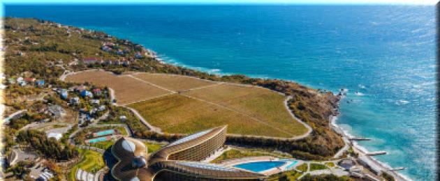
It is located southwest of Yalta - 25 km. It is 60 km from here, up to 110 km. The nearest villages are Blue Bay, Simeiz, Ponizovka, Parkovoye and.
Byzantine fortress
According to archaeologists, more Tauris settled in the place where Opolznevoye now stands. But the existence of the village itself can be counted from Byzantine times, when a large fortress appeared on the Biyuk-Isar rock. During her time, a settlement arose, which gave rise to the modern one.
At first it was inhabited by Christians. But after the Turkish conquest, it gradually became Muslim. After the village was registered as completely or predominantly Tatar. It did not have a Christian church, but only a mosque. The name is also similar to the traditions of the Tatars - Kikineiz (or Kekeneiz). They changed it after the Great Patriotic War, after the deportation of this people.
Opolznevoye owes its name to a natural disaster that occurred not far from it in 1786. Then, indeed, a large landslide occurred in the mountains. It was noticed because a route passed through the village for travelers wishing to use the Devil's Stairs. The village of Opolznevoye retained its significance as a transshipment settlement even after the road was laid through the Baidar Gates in 1848. There was a post station where travelers rested and changed horses. At various times, this "post office" was used by A.S. Pushkin, A.S. Griboyedov, Adam Mitskevich and Decembrist I.M. Muravyov-Apostle. Gilbert Romm, a French revolutionary, the creator of the republican calendar and a good geologist, also visited the Opolznevoy area. The samples collected in the Crimea ended up in his geological collection, which he then transferred to a museum in the city of Montpellier.
Today, Opolznevoye is a small village that is part of the Big Yalta conglomerate. in the full sense, it is not, as it is quite far from the sea. It has about half a thousand permanent residents. its typical for mountainous Taurida - rather hot summers and moderately cold with frequent winds and snowfalls.
Accommodation and food in the village of Opolznevoy
The situation with the tourist infrastructure in Opolznevoye is not typical for the South Coast - the village is located at a distance from the sea. Housing here is inexpensive, but there are few offers. The private sector is not focused on tourists, as the Republic of Crimea offers in coastal towns. But you can try to "finish" the room. The conditions will be modest (without fancy European-style repairs), but the prices will match them.
There is in with. Landslide and hotels. The most famous of them is the fashionable resort complex Mriya. This institution is for wealthy clients, with all conceivable amenities and advantages. In it, you need to be prepared for the fact that a day of rest will cost 10 thousand or more. Formally, "Mriya" is located outside the borders of Opolznevoy, but next to it, in.
There are much more modest hotels here. So, the general sanatorium "Dawns of Russia" receives guests, the boarding house "Vesely" is also located here. There is a children's resort camp "Young Builder". Its ancestor was the departmental pioneer camp of the Tyumen oil workers (under the Soviets). 
In the village of Opolznevoye, you will have to overcome considerable distances on foot, and over rough terrain. Public transport does not come here, you have to go to the highway.  A couple of years ago, the village authorities equipped a site on the sea for visitors and villagers, but you will have to walk more than 2 km to it in one direction (along the slope). The trail is cultivated, equipped with stairs, but all the same, forces must be calculated realistically.
As for the question of what to see here - yes, almost nothing. In the village there is a monument to those who died during the war - that's all. For better go to (by own car or go out on the highway). Around the Opolznevoye there is an opportunity to climb the mountains for your own pleasure. It is not difficult to climb the Pilyaki volcanic peak, as well as visit an interesting treeless valley near its wooded spur - Abitova Polyana.
The southern slopes rise above the village - a good direction for lovers of mountain walks. Connoisseurs of geology will also be interested in the Biyuk-Isar massif. You can walk up to
Landslide(until 1945 Kikineiz; Ukrainian Landslide, Crimean Tat. Kikineiz, Kikineiz) is a village on the southern coast of Crimea. Included in the urban district of Yalta of the Republic of Crimea (according to the administrative-territorial division of Ukraine - the Yalta City Council of the Autonomous Republic of Crimea, as part of the Simeiz village council).
Geography
The village is located on the Old Sevastopol highway (highway T-2703), approximately at an equal distance from the sea and the southern cliffs of the Ai-Petri Yaila of the Main Range of the Crimean Mountains, the height of the village center above sea level is 334 m. The distance to Simeiz is about 7 km, to Yalta - 27 km.
Story
Located on the approach to the main, in the past, passes of the Crimean mountains (Miyesis-Bogaz-Sokhakh, Kopek-Bogaz-Sokhakh, Pelakia and Eski-Bogaz, and, also, not far from Shaitan-Merdven), the village has existed since ancient times. In the cemetery near the village, dolmen burials dating back to the 6th-5th centuries BC were found. e., and also, in the area of the village, amphorae shards and fragments of tiles of Greek production of a later time. In the 10th century, on the Biyuk-Isar rock, above the village, a fortification arose, known in science under the same name, which later became a feudal castle. There is an opinion that the castle, like the village, was part of the Mangup principality. Perhaps it was a border territory that changed subordination, since Chinicheo also mentioned in the treasury lists of Cafa (cartolfri della Masseria) kept in Genoa, dating back to about 1360.
After the defeat of Kafa by the Ottomans in 1475, the village was subordinated to Inkirman in the Mangup kadylyk of the Kefin sanjak (later the eyalet) of the empire. According to the materials of the census of the Kefinsky sanjak in 1520 in the village keknos there was 1 Muslim family and 39 non-Muslim (that is, Christian) families, of which 2 were “widowed” (who lost their male breadwinner). In 1542, there were no longer Muslims, and there were 37 Christians (of which 3 were incomplete) and four more adult single men. In the 17th century, Islam began to spread on the southern coast of Crimea, and, apparently, all the inhabitants soon accepted Islam, since already in Jizye defter Liwa-i Kefe- The Ottoman tax rolls of 1652, where Christian taxpayers were listed, the village does not appear. Kekeneiz is also absent from the lists of the “Vedomosti about the Christians Brought Out of the Crimea to the Sea of Azov” by A. V. Suvorov and Metropolitan Ignatius.
Kekeneiz belonged to the Crimean Khanate for only 9 years - from the acquisition of independence by the Khanate in 1774 to the annexation of Crimea to Russia (8) on April 19, 1783. Judging by Cameral Description of Crimea... 1784, in the last period of the Crimean Khanate Kikeneiz was in Mangupsky Adam's apple bakchi-saray kaymakanism.
After the annexation of Crimea to Russia (8) on April 19, 1783, (8) on February 19, 1784, by the nominal decree of Catherine II to the Senate, the Tauride region was formed on the territory of the former Crimean Khanate and the village was assigned to the Simferopol district. After the Pavlovsk reforms, from 1796 to 1802, it was part of the Akmechetsky district of the Novorossiysk province. According to the new administrative division, after the creation of the Taurida province on October 8 (20), 1802, Kekeneiz was included in the Mahuldur volost of the Simferopol district.
By Sheets of all the villages in the Simferopol district, consisting of an indication in which volost, how many yards and souls ... dated October 9, 1805, in the village of Kekeneiz there were 47 households and 272 residents, exclusively Crimean Tatars. On the military topographic map of Major General Mukhin in 1817, the village Kikineis signposted with 32 yards. After the volost division reform of 1829, Kikeneiz, according to "Vedomosti about state-owned volosts of the Tauride province of 1829", transferred to the Alushta volost.
By personal decree of Nicholas I of March 23 (old style), 1838, on April 15, a new Yalta district was formed and the village was transferred to the Derekoy volost. On the map of 1842, Kikeneiz is marked with 47 courtyards.
As a result of the zemstvo reform of Alexander II in the 1860s, the village was assigned to the Derekoy volost. According to "List of populated places of the Tauride province according to the data of 1864", compiled according to the results of the VIII revision of 1864, Kekeneiz is a state Tatar village with 47 households, 328 inhabitants, a mosque and a postal station at the rivers Biyuk-Tash and Biyuk-Uzeni. On the three verst The map of 1865-1876 shows 30 households in the village. For 1886 in the village at the river Biyuk-Tosh, according to the directory "Volosti and the most important villages of European Russia", 254 people lived in 38 households, a mosque and a shop operated. According to "Memorial book of the Tauride province of 1889", according to the results of the X revision of 1887, in the village of Kekeneiz there were 94 households and 423 inhabitants. On the milestone On the map of 1890, 88 households with a Tatar population are indicated in the village.
After the zemstvo reform of the 1890s, which took place in the Yalta district after 1892, the village remained part of the transformed Derekoy volost. By "... Memorable book of the Tauride province for 1892" in the village of Kekeneiz, which was part of the Kekeneiz rural society, there were 258 residents in 53 households. By "... Memorable book of the Tauride province for 1902" in the villages of Kekeneiz, Kuchuk-Koy and Limeny, which constituted the Kekeneiz rural society, there were 830 inhabitants in 88 households. V Statistical reference book of the Taurida province. Part II-I. Statistical essay, issue eight Yalta district, 1915, in the Derekoy volost of the Yalta district, the village of Kekeneiz is also listed.
After the establishment of Soviet power in the Crimea, according to the decision of the Krymrevkom of January 8, 1921, the volost system was abolished and the village was subordinated to the Yalta district of the Yalta district. In 1922, the uyezds were given the name okrugs. According to List of settlements of the Crimean ASSR according to the All-Union census on December 17, 1926, in the village of Kekeneiz, the center of the Kekeneiz village council of the Yalta region, there were 167 households, of which 149 were peasants, the population was 661 people, of which 612 were Crimean Tatars, 29 Russians, 13 Greeks, 3 Ukrainians, 2 Jews, 2 were recorded in the “other” column , the Tatar school of the first stage operated.
In 1944, after the liberation of the Crimea from the Nazis, according to the Decree of the State Defense Committee No. 5859 of May 11, 1944, on May 18, the Crimean Tatars were deported to Central Asia. On August 12, 1944, Decree No. GOKO-6372s “On the resettlement of collective farmers in the regions of Crimea” was adopted, according to which 3,000 families of collective farmers were resettled from the Rostov region of the RSFSR to the region. By the Decree of the Presidium of the Supreme Soviet of the RSFSR of August 21, 1945, Kekeneiz was renamed into Opolznevoe and the Kekeneiz village council - into Opolznevsky. The time of the abolition of the village council has not yet been established, perhaps it happened during the enlargement campaign of 1962 (a consequence of the decree of the Presidium of the Supreme Soviet of the Ukrainian SSR “On the consolidation of rural areas of the Crimean region”, December 30, 1962). After the construction of a new highway in the 1960s H-19 Sevastopol - Yalta the village turned out to be far from the main transport routes and is gradually falling into decay.
Kekeneiz in literature
From time immemorial, the village was an important point on the road from the southern coast, and, after the annexation of Crimea to Russia and the construction of Sevastopol, it was a kind of “junction station”. Here they changed horses before climbing Damn stairs, and, after the construction of the highway in 1848, a malpost station was located through the Baydar gates. Many famous travelers passing from the south coast left reviews of the village: Muravyov-Apostol in the book “Journey through Taurida in 1820”, Alexander Sergeevich Pushkin in a letter to Delvig, Alexander Griboyedov in travel notes dated June 30, 1825, in 1825 in Kikeneize was visited by Adam Mickiewicz.
- In contact with 0
- Google+ 0
- OK 0
- Facebook 0