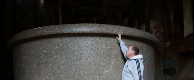
Today we have a huge number of artifacts that cannot be repeated today due to the lack of technology, equipment and specialists, and which testify that a global civilization existed on Earth for 200 years and earlier, compared to which we are children in the sandbox. A few examples: Babolovskaya bath. Granite. Weight 48 tons.

Here is what a turner who visited her writes:


Further, all the cities on the planet were built of stone in the antique style with pre-designed layouts of streets, avenues, embankments, etc. All cities had a stone bastion wall, the construction volume of which is often equal to the construction volume of the city itself. More on this in my article: The geography of the global world before nuclear war on the example of ancient architecture and bastion stars http://wakeuphuman.livejournal.com/921.html In the region of 1780-1815, a thermonuclear war took place, most likely not for the first time on the planet, which resulted in the nuclear winter of 1816 - a year without a summer. The Anglo-Saxons call it Eighteen Hundred and Froze to Death. I will also give a few screenshots from Google Earth of photos of nuclear craters on the territory, for example, Belarus. It is easy to find hundreds of such funnels in almost all countries. The white traces around the sinkholes are broken limestone, the main building material of that time.


In the funnels of Belarus given as an example, there is water, since the level of groundwater is apparently high. But there are a lot of funnels without water on the surface of the planet. For example, in Ukraine:


As a result of the nuclear winter, almost all plants froze to death and polar caps formed. This confirms the almost complete absence of trees older than 200 years in the northern hemisphere. Some of them burned out in the war, some froze. To visually evaluate this, type Roger Fenton Crimea or James Robertson Crimea in Google and click show pictures. You will see photographs of these two first war photographers sent to the Crimea in 1853 (already after the nuclear war, approximately 40 years later) to photograph the siege of Sevastopol. Compare vegetation then and now. An example of one photo of Fenton near Sevastopol:

Also type in Google "Siberia photo of the 19th century". You will see many photographs from the end of the 19th century, in which trees have just begun to grow. For example, Sverdlovsk region:

After this war, we rolled back in development, to the level of a feudal society. The Anglo-Saxons had a profit, since they got the least, they crushed the remnants of the world for 150 years for themselves, reinvented the steam engine on coal and off they go - now the era of oil and gas, nuclear energy and our industrial complex uses the entire periodic table, which he supposedly invented in a dream. In fact, they just threw it through it. Let's move on to the most interesting. I affirm that the current civilization is only a shadow of the bygone one. We are children compared to them. It is impossible to prove this through the industrial equipment of a past civilization, because it was simply disposed of, melted down. For example, after the collapse of the USSR, drunks dug trenches and cables and water pipes were taken out of the ground to be handed over to the metal collection point. But how to prove it? And it's easy. If the bygone civilization was much more developed than ours, then the entire periodic table was also needed for the functioning of its industrial-industrial and metallurgical complex. And all isotopes of elements. And there are almost all the elements of the periodic system in the rock and earth. So, I need to show you large-scale traces of the removal of rock from the slopes of the mountains, from the surface of the earth and from underground. As well as traces of processed waste rock after its enrichment at mining and processing plants of the past. This is what we'll do. I will use the analogy method, as it is very clear. Until the 18th century, residential buildings were built almost exclusively from limestone. For sawing, advanced machines were used, on which ideal parallelograms were made. In the seam of the masonry of such limestone blocks, you will not stick the blade. Here is a photo of a house in the Crimea, the first floor of which is covered with clay for three to four meters, as in all cities in the territory of the former USSR. In Sevastopol, Simferopol, Feodosia, Kerch, all houses that are sunk into the ground by 3-4 meters have masonry of this quality.

200 years pass, and in the days of the USSR, such limestone masonry is considered very good:

Masonry quality as in the first photo is no longer used anywhere. This is called regression. Now we look at the volumes and for how long limestone, the main building material, was mined on this planet. On the example of the Crimea, since I am from here, the local landscapes and catacombs pushed me on the right path. This is Eski-Kermen. Illiterate guides will tell you that this is one of the cave cities of the Crimea, where people lived.

When I asked about this track, I was told that this track was made by the cartwheels of the local nobility.

Here is another "cave city" of Crimea - Chufut-Kale.

And this is a modern Crimean limestone quarry. With a sawn-out quarryman's room. Apparently, there is a convenient tool to store. Mentally send this quarry into the future for 10,000-20,000 years, apply the effect of wind and water erosion to it, and what will you get as a result? right, another "cave city" of the Crimea. The track in the top photo, as you understand, was left by a trolley, on which the sawn stone was taken out. Although, in the post-nuclear era, the quarry is a good place for survivalists. Apparently, it was used as a protected town.

Move on. There are thousands of kilometers of catacombs in Crimea where limestone was sawn. Volumes are simply prohibitive. Moreover, it is officially stated that the stone has been mined since the time of the "ancient Greeks", before our era. It was sawn with hand saws and mined with spade chisels. I went on an excursion to the Adzhimushkay quarries. Unfortunately, I didn't take a photo. Traces of circular saws are clearly visible on the ceiling, and the thickness of the disc is 4 mm. The diameter of the disk is about 2 meters - this is clearly visible on the walls, when the block was broken off after cutting, the place where the disk stopped is clearly visible diameter. If you are in the catacombs, pay attention. In this photo, taken before the revolution of 1917, you can see that a segment has been carefully sawn out of a limestone slope, at the bottom of which a railway passes and houses are built.

Now a very important picture of the Inkerman quarry (modern name of Champagne) taken in 1890. On it we see a sawn passage through a hill 100 meters wide and 80 meters high. Huge niches were cut through the walls, one-story houses stand in them. Under the vertical wall we see small substandard pieces of limestone piled up in the form of a slope and limestone chips that fell from under the saws. Some of these niches are the beginning of the catacombs that extend hundreds of kilometers inland. Large-scale underground limestone mining was carried out. During the Second World War, these catacombs housed a headquarters, a hospital, a tailoring shop, and warehouses. Trucks moved freely inside. During the retreat, the entrances were blown up. By the way, there are ancient catacombs under any city on the planet. Google it. Near Odessa, the length of the catacombs is 2500 km.

And now we open the manipulation. What is served to you under the guise of rocks, canyons and gorges is nothing more than a career. Both very ancient quarries and relatively recent ones. So, Crimea, Belogorsk. White rock. This is a limestone quarry. The wall was formed as a result of a cut of a hillside. At the foot of the wall there is a characteristic mound of limestone chips and substandard.


Same. Bakhchisaray district

This picture shows the town. It is located at the bottom of an ancient quarry. But it is called the valley, which was washed by the river. That's bullshit. On the contrary, after this mountain sinking, water from a broken aquifer flowed along the bottom of the quarry, or a stream that used to flow along a different route turned here. This is the norm of the day in any career. The river cannot wash out the mountain range that stands in its way. He will be a dam in her path. Many of you who are older have seen in your childhood streams that flow from a small vertical wall of limestone or other rock. For 20-30-40 years, this stream has increased the diameter of the hole from which it flows? That and but.

Well, the scale of stone mining in the small Crimea impresses you? Looking ahead, I will say that this is still trifles. On this planet there is not a single cube of rock, probably 100 meters deep across the entire area, which would not have been mined, ground, chewed and thrown away in due time. This is not a planet, this is a giant quarry where the entire periodic table is mined in the most barbaric way. And now look at the photo and pay attention to the tiered structure of quarries and mines. Extraction of iron ore at the Lebedinsky deposit by open blasting.

Magnetic mountain, Ural

Cheremshan nickel mines

Copper mines, Kennecott Utah Usa

Vostok Ore Quarry.

Bingham Canyon Copper Quarry in Utah, USA

Magnesium quarry in Navarra

Rotary excavator. Power consumption in the region of 4-5 megawatts. But more on them later. Just remember how he chooses the breed. Forms, in fact, a canyon with large tiers.

A rotary excavator cuts the mountain range in tiers. Formed a structure with right angles when viewed from above.

Another bucket wheel excavator chose the rock in a semicircle in front of him

And now I will show you mountains, mountain ranges, gorges, canyons in places that are practically uninhabited now with various romantic names. Often they are named after some "discoverer". Do academicians and professors from geology and geography really not see this? "Mountain" on the Kola Peninsula. I don't know the name.

"The mountains". Antarctica. Selected in a semicircle rock by a bucket wheel excavator in Antarctica, which was only discovered in 1820!

Antarctica. There are even traces of the tracks of heavy equipment preserved.

Greenland. Watkins mountains. How do you like the scale of production? But these are still flowers.

Gunnbjorn. The highest mountain in Greenland. 3700 meters. Not a problem. Gutted almost completely.

Svalbard, Norway. Aurora Borealis in front of a quarry

Antarctica. Transantarctic Mountains. Traces of technology are still visible at the foot

Antarctica. Transantarctic Mountains. Quarry system. Pay attention to the background.

Mount Kailash. Tibet. Height 6638 meters! Have you seen that in our time heavy mining equipment was raised to such a height?

Mount Kailash. Tibet.

Goblin Valley, State Park Utah, Usa

Gloss Mountains State Park, Oklahoma, USA. The height of cynicism is to call worked-out quarries national parks.

Now take a deep breath and look with wide eyes. Grand Canyon, Arizona, USA. It's just a giant quarry. Gutted territory. Millions of tourists think that this is almost a wonder of the world, because they were told so.

Grand Canyon Quarry, Arizona, USA.

Quarry - Rocks of the Svalbard archipelago Gigantic quarry. I do not know where. The photo is offered as wallpaper on the desktop all over the Internet. Banaue Rice Terraces

And here is Canyon De Chelly National Monument. USA. National monument. Here, apparently, mountain driving was done with saws.

Painted Hills - painted hills in Oregon. Officially: This place attracts thousands of tourists every year, especially those interested in geology and paleontology. Of course, a considerable number of photographers also come here in search of magical landscape shots. Painted Hills is an area protected by the US government and all 1267 hectares of land are the historical heritage of modern Americans. Green Canyon Quarry in China

I'll tell you more. It seems that there are no natural mountains and gorges on this planet. See the photo? This is a giant quarry. Although there are no obvious tiers, it is clear that this is a quarry. I trust my intuition.

Now let's move on to the scariest part. Now I will show you how deserts are created on Earth. Note how the bucket wheel excavator removes layer upon layer of rock from large areas.

One more picture. There are 2 of them here. They immediately remove two layers from one area. In the lower left corner, a large bulldozer rides. Assess the scale.

It turns out that on our planet there are quarries the size of several countries or the size of an entire desert. For example, on the territory of Uzbekistan, Turkmenistan, Tajikistan, Afghanistan, Kazakhstan, Iran, there are no fertile soils for the most part because almost the entire area of these countries was removed from
Knowledge multiplies sorrow
Ecclesiastes
Dear readers, after reading this article, you will most likely have to conduct a complete revision of your knowledge gained at school and higher educational institutions, at least in such disciplines as history, geography, geology.
So let's go. I show you the logical chain of my reasoning and conclusions.
Today we have a huge number of artifacts that cannot be repeated today due to the lack of technology, equipment and specialists, and which testify that a global civilization existed on Earth for 200 years and earlier, compared to which we are children in the sandbox. A few examples:
Babolovskaya bath. Granite. Weight 48 tons.
Here is what a turner who visited her writes: 

Alexandria column weighing 600 tons, 27 meters high. Granite. The shape is not a cone, but an entasis. It is impossible to make such a product without rotation in a lathe. Try to order a smaller copy of such a product with an IDEAL radius from any hard foam or wood turner at least 2 meters high and 30 cm in diameter, but requiring only hand tools (planers, chisels, sandpaper) and he will refuse.
Peru, Ollantaytambo. Polygonal docking of blocks weighing 40-120 tons. You can see the fit level. 
Cappella Sansevero: Il Disinganno. Made from one piece of marble. It is impossible to make something like this without an advanced CNC machine. Over the past 50 years, nothing even remotely similar in complexity of execution has been made by any sculptor. Even with CNC machines. 
Marble headstone at the Staglieno Monumental Cemetery Museum in Genoa. 
Stone bridge in Sevastopol. Each polygonal stone of the bridge is essentially a separate sculpture. An example of modern stone work behind the bridge on the left. Wall made of wild stone. By today's standards it is considered quite acceptable. 
Further, all the cities on the planet were built of stone in the antique style with pre-designed layouts of streets, avenues, embankments, etc. All cities had a stone bastion wall, the construction volume of which is often equal to the construction volume of the city itself. More on this in my article:
In the region of 1780-1815, a thermonuclear war took place, most likely not for the first time on the planet, which resulted in the nuclear winter of 1816 - a year without a summer. The Anglo-Saxons call it Eighteen Hundred and Froze to Death.
https://en.wikipedia.org/wiki/Year_Without_a_Summer
I will also give a few screenshots from Google Earth, photos of nuclear craters on the territory, for example, Belarus. It is easy to find hundreds of such funnels in almost all countries. The white traces around the sinkholes are broken limestone, the main building material of that time. 


In the funnels of Belarus given as an example, there is water, since the level of groundwater is apparently high. But there are a lot of funnels without water on the surface of the planet. For example, in Ukraine: 


As a result of the nuclear winter, almost all plants froze to death and polar caps formed. This confirms the almost complete absence of trees older than 200 years in the northern hemisphere. Some of them burned out in the war, some froze. To visually evaluate this, type Roger Fenton Crimea or James Robertson Crimea in Google and click show pictures. You will see photographs of these two first war photographers sent to the Crimea in 1853 (already after the nuclear war, approximately 40 years later) to photograph the siege of Sevastopol. Compare vegetation then and now.
An example of one photo of Fenton near Sevastopol: 
Also type in Google "Siberia photo of the 19th century". You will see many photographs from the end of the 19th century, in which trees have just begun to grow. For example, Sverdlovsk region: 
After this war, we rolled back in development, to the level of a feudal society. The Anglo-Saxons had a profit, since they got the least, they crushed the remnants of the world for 150 years for themselves, reinvented the steam engine on coal and off they go - now the era of oil and gas, nuclear energy and our industrial complex uses the entire periodic table, which he supposedly invented in a dream. In fact, she was simply thrown through it.
Let's move on to the most interesting. I affirm that the current civilization is only a shadow of the bygone one. We are children compared to them. It is impossible to prove this through the industrial equipment of a past civilization, because it was simply disposed of, melted down. For example, after the collapse of the USSR, drunks dug trenches and cables and water pipes were taken out of the ground to be handed over to the metal collection point. But how to prove it? And it's easy. If the bygone civilization was much more developed than ours, then the entire periodic table was also needed for the functioning of its industrial-industrial and metallurgical complex. And all isotopes of elements. And there are almost all the elements of the periodic system in the rock and earth. So, I need to show you large-scale traces of the removal of rock from the slopes of the mountains, from the surface of the earth and from underground. As well as traces of processed waste rock after its enrichment at mining and processing plants of the past. This is what we'll do. I will use the analogy method, because it is very clear.
Until the 18th century, residential buildings were built almost exclusively from limestone.
For sawing, advanced machines were used, on which ideal parallelograms were made. In the seam of the masonry of such limestone blocks, you will not stick the blade. Here is a photo of a house in the Crimea, the first floor of which is covered with clay for three to four meters, as in all cities in the territory of the former USSR. In Sevastopol, Simferopol, Feodosia, Kerch, all houses that are sunk into the ground by 3-4 meters have masonry of this quality. 
200 years pass, and in the days of the USSR, such limestone masonry is considered very good: 
Masonry quality as in the first photo is no longer used anywhere. This is called regression.
Now we look at the volumes and for how long limestone, the main building material, was mined on this planet. On the example of the Crimea, since I am from here, the local landscapes and catacombs pushed me on the right path.
This is Eski-Kermen. Illiterate guides will tell you that this is one of the cave cities of the Crimea, where people lived. 
When I asked about this track, I was told that this track was made by the cartwheels of the local nobility. 
Here is another "cave city" of Crimea - Chufut-Kale. 
And this is a modern Crimean limestone quarry. With a sawn-out quarryman's room. Apparently, there is a convenient tool to store. Mentally send this quarry into the future for 10,000-20,000 years, apply the effect of wind and water erosion to it, and what will you get as a result? right, another "cave city" of the Crimea. The track in the top photo, as you understand, was left by a trolley, on which the sawn stone was taken out. Although, in the post-nuclear era, the quarry is a good place for survivalists. Apparently, it was used as a protected town. 
Move on. There are thousands of kilometers of catacombs in Crimea where limestone was sawn. Volumes are simply prohibitive. Moreover, it is officially stated that the stone has been mined since the time of the "ancient Greeks", before our era. It was sawn with hand saws and mined with spade chisels. I went on an excursion to the Adzhimushkay quarries. Unfortunately, I didn't take a photo. Traces of circular saws are clearly visible on the ceiling, and the thickness of the disc is 4 mm. The diameter of the disk is about 2 meters - this is clearly visible on the walls, when after cutting the block was broken off, the place where the disk stopped is clearly visible diameter. Be in the catacombs pay attention.
In this photo, taken before the revolution of 1917, you can see that a segment has been carefully sawn out of a limestone slope, at the bottom of which a railway passes and houses are built. 
Now a very important picture of the Inkerman quarry (modern name of Champagne) taken in 1890. On it we see a sawn passage through a hill 100 meters wide and 80 meters high. Huge niches were cut through the walls, one-story houses stand in them. Under the vertical wall we see small substandard pieces of limestone piled up in the form of a slope and limestone chips that fell from under the saws. Some of these niches are the beginning of the catacombs that extend hundreds of kilometers inland. Large-scale underground limestone mining was carried out. During the Second World War, these catacombs housed a headquarters, a hospital, a tailoring shop, and warehouses. Trucks moved freely inside. During the retreat, the entrances were blown up. By the way, there are ancient catacombs under any city on the planet. Google it. Near Odessa, the length of the catacombs is 2500 km. 
And now we open the manipulation. What is served to you under the guise of rocks, canyons and gorges is nothing more than a career. Both very ancient quarries and relatively recent ones.
So, Crimea, Belogorsk. White rock. This is a limestone quarry. The wall was formed as a result of a cut of a hillside.
At the foot of the wall there is a characteristic mound of limestone chips and substandard. 

Further more. Do you see this passage, from which a mass of limestone was seized in the Bakhchisarai region? He is given out for the valley. The slopes of limestone chips under the walls are already covered with oak forests 
Same. Bakhchisaray district 
This picture shows the town. It is located at the bottom of an ancient quarry. But it is called the valley, which was washed by the river. That's bullshit. On the contrary, after this mountain sinking, water from a broken aquifer flowed along the bottom of the quarry, or a stream that used to flow along a different route turned here. This is the norm of the day in any career. The river cannot wash out the mountain range that stands in its way. He will be a dam in her path. Many of you who are older have seen in your childhood streams that flow from a small vertical wall of limestone or other rock. For 20-30-40 years, this stream has increased the diameter of the hole from which it flows? That and but. 
Well, the scale of stone mining in the small Crimea impresses you? Looking ahead, I will say that this is still trifles. On this planet there is not a single cube of rock, probably 100 meters deep across the entire area, which would not have been mined, ground, chewed and thrown away in due time. This is not a planet, this is a giant quarry where the entire periodic table is mined in the most barbaric way.
And now look at the photo and pay attention to the longline structure of quarries and mines. Extraction of iron ore at the Lebedinsky deposit by open blasting.
Magnetic mountain, Ural 
Cheremshan nickel mines 
Copper mines, Kennecott Utah Usa 
Vostok Ore Quarry. 
Bingham Canyon Copper Quarry in Utah, USA 
Rotary excavator. Power consumption in the region of 4-5 megawatts. But more on them later. Just remember how he chooses the breed. Forms, in fact, a canyon with large tiers. 
A rotary excavator cuts the mountain range in tiers. Formed a structure with right angles when viewed from above. 
Another bucket wheel excavator chose the rock in a semicircle in front of him 
And now I will show you mountains, mountain ranges, gorges, canyons in places that are practically uninhabited now with various romantic names. Often they are named after some "discoverer". Do academicians and professors from geology and geography really not see this?
"Mountain" on the Kola Peninsula. I don't know the name. 
"The mountains". Antarctica. Selected in a semicircle rock by a bucket wheel excavator in Antarctica, which was only discovered in 1820! 
Antarctica. There are even traces of the tracks of heavy equipment preserved. 
Greenland. Watkins mountains. How do you like the scale of production? But these are still flowers. 
Gunnbjorn. The highest mountain in Greenland. 3700 meters. Not a problem. Gutted almost completely. 
Svalbard, Norway. Aurora Borealis in front of a quarry 
Antarctica. Transantarctic Mountains. Traces of technology are still visible at the foot 
Antarctica. Transantarctic Mountains. Quarry system. Pay attention to the background. 
Mount Kailash. Tibet. Height 6638 meters! Have you seen that in our time heavy mining equipment was raised to such a height? 
Mount Kailash. Tibet. 
Goblin Valley, State Park Utah, Usa 
Gloss Mountains State Park, Oklahoma, USA. The height of cynicism is to call worked-out quarries national parks. 
Now take a deep breath and look with wide eyes. Grand Canyon, Arizona, USA. It's just a giant quarry. Gutted territory. Millions of tourists think that this is almost a wonder of the world, because they were told so. 
Grand Canyon Quarry, Arizona, USA. 
Quarry - Rocks of the Svalbard archipelago 
Quarry Grand Canyon. Cutting stone with a circular saw. 
Just a giant quarry in Australia. Called the Blue Mountains 
Blue Mountains in Australia from a different angle 
Giant quarry. I do not know where. The photo is offered as wallpaper on the desktop all over the Internet. 
Caprock Canyons State Park Texas. Again a national park created from a spent quarry in the United States 
In worked-out quarries where there is a lot of moisture, people are engaged in farming - Banaue Rice Terraces 
Banaue Rice Terraces 
And here is Canyon De Chelly National Monument. USA. National monument. Here, apparently, mountain driving was done with saws. 
Painted Hills - painted hills in Oregon.
Officially:
This place attracts thousands of tourists every year, especially those interested in geology and paleontology. Of course, a considerable number of photographers also come here in search of magical landscape shots.
Painted Hills is an area protected by the US government and all 1267 hectares of land are the historical heritage of modern Americans. 
Mountain Ravine. Impressive volumes. 
South Africa. Orange River and mountains. 
Timna national park in Israel. Timna Quarry in Israel 
Green Canyon Quarry in China 
I'll tell you more. It seems that there are no natural mountains and gorges on this planet. See the photo? This is a giant quarry. Although there are no obvious tiers, it is clear that this is a quarry. I trust my intuition. 
Now let's move on to the scariest part. Now I will show you how deserts are created on Earth. Note how the bucket wheel excavator removes layer upon layer of rock from large areas. 
One more picture. There are 2 of them here. They immediately remove two layers from one area. In the lower left corner, a large bulldozer rides. Assess the scale. 
This photo is clickable. Look, the excavator removes a layer 30-40 meters high. The bottom of the quarry is a huge area and it is absolutely flat like a table. Convenient to move the excavator. 
A couple more photos 

It turns out that on our planet there are quarries the size of several countries or the size of an entire desert. For example, on the territory of Uzbekistan, Turkmenistan, Tajikistan, Afghanistan, Kazakhstan, Iran, there are no fertile soils for the most part because a layer of rock 100 meters thick was removed from almost the entire area of \u200b\u200bthese countries, together with the soil and all living things. It's hard to believe, but you have to believe your eyes. It looks like the Aral Sea and the Caspian Sea are gigantic flooded quarries. Yes, all the areas on the planet painted yellow in Google maps are the bottom of quarries.
See. The Boszhira tract is located in the western part of the Ustyurt plateau. Kazakhstan. Can you see that the hills behind the Volkswagen are a wall formed by a bucket wheel excavator? 
Another Ustyurt plateau. Clickable. There is a group of cars in the middle of the picture. As far as the eye can see, the top layer of soil 100 meters thick has been removed. If you splash water here with a layer of 15 meters, you get an analogue of the Sea of \u200b\u200bAzov. 
Sea of Azov. Flooded old quarry. The bottom is as flat as a table on which bucket-wheel excavators rolled. The maximum depth is 15 meters. 
The edge of the Karakum desert. Area 350,000 km². Clickable. The impression that some kind of planetary ripper worked on the planet. 
In reality, a quarry. For the population of Yangikala Canyon. Turkmenistan. 
In reality, a quarry. For the population of the Tuzbair Plateau. Kazakhstan 
USA, Monument Valley. Clickable. Previously, the area of \u200b\u200bthis territory was as high as the top of the stub straight ahead. A layer several hundred meters high has been dug. 
USA, Monument Valley. It's the same here 
Namibia. The desert is the bottom of a quarry 
Egypt. The top layer is removed along with the soil. They also burned it with a nuclear one. 
Most of Australia is hidden clean. There is no soil, all red desert. 
Australia. 
Nigeria. Desert. 
The conclusion is this for the deserts: they are completely anthropogenic. Appeared as a result of a long and barbaric metallurgical activity. And even more than that. You can safely replace the words canyon, gorge, rock, ravine, plateau, mountain lake, just a lake in your vocabulary with the words quarry, mine and flooded quarry, flooded mine.
On old foreign maps of the 16th and 17th centuries, where the territory of Ukraine, Russia and other former republics is often marked as Tartaria, the rivers flow more or less straight, gently turning. Modern rivers in this area meander strongly, sometimes turning 180 degrees. Here, for example, is a screenshot of the Tobol River in Siberia: 
One bank of such rivers is often higher than the other, and this is explained by the strength of Coreolis. I propose not to touch Coreolis and take a look at the following short video of the ERSHRD 5000 bucket wheel excavator and 2 photos of a river in Russia. Sorry for the mat in the video, but it is very visual.
And now a photo of the river in the Voronezh region. The place is called "Krivoborye". The river has never flowed through this loop before. It flowed here when the height of the landscape changed after the removal of soil by a bucket wheel excavator. 
Krivoborye from a different angle. On an island in the middle, overgrown with bushes, stood a rotary excavator. 
And what does official science tell us about this career? I quote:
The cliff "Krivoborye" is a huge ravine, a geological section, which is valuable for studying the geological past of the Voronezh region. According to the peculiarities of the soil structure and organic remains, geologists restore natural events that took place here several millennia ago.
The name "Krivoborye" was given in honor of the shape of the forest, which is located on one of its cliffs. This is a pine forest that is home to many large wild animals. Currently, "Krivoborye" is considered a national natural monument. On its territory, any activity is prohibited, except for sightseeing and educational activities. Students of geological and geographical faculties often come to this place to do research.
While all geologists of the planet are unsuccessfully restoring what natural events took place in Krivoborye several millennia ago, I will do it for them - a bucket wheel excavator 150-200 years ago, judging by the unshaken slope. And this situation is typical for the whole planet. Often in a conversation you can hear accusations of cospirology. They say that it is impossible to hide anything from society. And it has its share
Knowledge multiplies sorrow
Ecclesiastes
Dear readers, after reading this article, you will most likely have to conduct a complete revision of your knowledge gained at school and higher educational institutions, at least in such disciplines as history, geography, geology.
So let's go. I show you the logical chain of my reasoning and conclusions.
Today we have a huge number of artifacts that cannot be repeated today due to the lack of technology, equipment and specialists, and which testify that a global civilization existed on Earth for 200 years and earlier, compared to which we are children in the sandbox. A few examples:
Babolovskaya bath. Granite. Weight 48 tons. 
Here is what a turner who visited her writes:

Alexandrian column weighing 600 tons, 27 meters high. Granite. The shape is not a cone, but an entasis. It is impossible to make such a product without rotation in a lathe. Try to order a smaller copy of such a product with an IDEAL radius from any hard foam or wood turner at least 2 meters high and 30 cm in diameter, but requiring only hand tools (planers, chisels, sandpaper) and he will refuse. 
Peru, Ollantaytambo. Polygonal docking of blocks weighing 40-120 tons. You can see the fit level. The blocks are aligned in three planes. 
Cappella Sansevero: Il Disinganno. Made from one piece of marble. It is impossible to make something like this without an advanced CNC machine. Over the past 50 years, nothing even remotely similar in complexity of execution has been made by any sculptor. Even with CNC machines.
marble tombstone at the Monumental Cemetery-Museum of Staglieno in Genoa. 
Stone bridge in Sevastopol. Each polygonal stone of the bridge is essentially a separate sculpture. An example of modern stone work behind the bridge on the left. Wall made of wild stone. By today's standards it is considered quite acceptable. 
Further, all the cities on the planet were built of stone in the antique style with pre-designed layouts of streets, avenues, embankments, etc. All cities had a stone bastion wall, the construction volume of which is often equal to the construction volume of the city itself. More on this in my article:
The geography of the global world before nuclear war on the example of ancient architecture and bastion stars
http://wakeuphuman.livejournal.com/921.html
In the region of 1780-1815, a thermonuclear war took place, most likely not for the first time on the planet, which resulted in the nuclear winter of 1816 - a year without a summer. The Anglo-Saxons call it Eighteen Hundred and Froze to Death.
https://en.wikipedia.org/wiki/Year_Without_a_Summer
Read more about some of the facts of the use of thermonuclear weapons 200 years ago at the links below, if you have not read before.
http://wakeuphuman.livejournal.com/1116.html
http://wakeuphuman.livejournal.com/552.html
I will also give a few screenshots from Google Earth, photos of nuclear craters on the territory, for example, Belarus. It is easy to find hundreds of such funnels in almost all countries. The white traces around the sinkholes are broken limestone, the main building material of that time. 


In the funnels of Belarus given as an example, there is water, since the level of groundwater is apparently high. But there are a lot of funnels without water on the surface of the planet. For example, in Ukraine: 


As a result of the nuclear winter, almost all plants froze to death and polar caps formed. This confirms the almost complete absence of trees older than 200 years in the northern hemisphere. Some of them burned out in the war, some froze. To visually evaluate this, type Roger Fenton Crimea or James Robertson Crimea in Google and click show pictures. You will see photographs of these two first war photographers sent to the Crimea in 1853 (already after the nuclear war, approximately 40 years later) to photograph the siege of Sevastopol. Compare vegetation then and now.
An example of one photo of Fenton near Sevastopol: 
Also type in Google "Siberia photo of the 19th century". You will see many photographs from the end of the 19th century, in which trees have just begun to grow. For example, Sverdlovsk region: 
After this war, we rolled back in development, to the level of a feudal society. The Anglo-Saxons had a profit, since they got the least, they crushed the remnants of the world for 150 years for themselves, reinvented the steam engine on coal and off they go - now the era of oil and gas, nuclear energy and our industrial complex uses the entire periodic table, which he supposedly invented in a dream. In fact, she was simply thrown through it.
Let's move on to the most interesting. I affirm that the current civilization is only a shadow of the bygone one. We are children compared to them. It is impossible to prove this through the industrial equipment of a past civilization, because it was simply disposed of, melted down. For example, after the collapse of the USSR, drunks dug trenches and cables and water pipes were taken out of the ground to be handed over to the metal collection point. But how to prove it? And it's easy. If the bygone civilization was much more developed than ours, then the entire periodic table was also needed for the functioning of its industrial-industrial and metallurgical complex. And all isotopes of elements. And there are almost all the elements of the periodic system in the rock and earth. So, I need to show you large-scale traces of the removal of rock from the slopes of the mountains, from the surface of the earth and from underground. As well as traces of processed waste rock after its enrichment at mining and processing plants of the past. This is what we'll do. I will use the analogy method, because it is very clear.
Until the 18th century, residential buildings were built almost exclusively from limestone.
For sawing, advanced machines were used, on which ideal parallelepipeds were made. In the seam of the masonry of such limestone blocks, you will not stick the blade. Here is a photo of a house in the Crimea, the first floor of which is covered with clay for three to four meters, as in all cities in the territory of the former USSR. In Sevastopol, Simferopol, Feodosia, Kerch, all houses that are sunk into the ground by 3-4 meters have masonry of this quality. 
200 years pass, and in the days of the USSR, such limestone masonry is considered very good: 
Masonry quality as in the first photo is no longer used anywhere. This is called regression.
Now we look at the volumes and for how long limestone, the main building material, was mined on this planet. On the example of the Crimea, since I am from here, the local landscapes and catacombs pushed me on the right path.
This is Eski-Kermen. Illiterate guides will tell you that this is one of the cave cities of the Crimea, where people lived. 
When I asked about this track, I was told that this track was made by the cartwheels of the local nobility. 
Here is another "cave city" of Crimea - Chufut-Kale. 
And this is a modern Crimean limestone quarry. With a sawn-out quarryman's room. Apparently, there is a convenient tool to store. Mentally send this quarry into the future for 10,000-20,000 years, apply the effect of wind and water erosion to it, and what will you get as a result? right, another "cave city" of the Crimea. The track in the top photo, as you understand, was left by a trolley, on which the sawn stone was taken out. Although, in the post-nuclear era, the quarry is a good place for survivalists. Apparently, it was used as a protected town. 
Move on. There are thousands of kilometers of catacombs in Crimea where limestone was sawn. Volumes are simply prohibitive. Moreover, it is officially stated that the stone has been mined since the time of the "ancient Greeks", before our era. It was sawn with hand saws and mined with spade chisels. I went on an excursion to the Adzhimushkay quarries. Unfortunately, I didn't take a photo. Traces of circular saws are clearly visible on the ceiling, and the thickness of the disc is 4 mm. The diameter of the disk is about 2 meters - this is clearly visible on the walls, when the block was broken off after cutting, then in the place where the disk stopped, the diameter is clearly visible. Be in the catacombs pay attention.
In this photo, taken before the revolution of 1917, you can see that a segment has been carefully sawn out of a limestone slope, at the bottom of which a railway passes and houses are built. 
Now a very important picture of the Inkerman quarry (modern name of Champagne) taken in 1890. On it we see a sawn passage through a hill 100 meters wide and 80 meters high. Huge niches were cut through the walls, one-story houses stand in them. Under the vertical wall we see small substandard pieces of limestone piled up in the form of a slope and limestone chips that fell from under the saws. Some of these niches are the beginning of the catacombs that extend hundreds of kilometers inland. Large-scale underground limestone mining was carried out. During the Second World War, these catacombs housed a headquarters, a hospital, a tailoring shop, and warehouses. Trucks moved freely inside. During the retreat, the entrances were blown up. By the way, there are ancient catacombs under any city on the planet. Google it. Near Odessa, the length of the catacombs is 2500 km. 
And now we open the manipulation. What is served to you under the guise of rocks, canyons and gorges is nothing more than a career. Both very ancient quarries and relatively recent ones.
So, Crimea, Belogorsk. White rock. This is a limestone quarry. The wall was formed as a result of a cut of a hillside.
At the foot of the wall there is a characteristic mound of limestone chips and substandard. 

Further more. Do you see this passage, from which a mass of limestone was seized in the Bakhchisarai region? He is given out for the valley. The slopes of limestone chips under the walls are already covered with oak forests 
Same. Bakhchisaray district 
This picture shows the town. It is located at the bottom of an ancient quarry. But it is called the valley, which was washed by the river. That's bullshit. On the contrary, after this mountain sinking, water from a broken aquifer flowed along the bottom of the quarry, or a stream that used to flow along a different route turned here. This is the norm of the day in any career. The river cannot wash out the mountain range that stands in its way. He will be a dam in her path. Many of you who are older have seen in your childhood streams that flow from a small vertical wall of limestone or other rock. For 20-30-40 years, this stream has increased the diameter of the hole from which it flows? That and but. 
Well, the scale of stone mining in the small Crimea impresses you? Looking ahead, I will say that this is still trifles. On this planet there is not a single cube of rock, probably 100 meters deep across the entire area, which would not have been mined, ground, chewed and thrown away in due time. This is not a planet, this is a giant quarry where the entire periodic table is mined in the most barbaric way.
And now look at the photo and pay attention to the longline structure of quarries and mines. Extraction of iron ore at the Lebedinsky deposit by open blasting. 
Magnetic mountain, Ural 
Cheremshan nickel mines 
Copper mines, Kennecott Utah Usa 
Vostok Ore Quarry. 
Bingham Canyon Copper Quarry in Utah, USA 
Magnesium quarry in Navarra 
Rotary excavator. Power consumption in the region of 4-5 megawatts. But more on them later. Just remember how he chooses the breed. Forms, in fact, a canyon with large tiers. 
A rotary excavator cuts the mountain range in tiers. Formed a structure with right angles when viewed from above. 
Another excavator chose the rock in a semicircle in front of him 
And now I will show you mountains, mountain ranges, gorges, canyons in places that are practically uninhabited now with various romantic names. Often they are named after some "discoverer". Do academicians and professors from geology and geography really not see this?
"Mountain" on the Kola Peninsula. I don't know the name. 
"The mountains". Antarctica. Selected in a semicircle rock by a bucket wheel excavator in Antarctica, which was only discovered in 1820! 
Antarctica. There are even traces of the tracks of heavy equipment preserved. 
Greenland. Watkins mountains. How do you like the scale of production? But these are still flowers. 
Greenland. Frankfurt-Los Angeles flight. Self-taken photo from blogger yamaha3
. Taken from the comments. 
Gunnbjorn. The highest mountain in Greenland. 3700 meters. Not a problem. Gutted almost completely. 
Svalbard, Norway. Aurora Borealis in front of a quarry 
Antarctica. Transantarctic Mountains. Traces of technology are still visible at the foot 
Antarctica. Transantarctic Mountains. Quarry system. Pay attention to the background. 
Mount Kailash. Tibet. Height 6638 meters! Have you seen that in our time heavy mining equipment was raised to such a height? 
Mount Kailash. Tibet. 
Goblin Valley, State Park Utah, Usa 
Gloss Mountains State Park, Oklahoma, USA. The height of cynicism is to call worked-out quarries national parks. 
Now take a deep breath and look with wide eyes. Grand Canyon, Arizona, USA. It's just a giant quarry. Gutted territory. Millions of tourists think that this is almost a wonder of the world, because they were told so. 
Grand Canyon Quarry, Arizona, USA. There are no signs of water erosion anywhere. Only shock-explosive impact on the rock. 
Quarry - Rocks of the Svalbard archipelago 
Quarry Grand Canyon. Cutting stone with a circular saw. 
Quarry in Australia. Called the Blue Mountains 
Blue Mountains in Australia from a different angle 
Giant quarry. I do not know where. The photo is offered as wallpaper on the desktop all over the Internet. 
Caprock Canyons State Park Texas. Again a national park created from a spent quarry in the United States 
In worked-out quarries where there is a lot of moisture, people are engaged in farming - Banaue Rice Terraces 
Banaue Rice Terraces 
And here is Canyon De Chelly National Monument. USA. National monument. Here, apparently, mountain driving was done with saws. 
Painted Hills - painted hills in Oregon.
Officially:
This place attracts thousands of tourists every year, especially those interested in geology and paleontology. Of course, a considerable number of photographers also come here in search of magical landscape shots.
Painted Hills - an area protected by the US government and all 1267 hectares of land are the historical heritage of modern Americans.
Mountain Ravine. Impressive volumes. 
South Africa. Orange River and mountains. 
Timna national park in Israel. Timna Quarry in Israel 
Green Canyon Quarry in China 
Flooded quarry - Chervak reservoir in Uzbekistan. 
Flooded quarry Chervak reservoir in Uzbekistan. Another angle 
I'll tell you more. It seems that there are no natural mountains and gorges on this planet. See the photo? This is a giant quarry. Although there are no obvious tiers, it is clear that this is a quarry. I trust my intuition. 
Now let's move on to the scariest part. Now I will show you how deserts are created on Earth. Note how the bucket wheel excavator removes layer upon layer of rock from large areas. 
One more picture. There are 2 of them here. They immediately remove two layers from one area. In the lower left corner, a large bulldozer rides. Assess the scale. 
This photo is clickable. Look, the excavator removes a layer 30-40 meters high. The bottom of the quarry is a huge area and it is absolutely flat like a table. Convenient to move the excavator. 
A couple more photos 

It turns out that on our planet there are quarries the size of several countries or the size of an entire desert. For example, on the territory of Uzbekistan, Turkmenistan, Tajikistan, Afghanistan, Kazakhstan, Iran, there are no fertile soils for the most part, because a layer of rock 100 meters thick was removed from almost the entire area of \u200b\u200bthese countries, along with soil and all living things. It's hard to believe, but you have to believe your eyes. It looks like the Aral Sea and the Caspian Sea are gigantic flooded quarries. Yes, all the areas on the planet painted yellow in Google maps are the bottom of quarries.
See. The Boszhira tract is located in the western part of the Ustyurt plateau. Kazakhstan. Can you see that the hills behind the Volkswagen are a wall formed by a bucket wheel excavator? 
Another Ustyurt plateau. Clickable. There is a group of cars in the middle of the picture. As far as the eye can see, the top layer of soil 100 meters thick has been removed. If you splash water here with a layer of 15 meters, you get an analogue of the Sea of \u200b\u200bAzov. 
Sea of Azov. Flooded old quarry. The bottom is as flat as a table on which bucket-wheel excavators rolled. The maximum depth is 15 meters. They may have mined thorium. Type in Google - the radioactive sands of Azov. 
The edge of the Karakum desert. Area 350,000 km². Clickable. The impression that some kind of planetary ripper worked on the planet. 
In reality, a quarry. For the population - Yangikala Canyon. Turkmenistan. 
In reality, a quarry. For the population - the Tuzbair Plateau. Kazakhstan 
USA, Monument Valley. Clickable. Previously, the area of \u200b\u200bthis territory was as high as the top of the stub straight ahead. A layer several hundred meters high has been dug. 
USA, Monument Valley. It's the same here 
Namibia. The desert is the bottom of a quarry 
Egypt. The top layer is removed along with the soil. They also burned it with a nuclear one. 
Most of Australia is hidden clean. There is no soil, all red desert. 
Australia. 
Nigeria. Desert. 
The conclusion is this for the deserts: they are completely anthropogenic. Appeared as a result of a long and barbaric metallurgical activity. And even more than that. Feel free to replace words in your vocabulary canyon, gorge, rock, ravine, plateau, mountain lake, just a lake- for words quarry, mine And flooded quarry, flooded mine.
On old foreign maps of the 16th and 17th centuries, where the territory of Ukraine, Russia and other former republics is often marked as Tartaria, the rivers flow more or less straight, gently turning. Modern rivers in this area meander strongly, sometimes turning 180 degrees. Here, for example, is a screenshot of the Tobol River in Siberia: 
One bank of such rivers is often higher than the other, and this is explained by the strength of Coreolis. I propose not to touch Coreolis and take a look at the following short video of the ERSHRD 5000 bucket wheel excavator and 2 photos of a river in Russia. Sorry for the mat in the video, but it is very visual.
And now a photo of the river in the Voronezh region. The place is called "Krivoborye". The river has never flowed through this loop before. It flowed here when the height of the landscape changed after the removal of soil by a bucket wheel excavator. 
Krivoborye from a different angle. On an island in the middle, overgrown with bushes, stood a rotary excavator. 
And what does official science tell us about this career? I quote:
The cliff "Krivoborye" is a huge ravine, a geological section, which is valuable for studying the geological past of the Voronezh region. According to the peculiarities of the soil structure and organic remains, geologists restore natural events that took place here several millennia ago.
The name "Krivoborye" was given in honor of the shape of the forest, which is located on one of its cliffs. This is a pine forest that is home to many large wild animals. Currently, "Krivoborye" is considered a national natural monument. On its territory, any activity is prohibited, except for sightseeing and educational activities. Students of geological and geographical faculties often come to this place to do research.
While all the geologists of the planet are unsuccessfully restoring what natural events took place in Krivoborye several millennia ago, I will do it for them - a bucket wheel excavator 200-300 years ago, judging by the unshaken slope. And this situation is typical for the whole planet. Often in a conversation you can hear accusations of cospirology. They say that it is impossible to hide anything from society. And there is some truth in this. Why hide when everything is in plain sight and no one sees?
Or here's another chutzpah. Obviously, a rotary excavator worked on limestone in Switzerland. But people are being told:
Creux-du-Van, a giant horseshoe-shaped rocky depression 1400 meters wide and about 200 meters high, a natural amphitheater formed as a result of rock erosion in the Jura mountain range in the canton of Neuchâtel.
Siberia. Anabar Plateau. Jogjo River 
Move on.
We put ourselves in the place of the one who guts the planet and move on to the next metallurgical stage. A rock with a certain content of the desired element was mined. What to do with her next? Before it can be sent for smelting or extraction of the desired element in any other way, the ore must be enriched in order to increase the percentage of content. For this, it is sent to GOKs - mining and processing plants. The concentrate is separated there, and the empty waste rock is taken to a dump or to a waste heap. You logically ask me, where are the deposits of waste rock with such gigantic volumes of ore mining? And I have to show you. Replace words in your vocabulary hill, mound, volcano, hill into words dump and waste heap and everything will fall into place in your head. But it's better to see it once :)
These are waste heaps with waste rock from the Donbass. Their height sometimes reaches 200-300 meters. Chemical reactions often take place inside them, they burn and sometimes cry out when excess pressure builds up inside. 
And further 
And this is just a waste heap of Vesuvius in Italy with a height of 1281 meters. But it was called a volcano because it burns and exploded once. And they called it that so you wouldn't guess :) 
Shall we take a look at his caldera? If it's a volcano, then the walls of the caldera must be melted down by liquid lava. And if the waste heap, then the walls will be layered and will consist of crumbly rock that can be dug with a shovel. We look carefully. And what do we see? Terrikon. 
And this is a waste heap - the Klyuchevsky hill. Lit. 4850 meters. 
Terrikon "volcano" Taranaki in New Zealand. Well, where are the frozen crystallized lava flows? The slopes are entirely composed of loose rock. 
And this is the Santa Anna slag heap in El Salvador 
And this is the exploded top of the slag heap of Popocatepetl in Mexico. Height 5426 meters. 
Terrikon Maly Semyachik, Kamchatka Territory
From Wikipedia:
It is a short ridge with a length of about 3 km along the top, consisting of three merged cones - the ancient northern one, which is the highest (1560 m)
Tolbachik
From Wikipedia:
Volcanic massif in Kamchatka, in the southwestern part of the Klyuchevskaya group of volcanoes. Height - 3682 meters, the structure includes Ostry Tolbachik (3682 m) and Plosky Tolbachik merged with it (active, height - 3140 m). More than 120 cinder cones are located on the slopes of Plosky Tolbachik and in the adjacent Tolbachinsky Dol.
Shlakov, Karl! 
Haven't saved 4 paychecks yet to visit the slopes of the Fujiyama slag heap in Japan? Hurry, it's worth it :) 
We've dealt with the terrikons. Now let's move on to the dumps, which do not have a pronounced conical shape. Here the rule is that if it is loose, layered and can be dug with a shovel, then most likely a dump of waste rock that our ancestors piled up in a hurry to live.
For example, a chic geological park in China Zhangye Danxia. Colored mountains, beauty. Under state protection, of course. Tourists are driven exclusively along paved paths so that, God forbid, tourists do not fall into this toxic waste hen. 
Dump - Mount Schmidtikh, Norilsk 
Or, for example, you are walking along the valley of the Sugran River, in the Pamirs. Heaps of some kind of earth are piled around, nothing grows. And these are dumps. 
The mountains of Pyatigorsk are very similar to waste heaps 
The Philippines is one of the most desirable places to visit on the planet, and if you don't know much about the Philippines, then you should definitely listen to the world-famous island of Bohol. It became famous thanks to the "chocolate hills", which stretched over an area of about 50 square kilometers, in the amount of 1268 regular cone-shaped hills up to 100 meters high. 
In general, you understand the principle. We saw a hill near the house - take a closer look, think about it. Most likely it will be man-made.
And there are no natural caves on Earth. I reviewed a bunch of videos, all the caves are mountain underground tunnels of varying degrees of antiquity, often multi-tiered. Yes, many collapsed, began to look chaotic, but this did not stop them from being artificial.
An important addition about mining waste from a blogger mylnikovdm
By the way, one of the readers on my blog gave an interesting tip.
Many people ask where the tailings dumps are located, which should be commensurate with the scale of production shown.
At the same time, we have a huge amount of sand in the deserts, the origin of which no one has yet been able to really explain, especially when the deserts are located inside the continents. It is likely that the sand is the waste of the enrichment process. If we do chemical beneficiation, then in order to better contact the chemical with the rock, it must be crushed to increase the surface area. That is, sand is best suited for these purposes. At the same time, after enrichment, only waste rock remains, that is, silicon or quartz, and everything else, including metals and their compounds, goes into solution. The waste rock is then discarded.
This version is also supported by the fact that there are a lot of sandy placers on all continents, even in the center of Siberia. At the same time, many of them are located relatively close to the places of extraction, like the same "Grand Canyon" and the Nevada desert in the USA. In Central Asia, the Middle East and Egypt, deserts also coexist with mountains that have traces of mining.
A lot of sand along the river valleys, which also fits into this version. Sand was poured into the river, and the stream carried it along the channel.
Another argument in favor of this version is that in most cases river sand consists of "waste rock", that is, silicon or quartz, and not of those minerals that are found along the riverbed.
The conclusions of this story can be drawn as follows:
1. Production volumes are outrageous. It is obvious that on Earth it is consumed well if 5% of the extracted. The earth looks like someone's giant quarry. Perhaps humanity simply serves this quarry.
2. People come and go, states appear and collapse, nations are formed, clash foreheads and disappear. One thing doesn't change:- God's millstones grind slowly but surely
The end point of our route, apparently the same as in the picture below. But even so, God's millstones will most likely not stop, so we humans will kindly design and build self-replicating robots by the time they take our place. They will not depend on the composition of the atmosphere, and we will go down in history. By the way, now you know what the "volcanoes" on Mars are :) 
But the logic of the process suggests that those who profit from this will not be very upset by our departure from the stage. Apparently, he is not here, he does not live here. I would like to know who this person is. As we all know, between the Lord (master), whose name cannot be named and you need to write through a dash like G-d and we are intermediaries - God's chosen ones. They would have to ask. Ordinary Jews hardly even knew what I showed in this post. But seniors know for sure. Start asking. We need a dialogue on this. In general, Judaism and religions derived from it, in the light of the revealed facts, seem to be a planetary management system - a quarry for a percentage. From time to time, when employees get into the topic and start to rebel, it is necessary to arrange a restart of the system by organizing wars and a generation gap. And since we got the idea what's what, it will probably start soon :) But what to be, it cannot be avoided. Power is in the truth. And the truth is that a society that lives in a closed system, continuously reproducing and determined to consume more tomorrow than yesterday - is doomed as soon as it reaches the ceiling on the amount of available energy or territory. It is possible to develop and multiply infinitely only in the infinite Universe. If we do not break out of the Earth quarry, we are doomed.
But on the other hand, if they wanted to hide it, then Sergey Brin would never have made a public service Google Maps, Google Images, and just Google. And no one would ever collect material on this topic in a heap in one place. So, not everything is so simple.
And for a snack, I want to show a couple of videos on the topic:
the last 40 seconds of the video are especially relevant
And the second one:
Bye then! Look for those who know the answers to questions and feel free to ask.
For example, the first half-joking question: how many rockets fly into orbit per year and what do they carry besides satellites? :) For example, a gram of Rhodium costs $230. A gram of Osmium-187 is $200,000, and a gram of California-252 costs $6,500,000. With the cost of putting 1 kg into orbit at $ 3,000, it is quite cost-effective to drag rare elements and isotopes there. Dirt stays here, clean product to the owner :)
Original taken from
Today we have a huge number of artifacts that cannot be repeated today due to the lack of technology, equipment and specialists, and which testify that a global civilization existed on Earth for 200 years and earlier, compared to which we are children in the sandbox. A few examples:
Babolovskaya bath. Granite. Weight 48 tons.
Here is what a turner who visited her writes:

Alexandrian column weighing 600 tons, 27 meters high. Granite. The shape is not a cone, but an entasis. It is impossible to make such a product without rotation in a lathe. Try to order a smaller copy of such a product with an IDEAL radius from any hard foam or wood turner at least 2 meters high and 30 cm in diameter, but requiring only hand tools (planers, chisels, sandpaper) and he will refuse.
Peru, Ollantaytambo. Polygonal docking of blocks weighing 40-120 tons. You can see the fit level. 
Cappella Sansevero: Il Disinganno. Made from one piece of marble. It is impossible to make something like this without an advanced CNC machine. Over the past 50 years, nothing even remotely similar in complexity of execution has been made by any sculptor. Even with CNC machines.
marble tombstone at the Monumental Cemetery-Museum of Staglieno in Genoa. 
Stone bridge in Sevastopol. Each polygonal stone of the bridge is essentially a separate sculpture. An example of modern stone work behind the bridge on the left. Wall made of wild stone. By today's standards it is considered quite acceptable. 
Further, all the cities on the planet were built of stone in the antique style with pre-designed layouts of streets, avenues, embankments, etc. All cities had a stone bastion wall, the construction volume of which is often equal to the construction volume of the city itself. More on this in my article:
The geography of the global world before nuclear war on the example of ancient architecture and bastion stars
http://wakeuphuman.livejournal.com/9 21.html
In the region of 1780-1815, a thermonuclear war took place, most likely not for the first time on the planet, which resulted in the nuclear winter of 1816 - a year without a summer. The Anglo-Saxons call it Eighteen Hundred and Froze to Death.
I will also give a few screenshots from Google Earth, photos of nuclear craters on the territory, for example, Belarus. It is easy to find hundreds of such funnels in almost all countries. The white traces around the sinkholes are broken limestone, the main building material of that time. 


In the funnels of Belarus given as an example, there is water, since the level of groundwater is apparently high. But there are a lot of funnels without water on the surface of the planet. For example, in Ukraine: 


As a result of the nuclear winter, almost all plants froze to death and polar caps formed. This confirms the almost complete absence of trees older than 200 years in the northern hemisphere. Some of them burned out in the war, some froze. To visually evaluate this, type Roger Fenton Crimea or James Robertson Crimea in Google and click show pictures. You will see photographs of these two first war photographers sent to the Crimea in 1853 (already after the nuclear war, approximately 40 years later) to photograph the siege of Sevastopol. Compare vegetation then and now.
An example of one photo of Fenton near Sevastopol:
Also type in Google "Siberia photo of the 19th century". You will see many photographs from the end of the 19th century, in which trees have just begun to grow. For example, Sverdlovsk region:
After this war, we rolled back in development, to the level of a feudal society. The Anglo-Saxons had a profit, since they got the least, they crushed the remnants of the world for 150 years for themselves, reinvented the steam engine on coal and off they go - now the era of oil and gas, nuclear energy and our industrial complex uses the entire periodic table, which he supposedly invented in a dream. In fact, she was simply thrown through it.
Let's move on to the most interesting. I affirm that the current civilization is only a shadow of the bygone one. We are children compared to them. It is impossible to prove this through the industrial equipment of a past civilization, because it was simply disposed of, melted down. For example, after the collapse of the USSR, drunks dug trenches and cables and water pipes were taken out of the ground to be handed over to the metal collection point. But how to prove it? And it's easy. If the bygone civilization was much more developed than ours, then the entire periodic table was also needed for the functioning of its industrial-industrial and metallurgical complex. And all isotopes of elements. And there are almost all the elements of the periodic system in the rock and earth. So, I need to show you large-scale traces of the removal of rock from the slopes of the mountains, from the surface of the earth and from underground. As well as traces of processed waste rock after its enrichment at mining and processing plants of the past. This is what we'll do. I will use the analogy method, because it is very clear.
Until the 18th century, residential buildings were built almost exclusively from limestone.
For sawing, advanced machines were used, on which ideal parallelograms were made. In the seam of the masonry of such limestone blocks, you will not stick the blade. Here is a photo of a house in the Crimea, the first floor of which is covered with clay for three to four meters, as in all cities in the territory of the former USSR. In Sevastopol, Simferopol, Feodosia, Kerch, all houses that are sunk into the ground by 3-4 meters have masonry of this quality.
200 years pass, and in the days of the USSR, such limestone masonry is considered very good: 
Masonry quality as in the first photo is no longer used anywhere. This is called regression.
Now we look at the volumes and for how long limestone, the main building material, was mined on this planet. On the example of the Crimea, since I am from here, the local landscapes and catacombs pushed me on the right path.
This is Eski-Kermen. Illiterate guides will tell you that this is one of the cave cities of the Crimea, where people lived. 
When I asked about this track, I was told that this track was made by the cartwheels of the local nobility. 
Here is another "cave city" of Crimea - Chufut-Kale. 
And this is a modern Crimean limestone quarry. With a sawn-out quarryman's room. Apparently, there is a convenient tool to store. Mentally send this quarry into the future for 10,000-20,000 years, apply the effect of wind and water erosion to it, and what will you get as a result? right, another "cave city" of the Crimea. The track in the top photo, as you understand, was left by a trolley, on which the sawn stone was taken out. Although, in the post-nuclear era, the quarry is a good place for survivalists. Apparently, it was used as a protected town. 
Move on. There are thousands of kilometers of catacombs in Crimea where limestone was sawn. Volumes are simply prohibitive. Moreover, it is officially stated that the stone has been mined since the time of the "ancient Greeks", before our era. It was sawn with hand saws and mined with spade chisels. I went on an excursion to the Adzhimushkay quarries. Unfortunately, I didn't take a photo. Traces of circular saws are clearly visible on the ceiling, and the thickness of the disc is 4 mm. The diameter of the disk is about 2 meters - this is clearly visible on the walls, when after cutting the block was broken off, the place where the disk stopped is clearly visible diameter. Be in the catacombs pay attention.
In this photo, taken before the revolution of 1917, you can see that a segment has been carefully sawn out of a limestone slope, at the bottom of which a railway passes and houses are built. 
Now a very important picture of the Inkerman quarry (modern name of Champagne) taken in 1890. On it we see a sawn passage through a hill 100 meters wide and 80 meters high. Huge niches were cut through the walls, one-story houses stand in them. Under the vertical wall we see small substandard pieces of limestone piled up in the form of a slope and limestone chips that fell from under the saws. Some of these niches are the beginning of the catacombs that extend hundreds of kilometers inland. Large-scale underground limestone mining was carried out. During the Second World War, these catacombs housed a headquarters, a hospital, a tailoring shop, and warehouses. Trucks moved freely inside. During the retreat, the entrances were blown up. By the way, there are ancient catacombs under any city on the planet. Google it. Near Odessa, the length of the catacombs is 2500 km. 
And now we open the manipulation. What is served to you under the guise of rocks, canyons and gorges is nothing more than a career. Both very ancient quarries and relatively recent ones.
So, Crimea, Belogorsk. White rock. This is a limestone quarry. The wall was formed as a result of a cut of a hillside.
At the foot of the wall there is a characteristic mound of limestone chips and substandard. 

Further more. Do you see this passage, from which a mass of limestone was seized in the Bakhchisarai region? He is given out for the valley. The slopes of limestone chips under the walls are already covered with oak forests
Same. Bakhchisaray district 
This picture shows the town. It is located at the bottom of an ancient quarry. But it is called the valley, which was washed by the river. That's bullshit. On the contrary, after this mountain sinking, water from a broken aquifer flowed along the bottom of the quarry, or a stream that used to flow along a different route turned here. This is the norm of the day in any career. The river cannot wash out the mountain range that stands in its way. He will be a dam in her path. Many of you who are older have seen in your childhood streams that flow from a small vertical wall of limestone or other rock. For 20-30-40 years, this stream has increased the diameter of the hole from which it flows? That and but.
Well, the scale of stone mining in the small Crimea impresses you? Looking ahead, I will say that this is still trifles. On this planet there is not a single cube of rock, probably 100 meters deep across the entire area, which would not have been mined, ground, chewed and thrown away in due time. This is not a planet, this is a giant quarry where the entire periodic table is mined in the most barbaric way.
And now look at the photo and pay attention to the longline structure of quarries and mines. Extraction of iron ore at the Lebedinsky deposit by open blasting. 
Magnetic mountain, Ural 
Cheremshan nickel mines
Copper mines, Kennecott Utah Usa 
Vostok Ore Quarry.
Bingham Canyon Copper Quarry in Utah, USA 
Magnesium quarry in Navarra 
Rotary excavator. Power consumption in the region of 4-5 megawatts. But more on them later. Just remember how he chooses the breed. Forms, in fact, a canyon with large tiers. 
A rotary excavator cuts the mountain range in tiers. Formed a structure with right angles when viewed from above.
Another bucket wheel excavator chose the rock in a semicircle in front of him 
And now I will show you mountains, mountain ranges, gorges, canyons in places that are practically uninhabited now with various romantic names. Often they are named after some "discoverer". Do academicians and professors from geology and geography really not see this?
"Mountain" on the Kola Peninsula. I don't know the name.
"The mountains". Antarctica. Selected in a semicircle rock by a bucket wheel excavator in Antarctica, which was only discovered in 1820! 
Antarctica. There are even traces of the tracks of heavy equipment preserved. 
Greenland. Watkins mountains. How do you like the scale of production? But these are still flowers. 
Gunnbjorn. The highest mountain in Greenland. 3700 meters. Not a problem. Gutted almost completely. 
Svalbard, Norway. Aurora Borealis in front of a quarry 
Antarctica. Transantarctic Mountains. Traces of technology are still visible at the foot 
Antarctica. Transantarctic Mountains. Quarry system. Pay attention to the background. 
Mount Kailash. Tibet. Height 6638 meters! Have you seen that in our time heavy mining equipment was raised to such a height?
Mount Kailash. Tibet. 
Goblin Valley, State Park Utah, Usa 
Gloss Mountains State Park, Oklahoma, USA. The height of cynicism is to call worked-out quarries national parks.
Now take a deep breath and look with wide eyes. Grand Canyon, Arizona, USA. It's just a giant quarry. Gutted territory. Millions of tourists think that this is almost a wonder of the world, because they were told so. 
Grand Canyon Quarry, Arizona, USA. 
Quarry - Rocks of the Svalbard archipelago 
Quarry Grand Canyon. Cutting stone with a circular saw.
Just a giant quarry in Australia. Called the Blue Mountains 
Blue Mountains in Australia from a different angle 
Giant quarry. I do not know where. The photo is offered as wallpaper on the desktop all over the Internet. 
Caprock Canyons State Park Texas. Again a national park created from a spent quarry in the United States
In worked-out quarries where there is a lot of moisture, people are engaged in farming - Banaue Rice Terraces
Banaue Rice Terraces 
And here is Canyon De Chelly National Monument. USA. National monument. Here, apparently, mountain driving was done with saws. 
Painted Hills - painted hills in Oregon.
Officially:
This place attracts thousands of tourists every year, especially those interested in geology and paleontology. Of course, a considerable number of photographers also come here in search of magical landscape shots.
Painted Hills is an area protected by the US government and all 1267 hectares of land are the historical heritage of modern Americans.
Mountain Ravine. Impressive volumes.
South Africa. Orange River and mountains. 
Timna national park in Israel. Timna Quarry in Israel 
Green Canyon Quarry in China
I'll tell you more. It seems that there are no natural mountains and gorges on this planet. See the photo? This is a giant quarry. Although there are no obvious tiers, it is clear that this is a quarry. I trust my intuition.
Now let's move on to the scariest part. Now I will show you how deserts are created on Earth. Note how the bucket wheel excavator removes layer upon layer of rock from large areas. 
One more picture. There are 2 of them here. They immediately remove two layers from one area. In the lower left corner, a large bulldozer rides. Assess the scale. 
This photo is clickable. Look, the excavator removes a layer 30-40 meters high. The bottom of the quarry is a huge area and it is absolutely flat like a table. Convenient to move the excavator. 
A couple more photos 

It turns out that on our planet there are quarries the size of several countries or the size of an entire desert. For example, on the territory of Uzbekistan, Turkmenistan, Tajikistan, Afghanistan, Kazakhstan, Iran, there are no fertile soils for the most part because a layer of rock 100 meters thick was removed from almost the entire area of \u200b\u200bthese countries, together with the soil and all living things. It's hard to believe, but you have to believe your eyes. It looks like the Aral Sea and the Caspian Sea are gigantic flooded quarries. Yes, all the areas on the planet painted yellow in Google maps are the bottom of quarries.
See. The Boszhira tract is located in the western part of the Ustyurt plateau. Kazakhstan. Can you see that the hills behind the Volkswagen are a wall formed by a bucket wheel excavator? 
Another Ustyurt plateau. Clickable. There is a group of cars in the middle of the picture. As far as the eye can see, the top layer of soil 100 meters thick has been removed. If you splash water here with a layer of 15 meters, you get an analogue of the Sea of \u200b\u200bAzov.
Sea of Azov. Flooded old quarry. The bottom is as flat as a table on which bucket-wheel excavators rolled. The maximum depth is 15 meters. 
The edge of the Karakum desert. Area 350,000 km². Clickable. The impression that some kind of planetary ripper worked on the planet. 
In reality, a quarry. For the population of Yangikala Canyon. Turkmenistan.
In reality, a quarry. For the population of the Tuzbair Plateau. Kazakhstan
USA, Monument Valley. Clickable. Previously, the area of \u200b\u200bthis territory was as high as the top of the stub straight ahead. A layer several hundred meters high has been dug. 
USA, Monument Valley. It's the same here
Namibia. The desert is the bottom of a quarry 
Egypt. The top layer is removed along with the soil. They also burned it with a nuclear one. 
Most of Australia is hidden clean. There is no soil, all red desert. 
Australia. 
Nigeria. Desert.
The conclusion is this for the deserts: they are completely anthropogenic. Appeared as a result of a long and barbaric metallurgical activity. And even more than that. Feel free to replace words in your vocabulary canyon, gorge, rock, ravine, plateau, mountain lake, just a lake- for words quarry, mine And flooded quarry, flooded mine.
On old foreign maps of the 16th and 17th centuries, where the territory of Ukraine, Russia and other former republics is often marked as Tartaria, the rivers flow more or less straight, gently turning. Modern rivers in this area meander strongly, sometimes turning 180 degrees. Here, for example, is a screenshot of the Tobol River in Siberia: 
One bank of such rivers is often higher than the other, and this is explained by the strength of Coreolis. I propose not to touch Coreolis and take a look at the following short video of the ERSHRD 5000 bucket wheel excavator and 2 photos of a river in Russia. Sorry for the mat in the video, but it is very visual.
And now a photo of the river in the Voronezh region. The place is called "Krivoborye". The river has never flowed through this loop before. It flowed here when the height of the landscape changed after the removal of soil by a bucket wheel excavator. 
Krivoborye from a different angle. On an island in the middle, overgrown with bushes, stood a rotary excavator.
And what does official science tell us about this career? I quote:
The cliff "Krivoborye" is a huge ravine, a geological section, which is valuable for studying the geological past of the Voronezh region. According to the peculiarities of the soil structure and organic remains, geologists restore natural events that took place here several millennia ago.
The name "Krivoborye" was given in honor of the shape of the forest, which is located on one of its cliffs. This is a pine forest that is home to many large wild animals. Currently, "Krivoborye" is considered a national natural monument. On its territory, any activity is prohibited, except for sightseeing and educational activities. Students of geological and geographical faculties often come to this place to do research.
While all geologists of the planet are unsuccessfully restoring what natural events took place in Krivoborye several millennia ago, I will do it for them - a bucket wheel excavator 150-200 years ago, judging by the unshaken slope. And this situation is typical for the whole planet. Often in a conversation you can hear accusations of cospirology. They say that it is impossible to hide anything from society. And there is some truth in this. Why hide when everything is in plain sight and no one sees?
Or here's another chutzpah. Obviously, a rotary excavator worked on limestone in Switzerland. But people are being told:
Creux-du-Van, a giant horseshoe-shaped rocky depression 1400 meters wide and about 200 meters high, a natural amphitheater formed as a result of rock erosion in the Jura mountain range in the canton of Neuchâtel.
Move on.
We put ourselves in the place of the one who guts the planet and move on to the next metallurgical stage. A rock with a certain content of the desired element was mined. What to do with her next? Before it can be sent for smelting or extraction of the desired element in any other way, the ore must be enriched in order to increase the percentage of content. For this, it is sent to GOKs - mining and processing plants. The concentrate is separated there, and the empty waste rock is taken to a dump or to a waste heap. You logically ask me, where are the deposits of waste rock with such gigantic volumes of ore mining? And I have to show you. Replace words in your vocabulary hill, volcano, hill into words dump and waste heap and everything will fall into place in your head. But it's better to see it once :)
These are waste heaps with waste rock from the Donbass. Their height sometimes reaches 200-300 meters. Chemical reactions often take place inside them, they burn and sometimes cry out when excess pressure builds up inside. 
And further 
And this is just a waste heap of Vesuvius in Greece with a height of 1281 meters. But it was called a volcano because it burns and exploded once. And they called it that so you wouldn't guess :) 
Shall we take a look at his caldera? If it's a volcano, then the walls of the caldera must be melted down by liquid lava. And if the waste heap, then the walls will be layered and will consist of crumbly rock that can be dug with a shovel. We look carefully, gynecologists get together, do not think about work :) And what do we see? Terrikon... 
And this is a waste heap - the Klyuchevsky hill. Lit. 4850 meters. 
And this is the Santa Anna slag heap in El Salvador
And this is the exploded top of the slag heap of Popocatepetl in Mexico. Height 5426 meters.
Terrikon Maly Semyachik, Kamchatka Territory
From Wikipedia:
It is a short ridge with a length of about 3 km along the top, consisting of three merged cones - the northern ancient one, which is the highest (1560 m)
Tolbachik
From Wikipedia:
Volcanic massif in Kamchatka, in the southwestern part of the Klyuchevskaya group of volcanoes. Height - 3682 meters, the composition includes Ostry Tolbachik (3682 m) and Plosky Tolbachik merged with it (active, height - 3140 m). More than 120 cinder cones are located on the slopes of Plosky Tolbachik and in the adjacent Tolbachinsky Dol.
Shlakov, Karl! 
Haven't saved 4 paychecks yet to visit the slopes of the Fujiyama slag heap in Japan? Hurry, it's worth it :)
We figured out the terikkons. Now let's move on to the dumps, which do not have a pronounced conical shape. Here the rule is, if loose and you can dig with a shovel, then most likely an oval of waste rock, which our ancestors piled on in a hurry to live.
For example, a chic geological park in China Zhangye Danxia. Colored mountains, beauty. Under state protection, of course. Tourists are driven exclusively along paved paths so that, God forbid, tourists do not fall into this toxic waste hen. 
Dump - Mount Schmidtikh, Norilsk 
Or, for example, you are walking along the valley of the Sugran River, in the Pamirs. Heaps of some kind of earth are piled around, nothing grows. And these are dumps.
The mountains of Pyatigorsk are very similar to waste heaps 
The Philippines is one of the most desirable places to visit on the planet, and if you don't know much about the Philippines, then you should definitely listen to the world-famous island of Bohol. It became famous thanks to the "chocolate hills", which stretched over an area of about 50 square kilometers, in the amount of 1268 regular cone-shaped hills up to 100 meters high. 
In general, you understand the principle. We saw a hill near the house - take a closer look, think about it. Most likely it will be man-made.
And there are no natural caves on Earth. I reviewed a bunch of videos, all the caves are mountain underground tunnels of varying degrees of antiquity, often multi-tiered. Yes, many collapsed, began to look chaotic, but this did not stop them from being artificial.
The conclusions of this story can be drawn as follows:
1. Production volumes are outrageous. It is obvious that on Earth it is consumed well if 5% of the extracted. The earth looks like someone's giant quarry. Perhaps humanity simply serves this quarry.
2. People come and go, states appear and collapse, nations are formed, clash foreheads and disappear. One thing doesn't change:- God's millstones grind slowly but surely
The end point of our route, apparently the same as in the picture below. But even so, God's millstones will most likely not stop, so we humans will kindly design and build self-replicating robots by the time they take our place. They will not depend on the composition of the atmosphere, and we will go down in history. By the way, now you know what the "volcanoes" on Mars are :) 
But the logic of the process suggests that those who profit from this will not be very upset by our departure from the stage. Apparently, he is not here, he does not live here. I would like to know who this person is. As we all know, between the Lord (master), whose name cannot be named and you need to write through a dash like G-d and we are intermediaries - God's chosen ones. They would have to ask. Ordinary Jews hardly even knew what I showed in this post. But seniors know for sure. Start asking. We need a dialogue on this. In general, Judaism and religions derived from it, in the light of the revealed facts, seem to be a planetary management system - a quarry for a percentage. From time to time, when employees get into the topic and start to rebel, it is necessary to arrange a restart of the system by organizing wars and a generation gap. And since we got the idea what's what, it will probably start soon :) But what to be, it cannot be avoided. Power is in the truth. And the truth is that a society that lives in a closed system, continuously reproducing and determined to consume more tomorrow than yesterday - is doomed as soon as it reaches the ceiling on the amount of available energy or territory. It is possible to develop and multiply infinitely only in the infinite Universe. If we do not break out of the Earth quarry, we are doomed.
But on the other hand, if they wanted to hide it, then Sergey Brin would never have made a public service Google Maps, Google Images, and just Google. And no one would ever collect material on this topic in a heap in one place. So, not everything is so simple.
And for a snack, I want to show a couple of videos on the topic:
the last 40 seconds of the video are especially relevant
And the second one:
Bye then! Look for those who know the answers to questions and feel free to ask.
Original taken from
Knowledge multiplies sorrow
Ecclesiastes
Dear readers, after reading this article, you will most likely have to conduct a complete revision of your knowledge gained at school and higher educational institutions, at least in such disciplines as history, geography, geology.
So let's go. I show you the logical chain of my reasoning and conclusions.
Today we have a huge number of artifacts that cannot be repeated today due to the lack of technology, equipment and specialists, and which testify that a global civilization existed on Earth for 200 years and earlier, compared to which we are children in the sandbox. A few examples:
Babolovskaya bath. Granite. Weight 48 tons. 
Here is what a turner who visited her writes:

Alexandrian column weighing 600 tons, 27 meters high. Granite. The shape is not a cone, but an entasis. It is impossible to make such a product without rotation in a lathe. Try to order a smaller copy of such a product with an IDEAL radius from any hard foam or wood turner at least 2 meters high and 30 cm in diameter, but requiring only hand tools (planers, chisels, sandpaper) and he will refuse. 
Peru, Ollantaytambo. Polygonal docking of blocks weighing 40-120 tons. You can see the fit level. 
Cappella Sansevero: Il Disinganno. Made from one piece of marble. It is impossible to make something like this without an advanced CNC machine. Over the past 50 years, nothing even remotely similar in complexity of execution has been made by any sculptor. Even with CNC machines.
marble tombstone at the Monumental Cemetery-Museum of Staglieno in Genoa. 
Stone bridge in Sevastopol. Each polygonal stone of the bridge is essentially a separate sculpture. An example of modern stone work behind the bridge on the left. Wall made of wild stone. By today's standards it is considered quite acceptable. 
Further, all the cities on the planet were built of stone in the antique style with pre-designed layouts of streets, avenues, embankments, etc. All cities had a stone bastion wall, the construction volume of which is often equal to the construction volume of the city itself. More on this in my article:
The geography of the global world before nuclear war on the example of ancient architecture and bastion stars
In the region of 1780-1815, a thermonuclear war took place, most likely not for the first time on the planet, which resulted in the nuclear winter of 1816 - a year without a summer. The Anglo-Saxons call it Eighteen Hundred and Froze to Death.
Read more about some of the facts of the use of thermonuclear weapons 200 years ago at the links below, if you have not read before.
I will also give a few screenshots from Google Earth, photos of nuclear craters on the territory, for example, Belarus. It is easy to find hundreds of such funnels in almost all countries. The white traces around the sinkholes are broken limestone, the main building material of that time. 


In the funnels of Belarus given as an example, there is water, since the level of groundwater is apparently high. But there are a lot of funnels without water on the surface of the planet. For example, in Ukraine: 


As a result of the nuclear winter, almost all plants froze to death and polar caps formed. This confirms the almost complete absence of trees older than 200 years in the northern hemisphere. Some of them burned out in the war, some froze. To visually evaluate this, type Roger Fenton Crimea or James Robertson Crimea in Google and click show pictures. You will see photographs of these two first war photographers sent to the Crimea in 1853 (already after the nuclear war, approximately 40 years later) to photograph the siege of Sevastopol. Compare vegetation then and now.
An example of one photo of Fenton near Sevastopol: 
Also type in Google "Siberia photo of the 19th century". You will see many photographs from the end of the 19th century, in which trees have just begun to grow. For example, Sverdlovsk region: 
After this war, we rolled back in development, to the level of a feudal society. The Anglo-Saxons got the profit, as they got the least, they crushed the remnants of the world for 150 years for themselves, reinvented the coal-fired steam engine and off we go - now the era of oil and gas, nuclear energy and our industrial complex uses the entire periodic table, which he supposedly invented in a dream. In fact, she was simply thrown through it.
Let's move on to the most interesting. I affirm that the current civilization is only a shadow of the bygone one. We are children compared to them. It is impossible to prove this through the industrial equipment of a past civilization, because it was simply disposed of, melted down. For example, after the collapse of the USSR, drunks dug trenches and cables and water pipes were taken out of the ground to be handed over to the metal collection point. But how to prove it? And it's easy. If the bygone civilization was much more developed than ours, then the entire periodic table was also needed for the functioning of its industrial-industrial and metallurgical complex. And all isotopes of elements. And there are almost all the elements of the periodic system in the rock and earth. So, I need to show you large-scale traces of the removal of rock from the slopes of the mountains, from the surface of the earth and from underground. As well as traces of processed waste rock after its enrichment at mining and processing plants of the past. This is what we'll do. I will use the analogy method, because it is very clear.
Until the 18th century, residential buildings were built almost exclusively from limestone.
For sawing, advanced machines were used, on which ideal parallelograms were made. In the seam of the masonry of such limestone blocks, you will not stick the blade. Here is a photo of a house in the Crimea, the first floor of which is covered with clay for three to four meters, as in all cities in the territory of the former USSR. In Sevastopol, Simferopol, Feodosia, Kerch, all houses that are sunk into the ground by 3-4 meters have masonry of this quality. 
200 years pass, and in the days of the USSR, such limestone masonry is considered very good: 
Masonry quality as in the first photo is no longer used anywhere. This is called regression.
Now we look at the volumes and for how long limestone, the main building material, was mined on this planet. On the example of the Crimea, since I am from here, the local landscapes and catacombs pushed me on the right path.
This is Eski-Kermen. Illiterate guides will tell you that this is one of the cave cities of the Crimea, where people lived. 
When I asked about this track, I was told that this track was made by the cartwheels of the local nobility. 
Here is another "cave city" of Crimea - Chufut-Kale. 
And this is a modern Crimean limestone quarry. With a sawn-out quarryman's room. Apparently, there is a convenient tool to store. Mentally send this quarry into the future for 10,000-20,000 years, apply the effect of wind and water erosion to it, and what will you get as a result? right, another "cave city" of the Crimea. The track in the top photo, as you understand, was left by a trolley, on which the sawn stone was taken out. Although, in the post-nuclear era, the quarry is a good place for survivalists. Apparently, it was used as a protected town. 
Move on. There are thousands of kilometers of catacombs in Crimea where limestone was sawn. Volumes are simply prohibitive. Moreover, it is officially stated that the stone has been mined since the time of the "ancient Greeks", before our era. It was sawn with hand saws and mined with spade chisels. I went on an excursion to the Adzhimushkay quarries. Unfortunately, I didn't take a photo. Traces of circular saws are clearly visible on the ceiling, and the thickness of the disc is 4 mm. The diameter of the disk is about 2 meters - this is clearly visible on the walls, when after cutting the block was broken off, the place where the disk stopped is clearly visible diameter. Be in the catacombs pay attention.
In this photo, taken before the revolution of 1917, you can see that a segment has been carefully sawn out of a limestone slope, at the bottom of which a railway passes and houses are built. 
Now a very important picture of the Inkerman quarry (modern name of Champagne) taken in 1890. On it we see a sawn passage through a hill 100 meters wide and 80 meters high. Huge niches were cut through the walls, one-story houses stand in them. Under the vertical wall we see small substandard pieces of limestone piled up in the form of a slope and limestone chips that fell from under the saws. Some of these niches are the beginning of the catacombs that extend hundreds of kilometers inland. Large-scale underground limestone mining was carried out. During the Second World War, these catacombs housed a headquarters, a hospital, a tailoring shop, and warehouses. Trucks moved freely inside. During the retreat, the entrances were blown up. By the way, there are ancient catacombs under any city on the planet. Google it. Near Odessa, the length of the catacombs is 2500 km. 
And now we open the manipulation. What is served to you under the guise of rocks, canyons and gorges is nothing more than a career. Both very ancient quarries and relatively recent ones.
So, Crimea, Belogorsk. White rock. This is a limestone quarry. The wall was formed as a result of a cut of a hillside.
At the foot of the wall there is a characteristic mound of limestone chips and substandard. 

Further more. Do you see this passage, from which a mass of limestone was seized in the Bakhchisarai region? He is given out for the valley. The slopes of limestone chips under the walls are already covered with oak forests 
Same. Bakhchisaray district 
This picture shows the town. It is located at the bottom of an ancient quarry. But it is called the valley, which was washed by the river. That's bullshit. On the contrary, after this mountain sinking, water from a broken aquifer flowed along the bottom of the quarry, or a stream that used to flow along a different route turned here. This is the norm of the day in any career. The river cannot wash out the mountain range that stands in its way. He will be a dam in her path. Many of you who are older have seen in your childhood streams that flow from a small vertical wall of limestone or other rock. For 20-30-40 years, this stream has increased the diameter of the hole from which it flows? That and but. 
Well, the scale of stone mining in the small Crimea impresses you? Looking ahead, I will say that this is still trifles. On this planet there is not a single cube of rock, probably 100 meters deep across the entire area, which would not have been mined, ground, chewed and thrown away in due time. This is not a planet, this is a giant quarry where the entire periodic table is mined in the most barbaric way.
And now look at the photo and pay attention to the longline structure of quarries and mines. Extraction of iron ore at the Lebedinsky deposit by open blasting. 
Magnetic mountain, Ural 
Cheremshan nickel mines 
Copper mines, Kennecott Utah Usa 
Vostok Ore Quarry. 
Bingham Canyon Copper Quarry in Utah, USA 
Magnesium quarry in Navarra 
Rotary excavator. Power consumption in the region of 4-5 megawatts per hour. But more on them later. Just remember how he chooses the breed. Forms, in fact, a canyon with large tiers. 
A rotary excavator cuts the mountain range in tiers. Formed a structure with right angles when viewed from above. 
Another bucket wheel excavator chose the rock in a semicircle in front of him 
And now I will show you mountains, mountain ranges, gorges, canyons in places that are practically uninhabited now with various romantic names. Often they are named after some "discoverer". Do academicians and professors from geology and geography really not see this?
"Mountain" on the Kola Peninsula. I don't know the name. 
"The mountains". Antarctica. Selected in a semicircle rock by a bucket wheel excavator in Antarctica, which was only discovered in 1820! 
Antarctica. There are even traces of the tracks of heavy equipment preserved. 
Greenland. Watkins mountains. How do you like the scale of production? But these are still flowers. 
Gunnbjorn. The highest mountain in Greenland. 3700 meters. Not a problem. Gutted almost completely. 
Svalbard, Norway. Aurora Borealis in front of a quarry 
Antarctica. Transantarctic Mountains. Traces of technology are still visible at the foot 
Antarctica. Transantarctic Mountains. Quarry system. Pay attention to the background. 
Mount Kailash. Tibet. Height 6638 meters! Have you seen that in our time heavy mining equipment was raised to such a height? 
Mount Kailash. Tibet. 
Goblin Valley, State Park Utah, Usa 
Gloss Mountains State Park, Oklahoma, USA. The height of cynicism is to call worked-out quarries national parks. 
Now take a deep breath and look with wide eyes. Grand Canyon, Arizona, USA. It's just a giant quarry. Gutted territory. Millions of tourists think that this is almost a wonder of the world, because they were told so. 
Grand Canyon Quarry, Arizona, USA. 
Quarry - Rocks of the Svalbard archipelago 
Quarry Grand Canyon. Cutting stone with a circular saw. 
Just a giant quarry in Australia. Called the Blue Mountains 
Blue Mountains in Australia from a different angle 
Giant quarry. I do not know where. The photo is offered as wallpaper on the desktop all over the Internet. 
Caprock Canyons State Park Texas. Again a national park created from a spent quarry in the United States 
In worked-out quarries where there is a lot of moisture, people are engaged in farming - Banaue Rice Terraces 
Banaue Rice Terraces 
And here is Canyon De Chelly National Monument. USA. National monument. Here, apparently, mountain driving was done with saws. 
Painted Hills - painted hills in Oregon.
Officially:
This place attracts thousands of tourists every year, especially those interested in geology and paleontology. Of course, a considerable number of photographers also come here in search of magical landscape shots.
Painted Hills - an area protected by the US government and all 1267 hectares of land are the historical heritage of modern Americans.
Mountain Ravine. Impressive volumes. 
South Africa. Orange River and mountains. 
Timna national park in Israel. Timna Quarry in Israel 
Green Canyon Quarry in China 
I'll tell you more. It seems that there are no natural mountains and gorges on this planet. See the photo? This is a giant quarry. Although there are no obvious tiers, it is clear that this is a quarry. I trust my intuition. 
Now let's move on to the scariest part. Now I will show you how deserts are created on Earth. Note how the bucket wheel excavator removes layer upon layer of rock from large areas. 
One more picture. There are 2 of them here. They immediately remove two layers from one area. In the lower left corner, a large bulldozer rides. Assess the scale. 
This photo is clickable. Look, the excavator removes a layer 30-40 meters high. The bottom of the quarry is a huge area and it is absolutely flat like a table. Convenient to move the excavator. 
A couple more photos 

It turns out that on our planet there are quarries the size of several countries or the size of an entire desert. For example, on the territory of Uzbekistan, Turkmenistan, Tajikistan, Afghanistan, Kazakhstan, Iran, there are no fertile soils for the most part because a layer of rock 100 meters thick was removed from almost the entire area of \u200b\u200bthese countries, together with the soil and all living things. It's hard to believe, but you have to believe your eyes. It looks like the Aral Sea and the Caspian Sea are gigantic flooded quarries. Yes, all the areas on the planet painted yellow in Google maps are the bottom of quarries.
See. The Boszhira tract is located in the western part of the Ustyurt plateau. Kazakhstan. Can you see that the hills behind the Volkswagen are a wall formed by a bucket wheel excavator? 
Another Ustyurt plateau. Clickable. There is a group of cars in the middle of the picture. As far as the eye can see, the top layer of soil 100 meters thick has been removed. If you splash water here with a layer of 15 meters, you get an analogue of the Sea of \u200b\u200bAzov. 
Sea of Azov. Flooded old quarry. The bottom is as flat as a table on which bucket-wheel excavators rolled. The maximum depth is 15 meters. 
The edge of the Karakum desert. Area 350,000 km². Clickable. The impression that some kind of planetary ripper worked on the planet. 
In reality, a quarry. For the population of Yangikala Canyon. Turkmenistan. 
In reality, a quarry. For the population of the Tuzbair Plateau. Kazakhstan 
USA, Monument Valley. Clickable. Previously, the area of \u200b\u200bthis territory was as high as the top of the stub straight ahead. A layer several hundred meters high has been dug. 
USA, Monument Valley. It's the same here 
Namibia. The desert is the bottom of a quarry 
Egypt. The top layer is removed along with the soil. They also burned it with a nuclear one. 
Most of Australia is hidden clean. There is no soil, all red desert. 
Australia. 
Nigeria. Desert. 
The conclusion is this for the deserts: they are completely anthropogenic. Appeared as a result of a long and barbaric metallurgical activity. And even more than that. Feel free to replace words in your vocabulary canyon, gorge, rock, ravine, plateau, mountain lake, just a lake- for words quarry, mine And flooded quarry, flooded mine.
On old foreign maps of the 16th and 17th centuries, where the territory of Ukraine, Russia and other former republics is often marked as Tartaria, the rivers flow more or less straight, gently turning. Modern rivers in this area meander strongly, sometimes turning 180 degrees. Here, for example, is a screenshot of the Tobol River in Siberia: 
One bank of such rivers is often higher than the other, and this is explained by the strength of Coreolis. I propose not to touch Coreolis and take a look at the following short video of the ERSHRD 5000 bucket wheel excavator and 2 photos of a river in Russia. Sorry for the mat in the video, but it is very visual.
And now a photo of the river in the Voronezh region. The place is called "Krivoborye". The river has never flowed through this loop before. It flowed here when the height of the landscape changed after the removal of soil by a bucket wheel excavator. 
Krivoborye from a different angle. On an island in the middle, overgrown with bushes, stood a rotary excavator. 
And what does official science tell us about this career? I quote:
The cliff "Krivoborye" is a huge ravine, a geological section, which is valuable for studying the geological past of the Voronezh region. According to the peculiarities of the soil structure and organic remains, geologists restore natural events that took place here several millennia ago.
The name "Krivoborye" was given in honor of the shape of the forest, which is located on one of its cliffs. This is a pine forest that is home to many large wild animals. Currently, "Krivoborye" is considered a national natural monument. On its territory, any activity is prohibited, except for sightseeing and educational activities. Students of geological and geographical faculties often come to this place to do research.
While all the geologists of the planet are unsuccessfully reconstructing what natural events took place in Krivoborye several millennia ago, I will do it for them - a bucket wheel excavator 150-200 years ago, judging by the unshaken slope. And this situation is typical for the whole planet. Often in a conversation you can hear accusations of cospirology. They say that it is impossible to hide anything from society. And there is some truth in this. Why hide when everything is in plain sight and no one sees?
Or here's another chutzpah. Obviously, a rotary excavator worked on limestone in Switzerland. But people are being told:
Creux-du-Van, a giant horseshoe-shaped rocky depression 1400 meters wide and about 200 meters high, a natural amphitheater formed as a result of rock erosion in the Jura mountain range in the canton of Neuchâtel.
Move on.
We put ourselves in the place of the one who guts the planet and move on to the next metallurgical stage. A rock with a certain content of the desired element was mined. What to do with her next? Before it can be sent for smelting or extraction of the desired element in any other way, the ore must be enriched in order to increase the percentage of content. To do this, it is sent to GOKs - mining and processing plants. The concentrate is separated there, and the empty waste rock is taken to a dump or to a waste heap. You logically ask me, where are the deposits of waste rock with such gigantic volumes of ore mining? And I have to show you. Replace words in your vocabulary hill, volcano, hill into words dump and waste heap and everything will fall into place in your head. But it's better to see it once :)
These are waste heaps with waste rock from the Donbass. Their height sometimes reaches 200-300 meters. Chemical reactions often take place inside them, they burn and sometimes cry out when excess pressure builds up inside. 
And further 
And this is just a waste heap of Vesuvius in Greece with a height of 1281 meters. But it was called a volcano because it burns and exploded once. And they called it that so you wouldn't guess :) 
Shall we take a look at his caldera? If it's a volcano, then the walls of the caldera must be melted down by liquid lava. And if the waste heap, then the walls will be layered and will consist of crumbly rock that can be dug with a shovel. We look carefully, gynecologists get together, do not think about work :) And what do we see? Terrikon… 
And this is a waste heap - the Klyuchevsky hill. Lit. 4850 meters. 
And this is the Santa Anna slag heap in El Salvador 
And this is the exploded top of the slag heap of Popocatepetl in Mexico. Height 5426 meters. 
Terrikon Maly Semyachik, Kamchatka Territory
From Wikipedia:
It is a short ridge with a length of about 3 km along the top, consisting of three merged cones - the ancient northern one, which is the highest (1560 m)
Tolbachik
From Wikipedia:
Volcanic massif in Kamchatka, in the southwestern part of the Klyuchevskaya group of volcanoes. Height - 3682 meters, the structure includes Ostry Tolbachik (3682 m) and Plosky Tolbachik merged with it (active, height - 3140 m). More than 120 cinder cones are located on the slopes of Plosky Tolbachik and in the adjacent Tolbachinsky Dol.
Shlakov, Karl! 
Haven't saved 4 paychecks yet to visit the slopes of the Fujiyama slag heap in Japan? Hurry, it's worth it :) 
We figured out the terikkons. Now let's move on to the dumps, which do not have a pronounced conical shape. Here the rule is, if loose and you can dig with a shovel, then most likely an oval of waste rock, which our ancestors piled on in a hurry to live.
For example, a chic geological park in China Zhangye Danxia. Colored mountains, beauty. Under state protection, of course. Tourists are driven exclusively along paved paths so that, God forbid, tourists do not fall into this toxic waste hen. 
Dump - Mount Schmidtikh, Norilsk 
Or, for example, you are walking along the valley of the Sugran River, in the Pamirs. Heaps of some kind of earth are piled around, nothing grows. And these are dumps. 
The mountains of Pyatigorsk are very similar to waste heaps 
The Philippines is one of the most desirable places to visit on the planet, and if you don't know much about the Philippines, then you should definitely listen to the world-famous island of Bohol. It became famous thanks to the "chocolate hills", which stretched over an area of about 50 square kilometers, in the amount of 1268 regular cone-shaped hills up to 100 meters high. 
In general, you understand the principle. We saw a hill near the house - take a closer look, think about it. Most likely it will be man-made.
And there are no natural caves on Earth. I reviewed a bunch of videos, all the caves are mountain underground tunnels of varying degrees of antiquity, often multi-tiered. Yes, many collapsed, began to look chaotic, but this did not stop them from being artificial.
The conclusions of this story can be drawn as follows:
1. Production volumes are outrageous. It is obvious that on Earth it is consumed well if 5% of the extracted. The earth looks like someone's giant quarry. Perhaps humanity simply serves this quarry.
2. People come and go, states appear and collapse, nations are formed, clash foreheads and disappear. One thing does not change:-
The end point of our route, apparently the same as in the picture below. But even so, God's millstones will most likely not stop, so we humans will kindly design and build self-replicating robots by the time they take our place. They will not depend on the composition of the atmosphere, and we will go down in history. By the way, now you know what the "volcanoes" on Mars are :) 
But the logic of the process suggests that those who profit from this will not be very upset by our departure from the stage. Apparently, he is not here, he does not live here. I would like to know who this person is. As we all know, between the Lord (master), whose name cannot be named and must be written through a dash like G-d, and we are intermediaries - God's chosen ones. They would have to ask. Ordinary Jews hardly even knew what I showed in this post. But seniors know for sure. Start asking. In general, Judaism and those initiated into it, in the light of the new facts that have been revealed, do not seem to be a nation, but a career management system for a percentage. From time to time, when employees get into the topic and start to rebel, it is necessary to arrange a restart of the system by organizing wars and a generation gap. And since we got the idea what's what, it will probably start soon :) But what to be, it cannot be avoided. Power is in the truth. And the truth is that a society that lives in a closed system, continuously reproducing and determined to consume more tomorrow than yesterday, is doomed once it hits the ceiling on the amount of available energy or territory. It is possible to develop and multiply infinitely only in the infinite Universe. If we do not break out of the Earth quarry, we are doomed.
And for a snack, I want to show a couple of videos on the topic:
the last 40 seconds of the video are especially relevant
And the second one:
Bye then! Look for those who know the answers to questions and feel free to ask.
- In contact with 0
- Google+ 0
- OK 0
- Facebook 0