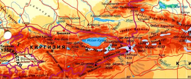
The Tien Shan mountain system stretches from west to east in Central Asia and passes through the territory of Kyrgyzstan, Uzbekistan, Kazakhstan and China (in the Xinjiang Uygur Autonomous Region). Most mountain ranges and ridges extend in the latitudinal or sublatitudinal direction. Only in the central part of the system there is an exception - a powerful ridge, which is called the Meridional, it includes the highest peaks. The Pamir-Alai system connects the western ranges of the Tien Shan with the Pamirs. The northern border of the Western Tien Shan is considered to be the Ili, and the southern -. The limits of the Eastern Tien Shan are usually designated in the north by the Dzungarian basin, and in the south by the Tarim basin.
Determining the geological age of the Tien Shan, scientists attribute the formation of the rocks of this mountainous country to the end of the early and beginning of the middle Paleozoic (500-400 million years ago). This is evidenced by the nature of their fundamental folding: Caledonian in the north and predominantly Hercynian in other parts. Subsequently, this ancient mountain material, belonging to the Ural-Mongolian belt, turned into a plain - peneplain (very similar to the current Kazakh small hills), which again ascended to the clouds relatively recently - during the Alpine orogeny, which began 50 million years ago and continues to this day day. Local residents call the folded reliefs of the foothills quite expressively - “adyrs”, that is, “counters”. These reliefs are covered in layers above by typical Alpine folding of a later time, formed by tectonic processes. In the depths of the Tien Shan, these processes continue, and today up to 30-40 seismic events are recorded per year. Fortunately, they are all of a relatively low level of danger, but the Tashkent earthquake of 1966 shows: this is not a guarantee that this will always be the case. Almost all large and many small lakes of the Tien Shan, both in the valleys and in the highlands, are of tectonic origin. The formation of mountains and gorges was, of course, influenced by erosion processes: outcrops and removal of sedimentary rocks, erosion and displacement of river channels, accumulation of moraine deposits, etc. Mudflows in the gorges of the Tien Shan are a common occurrence, especially on the northern slopes Trans-Ili Alatau, which is why the city of Almaty (Alma-Ata) suffered more than once.
In terms of orography, which describes mountainous reliefs, the Tien Shan is most often divided into Northern, Western, Central, Internal and Eastern. Sometimes clarifying adjustments are made to this terminology, for example, how the Southwestern Tien Shan, framing the Fergana Valley, is characterized as a special structure. Within the framework of the concepts of geomorphology, some individual ridges with unique structural features are also distinguished. Plus, there is also the Gobi Tien Shan on the territory of Mongolia - two relatively low (up to 2500 m) local ridges isolated from the Greater Tien Shan.
The highest peaks - Pobeda Peak (7439 m) and Khan Tengri (6995 m) - belong to the Central Tien Shan. The ridges of the Northern and Western Tien Shan gradually decrease from east to west from 4500-5000 m to 3500-4000 m. And the Karatau ridge rises only to 2176 m. Often the ridges have an asymmetrical outline. The Inner Tien Shan is dominated by the Terskey-Ala-Too, Borkoldoy, Atbashi ridges (up to 4500-5000 m) and the southern barrier - the Kokshaal-Too ridge (Dankova peak - 5982 m). In the Eastern Tien Shan, two stripes of ridges are clearly visible, Northern and Southern, again oriented along the West-East axis. They are separated by valleys and basins. The heights of the most massive ridges of the Eastern Tien Shan - Halyktau, Sarmin-Ula, Kuruktag - 4000-5000 m. At the foot of the Eastern Tien Shan there are the Turfan depression (depth up to -154 m), the Khamiya depression; The southern zone includes Lake Bagrash-Kol in the intermountain depression.
The Tien Shan rivers have the character of turbulent mountain streams, their average slope is 6 m per kilometer. The most productive river in terms of water energy is the Naryn, which at its confluence with the Kara Darya forms the Syrdarya. The Big Fergana and Northern Fergana irrigation canals originate from Naryn. On this river there is a cascade of hydroelectric power stations: Toktogulskaya, Tash-Kumyrskaya, Uchkurganskaya, Kurpsaiskaya, Shamaldysaiskaya, new cascade hydroelectric power stations are being built.
The first explorer of the Tien Shan was the Russian geographer and traveler P.P. Semenov (1827-1914), twice, in 1856-1857, the first European to climb the glacier of the Khan Tengri peak, awarded for his discoveries an honorary title addition to the surname - Tian-Shansky. Following him, expeditions to the Tien Shan were made by I.V. Ignatiev and his other students, as well as the Hungarian zoologist L. Almásy and the German geographer G. Mörzbacher.
Although the Tien Shan is the fifth highest mountain system in the world (after the Himalayas, Karakoram, Pamir and Hindu Kush), and its glacier-covered peaks look harsh, below the snow line the Tien Shan slopes represent a colorful and diverse natural world.
In the steppes of the foothills, ephemeral and ephemeral plants predominate. They are replaced by tall forbs, including many grasses. Even higher, with increasing humidity, meadows begin that serve as high-mountain summer pastures (jailau), islands of shrubs (saxaul, conifer, kopeck, juzgun) and deciduous forests, dominated by wild fruit trees. Above 2000 m above sea level. m. coniferous tracts begin, dominated by Tien Shan spruce and fir. Behind them begins a zone of alpine and subalpine meadows; they rise to heights of 3400-3600 m, mainly on the northern slopes. Gradually they are replaced by syrts - dry rocky plains with a wavy surface and small lakes. The most common type of vegetation on syrts is the so-called cushion plants, sort of short-stemmed balls that are resistant to temperature changes and strong hairdryer winds blowing from the peaks. Here, already on takyr-like soils, vast areas of permafrost often catch the eye as harbingers of a meeting with glaciers. Well, behind them rise ridges of low slate rocks and stretch out snow fields adjacent to flat (at this level) peaks dissected by gorges.
In the valleys of the Western Tien Shan, rich in rivers and well protected from the north by high and monolithic mountain walls, mixed forests of walnut with cherry plum, buckthorn and apple trees grow in the undergrowth. The drier valleys and basins of the Inner Tien Shan at altitudes of 1500-2500 m have signs of typical rocky deserts and mountain steppes of Central Asia.
The fauna of the Tien Shan is no less rich. In the most general terms, it can be described as typical of Central Asia, and in addition, there are animals whose homeland is Siberia. Wild donkeys and goitered gazelles graze on the plains, and Altai mountain deer, wild Siberian goats and mountain sheep (argali) are often found higher up. Among other mammals, the typical inhabitants of the Tien Shan are the endemic Tien Shan (or white-clawed) brown bear, badger, leopard, lynx, wild boar, tolai hare, wolf, fox, marten, manul. Among the rodents - gopher, jerboa, gerbil, mole vole, wood mouse, Turkestan rat. In the mountain forests there are black grouse, wood grouse, partridges, snowcocks, and pheasants. Ducks, geese, swans, cranes, and herons live in the reed thickets along the river beds. And everywhere - lark, wheatear, bustard, sandgrouse, partridge, finch, eagles and vultures. Swans appear on the lake during spring migration. Reptiles are most often represented by the viper, copperhead, and patterned snake. Lizards are scurrying everywhere. Many lakes of the Tien Shan are rich in fish (osman, chebak, marinka and other species).
More exotic fauna is represented in Dzungaria, geographical and historical region in the north of the Xinjiang Uygur Autonomous Region of China. There you can still find a wild camel and three representatives of the one-hoofed class: the dzhigetai, the kulan and the wild Przewalski's horse, species that are almost completely exterminated in other regions of Central Asia. The tiger lives in the riverine thickets of Dzungaria, the Gobi brown bear is found in the mountains, and the red wolf is common.
As confirmed by archaeological excavations of mounds, the population of the Tien Shan, both sedentary and nomadic, wore to a greater extent Caucasoid than Mongoloid features until the appearance of the Huns from the east and the Sarmatians from the west in the 6th-8th centuries, the Uyghurs in the 9th century, the Mongols, starting from the 12th century. The modern ethnographic map of the Tien Shan is mosaic, it is formed by dozens of ethnic groups. Hence the large number of customs, rituals, and legends preserved since ancient times. But in general, as travelers testify, in this world there is fidelity to its roots and wise tranquility, and it is extremely interesting to get acquainted with the local foundations of people’s lives.

general information
Nationality: Kyrgyzstan, Kazakhstan, Uzbekistan, China (Xinjiang Uyghur Autonomous Region).Ethnic composition: Uighurs (Kashgarians), Kazakhs, Kyrgyz, Mongols, Hui (Dungans), Chinese, Uzbeks, Tajiks, Oirats (Western Mongols), etc.
Religions: Islam, Buddhism, Hinduism.
Highest Peaks: Pobeda Peak (or Tomur in Uyghur) (7439 m), Khan Tengri (7010 m with glacier, 6995 m without glacier).
Largest ridges: Meridional, Terskey Ala-Too, Kokshaal-Too, Khalaktau, Boro-Khoro.
The largest rivers: Naryn, Karadarya (both belong to the upper reaches of the river basin), Talas, Chu, Ili.
Largest lake: Issyk-Kul (area - 6236 km 2).
Other large lakes(at an altitude of more than 3000 m above sea level): Son-Kol and Chatyr-Kol.
Largest glacier: Southern Inylchek (area - 59.5 km 2).
The most important passes: Turugart (3752 m), Muzart (3602 m), Tyuz-Ashuu (3586 m), Taldyk (3541 m), Boro-Khoro (3500 m).
Nearest airports(international): Manas in Bishkek (Kyrgyzstan), Tashkent South (Uzbekistan), Almaty in Almaty (Kazakhstan), Divopu in Urumqi (China).
Numbers
Length from west to east: about 2500 km.Average length(in this case - latitude) from north to south - 300-400 km.
Total area: about 875 thousand km 2.
Number of passes: more than 300.
Number of glaciers: 7787.
Total area of glaciers: 10.2 thousand km 2.
Climate and weather
In general, it is sharply continental.The Fergana ranges (Southwestern Tien Shan) are located on the border with a subtropical climate.
Average January temperatures: in the valleys of the lower mountain belt - +4°C, in mid-altitude valleys - up to -6°C, on glaciers - up to -30°C.
Average temperatures in July: in the valleys of the lower mountain belt from +20 to +25°С, in mid-altitude valleys - from +15 to +17°С, at the foot of glaciers from +5°С and below.
The temperature drop with every 100 m rise is approximately 0.7°C in summer; 0.6°C in autumn and spring; 0.5°C in winter.
Average annual precipitation: from 200 to 300 mm on the eastern slopes and valleys of the Inner and Central Tien Shan, up to 1600 mm in mid-mountain and high-mountain zones.
Economy
Minerals: ores of various non-ferrous metals, mercury, antimony, phosphorites (Karatau), hard and brown coal. In the Fergana Valley and the Dzhungar Basin there are deposits of oil and natural gas of industrial importance. The Tien Shan is also rich in geothermal springs.Agriculture: growing wheat, grapes, fruits, vegetables, sheep breeding, goat breeding, horse breeding.
Service sector: tourism.
Attractions
■ Peaks: Pobeda Peak on the border of Kyrgyzstan and China, Khan Tengri on the border of Kazakhstan, Kyrgyzstan and China.■ Lake Issyk-Kul(Kyrgyzstan).
■ High mountain lake Tianchi(“Heavenly”), China.
■ Valley of the sacred springs Manzhyly-Ata(Kyrgyzstan) - a place of Muslim pilgrimage to the mazar of the Sufi and preacher, after whom the valley is named.
■ Rock “walls” in the Lyaylyak river basin(Kyrgyzstan): Ak-Su (5355 m), Blok (5299 m), Iskander (5120 m).
■ National parks: Ugam-Chatkal (Uzbekistan), Ala-Archa (Kyrgyzstan).
■ Reserves: Issyk-Kul and biosphere Sary-Chelek in Kyrgyzstan, Alma-Ata and Aksu-Zhabaglinsky in Kazakhstan, Sary-Chatkal mountain forest in Uzbekistan, as well as a number of reserves (including in the territory of walnut-fruit forests of the South-Western Tien- Shan), the Altyntag reserve and the “landscape area” “Mountain Screen” (China).
Curious facts
■ Pobeda Peak, named so in 1946 in honor of the victory Soviet Union in Great Patriotic War, is one of the seven-thousanders for which climbers are awarded the prestigious title “snow leopard.”■ During sunset, part of the Khan Tengri peak becomes almost scarlet, like the shadows of clouds near it. This is where its second, “folk” name comes from - Kan-Too, or Kan-Tau, meaning “bloody (or bloody) mountain” (from the Turkic “kan” - “blood”, “too” - “mountain”), In this there is a certain sacred meaning: the sharp, blade-like and inaccessible peak of Khan Tengri is associated among the indigenous inhabitants of the Tien Shan with the concepts of “homeland” and “struggle”.
■ The northern slope of Khan Tengri Peak (6995 m), its western bridge (5900 m), connecting it with Chapaev Peak (6371 m), resemble the configuration of the Himalayan ligament Chomolungma (8848 m) - its South Col (7900 m) - and the peak Lhotse (8516 m). And although the Tien Shan “understudy” is 2 km lower, climbers planning to storm the highest peak of the world The final stage preparations for this expedition are carried out here.
■ In the wreath of legends about Lake Issyk-Kul there are stories that at its bottom there is a flooded Armenian monastery where the relics of the Apostle Matthew were kept. Several legends tell about Tamerlane's stay here. But most of the legends are associated with the shed hot (Turkish, “issyk”) tears of the young beauty Cholpon. She cried for so long that her tears formed a lake as beautiful as herself. In one of the legends, it is not she who cries, but the people for her. Two warriors who claimed her heart - Ulan and Santash - entered into a life-and-death battle. But their strength was equal, and all their relatives went wall to wall. Cholpon could not stop them, and then she tore her heart out of her chest. The opponents froze, and then they all took Cholpon to high mountain, laid her face to the sun and began to mourn her. Their tears, flowing in streams, flooded the valley between the mountains.
Tien Shan or " Heavenly Mountains» - one of the highest and most visited mountain systems by tourists throughout the CIS countries. This grandiose mountainous country located mainly in the western part Kyrgyzstan a and on eastern China. Its northern and northwestern ranges reach Kazakhstan a, and the southwestern spurs ran through the territories Uzbekistan a And Tajikistan a. Thus, throughout the post-Soviet space, Tien Shan mountains stretched in a kind of arch, more than 1200 km in length and almost 300 km in width.
Scientists attribute Tien Shan to fairly old mountains of the Caledonian and Hercynian folding period, which underwent subsequent uplift in the Alpine era.
However, it must be said that the tectonic activity of this mountain system continues today, as evidenced by its high seismic activity.
Many glaciers give rise mountain rivers - tributaries of Naryn like a river going down a huge staircase from Tien Shan, covering 700 km of travel and gaining gigantic power. It is not surprising that the number of large and medium-sized power plants built on Naryn e, exceeds ten.
Remarkable in beauty Tien Shan lakes, and its main pearl - Issyk-Kul, which occupies a giant tectonic depression between mountain ranges Kungey- And Terskey-Alatau. Its maximum depth reaches 702 m, and the water surface area is 6332 sq. m. The lake is the seventh largest and third deepest natural reservoir in the entire post-Soviet space.
The most significant lakes of the Inner Tien Shan are also Song Kel And Chatyr-Kel, by now, considered to be drying up. On the territory of the Syrts and in the zone of low moraine relief there are quite a lot of small lakes; in the highlands there are glacial and subglacial reservoirs, they are interesting in themselves, but of no serious significance for the climate Tien Shan don't imagine.
Mountaineering potential of the Tien Shan.
Central Tien Shan.
Two areas stand out here - glacier areas South Inylchek And Kaindy.
South Inylchek.
It is located in the extreme eastern part of the country, on the border with Kazakhstan om And China, and includes eastern slopes of the Kokshaltau ridges, Inylchek-Tau, Saryjaz, and Tengri-Tag ridges And Meridional. This area is home to one of the largest glaciers in the world - South Inylchek, the length of which is 62 km, and the width reaches 3.5 km, with an average thickness of ice up to 200 m. There are also two " seven thousandths» peaks- Pobeda Peak And Khan Tengri Peak, 23 peaks over 6000m and about 80 peaks with a height of 5000-6000m. There are more than 70 routes in the area, but two “ six thousandths"tops and about 20" five thousand meters"remained unconquered.
Tagged mountainous areas Almost never visited by climbers and still fraught with great prospects for pioneers.
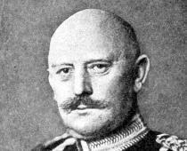
I. A. Cherepov
Mysteries of the Tien Shan
(From the history of the discovery and conquest of Pobeda Peak. A. Letavet’s expeditions of 1937–1938)
Inaccessible mountain steeps, always snow-covered, with almost sheer slopes, the highest peaks piercing their sharp peaks into the blue sky, harsh glaciers and snowstorms have protected the geographical mysteries of the Tien Shan for many centuries.
The honor of studying this mountainous country belongs to our domestic science.
The first explorer of the Tien Shan was the famous Russian geographer P.P. Semenov-Tyan-Shansky, who penetrated into the very heart of the Heavenly Mountains, to the Tengri-Tag massif. Following P.P. Semenov-Tian-Shansky, this little-studied region of the country was explored by N.A. Severtsov, I.V. Mushketov, I.V. Ignatiev and other Russian scientists, who with their works made an invaluable contribution to the study of the Tien Shan. But, not having the means to organize large expeditions and not receiving support from the tsarist government; lone explorers could not penetrate the remote areas of this mountainous country.
The Great October Socialist Revolution radically changed the life of the peoples of the former Tsarist Russia. In the Soviet Union they reached their peak National economy, science, culture. From the first days Soviet power scientists of our country were provided with comprehensive government assistance; hundreds of large scientific institutions, large complex expeditions were organized to study many regions of our great Motherland.
Soviet people also came to the peaks of the Tien Shan. Neither stormy rivers nor high mountain ranges stopped them - they penetrated the kingdom of eternal winter and tore off the mysterious covers from the mountain giants.
The discovery in 1943 of Pobeda Peak, the main peak of the Tien Shan with a height of 7439 m, was one of the largest geographical discoveries the last twenty years.
In this book, the author, a participant in the Tien Shan expeditions of Professor A. A. Letavet, talks about how a group of Soviet scientists and climbers, having penetrated into the unexplored high-mountain regions of the Soviet Tien Shan, solved its geographical mysteries and thereby helped Soviet researchers discover Pobeda Peak .
The book consists of two parts: “Part I. The peak of the Stalinist Constitution” and “Part II. Pobeda Peak." They are preceded by an Introduction, briefly outlining the history of the development of the Tien Shan and reminding the reader of the orography of this most interesting region of our Motherland.
The author takes this opportunity to express great gratitude to his companions and comrades on high-mountain expeditions in the Tien Shan, Professor A. A. Letavet, V. F. Mukhin, E. I. Ivanov, A. V. Bagrov and E. M. Kolokolnikov, for their help in working on the book.
I. Cherepov.
Introduction
The vast mountainous country of Tien Shan lies in the very heart of Asia. Its mountain ranges stretch from west to east for more than two and a half thousand kilometers.
The spurs of the westernmost ranges of the Tien Shan - Talas, Chatkal, Fergana and Kuramin descend to the capital of the Uzbek SSR, the city of Tashkent. The Fergana, Chatkal and Kuramin ridges enclose the Fergana Valley from the north. The eastern spurs of the Tien Shan ranges reach the western edge of the Gobi Desert.
A characteristic feature of the Tien Shan is the latitudinal elongation of both the entire mountain region as a whole and most of its mountain ranges and ridges. In the meridional direction from north to south, the boundaries of the region extend only 300–400 km, and all of it fits within 40–44 degrees. northern latitude.
In the south, the Tien Shan is separated from the mountainous regions of Kunlun and Altyn Tag, adjacent to Tibet, by the wide sandy Taklamakan desert. The Western Tien Shan is connected with the Pamirs by the Pamir-Alai mountains; The border between them is the fertile Fergana Valley.
The high, ever-snowy ranges of the Soviet Tien Shan feed many large rivers Central Asia- Or, Chu, Naryn (upper reaches of the Syr Darya), Ak-sai, Uzengegush, Sarydzhas, Tekes. Common feature All drainages of the Tien Shan is that not a single drop of their water reaches the ocean, feeding the internal basins of rivers and lakes in Central Asia.
The entire mountainous region of the Tien Shan is usually divided into four parts. The Western Tien Shan includes mountain ranges and ridges located to the west of Lake Issyk-Kul. The Central Tien Shan includes the highest ridges of the mountain region located to the south of Lake Issyk-Kul, as well as to the east of it all the ridges up to and including the Meridional. The Kungei and Zailiysky ridges, located north of Lake Issyk-Kul, rise in the Northern Tien Shan. To the northwest of the Trans-Ili Ala-Tau rise. Chu-Ili mountains. The Western, Central and Northern Tien Shan are located on the territory of the Soviet Union.
The Eastern Tien Shan includes all mountain ranges located to the east of the Meridional Range and located mostly on the territory of the western provinces of the People's Republic of China.
The Western Tien Shan is a widely branched system of mountain ranges and ridges located mainly on the territory of the Kyrgyz and partially Kazakh and Uzbek union republics. These include the Kyrgyz, Talas, Chatkal, Fergana, Kurama and a number of smaller ridges and their spurs, located over a wide area from west to east from Tashkent to Lake Issyk-Kul and from north to south, from the Ili River valley to the Fergana Valley.
In the Western Tien Shan, in the wide valley of the Chu River, the capital of the Kirghiz SSR is located - the city of Frunze. The ridges of the Western Tien Shan are relatively accessible and explored. In terms of mountaineering, the most studied is the Kyrgyz Ala-Tau, whose ever-snowy peaks have been climbed many times. Soviet climbers also visited the peaks of the Chatkal ridge more than once.
North of Lake Issyk-Kul, on the territory of the Kazakh SSR, there are two mountain ranges of the Northern Tien Shan, Zailiysky Ala-Tau and Kungei. Ala-Tau, connected with the Chiliko-Kemin mountain cluster into one powerful mountain system On its northern slopes, facing the Ili River valley, lies the capital of Kazakhstan - the city of Alma-Ata. The part of the Trans-Ili Ala-Tau adjacent to the capital is the most studied and developed by climbers.
Several mountaineering camps operate in this area, numerous peaks have been climbed, and the training of Central Asian mountaineers is mainly concentrated here.
Tien Shan is a majestic mountain system located in the heart of Asia. Some of the largest slopes in the world, with meadows filled with thousands of wildflowers, waterfalls, deserts and steppes located at the foot. All this creates indescribable beauty and gave rise to the name: translated it means “Heavenly Mountains”. In order to understand where the Tien Shan Mountains are located, you just need to look at the atlas: they pass through the territory of 5 countries in the eastern part of the continent: China, Kazakhstan, Kyrgyzstan, Uzbekistan and Tajikistan.
Facts and figures
The mountain system stretches for as much as 2,500 km, the position of which creates a unique composition of more than 30 peaks, many of which rise to the clouds at least 6,000 meters. The highest point is the Pobeda Peak mountain - 7439 m, which takes place on the border of two countries: the Chinese state and the Kyrgyz state. The second highest mountain is Khan Tengri Peak (6995 m), separating China, the lands of Kazakhstan and the outskirts of Kyrgyzstan.
Location of the mountain system
The Tien Shan is a powerful high-mountain system of the planet, one of the largest on the planet, located in the central areas of Asia. The predominant part of the Tien Shan lies on the lands of modern Kyrgyzstan and China, but some mountain branches cover the territory of other countries: the southwestern ones lie in Uzbekistan and the vast expanses of Tajikistan, and the northern and remote territories of the west are located within the borders of Kazakhstan.
Coordinate data of the Tien Shan, based on geographical sources: 42 degrees and 1 minute north latitude and 80 degrees and 7 minutes east longitude.
Relief and geographical zoning
The chains of mountains are quite branched and have the names Inner and Eastern massifs, Northern region, ridges of the western Tien Shan, Central. Each region is branched into several mountain ranges.
All ridges are divided among themselves by intermountain deep canyons with charming picturesque landscapes and lakes.
The highest point among the Tien Shan mountains
Pobeda Peak is located on the lands of Kyrgyzstan, close to the border of China and belongs to the category of the highest points in the world (7439 meters). Presumably, tourists first conquered this peak in 1938, and five years later in honor of the victory over German fascist invaders near Stalingrad, an expedition of climbers was sent to the mountain by the main leadership of the USSR. In 1995, two groups left to climb different routes. One of them is from Kazakhstan, the second from Uzbekistan. Having risen to 6000 m, the first of them, due to bad weather conditions, was forced to stop the ascent and begin the descent; only one of the 12 members of the group survived. Since that time, the mountains have had a bad reputation; they are mainly conquered by daredevils from Russia or the CIS countries.

An interesting story about Zhang Cang, who, in a detachment of 100 people, first set out on the orders of Emperor Wu DI through the passes back in 138 BC. AD to meet the allies, but was captured, where he remained for 10 years. An accident helped Zhang escape, and he carefully described his long travels across the Northern Tien Shan and the lands of Asia, brought information to China, and following his steps, the famous Great Silk Road was created, along which they began to export silk to the Roman Empire.
Geology and structure
The Tien Shan is part of the Ural-Mongolian (Ural-Okhotsk) folded geosynclinal belt. Mountain ranges are formed by igneous rocks, and intermontane depressions are formed by sedimentary rocks. The high-mountainous terrain is characterized by glaciations of various forms.

The formation of the massifs that create the current high-mountain relief began in the Oligocene period, and mountain building became most active in the Pliocene and Anthropocene. The movement of tectonic plates, of a differentiated type, made the modern relief stepped, with powerful erosion, with the emergence of deep valleys near rivers and the appearance of glacial masses.
Minerals
The following minerals were discovered in the depths of the mountains: huge deposits of mercury ores and antimony, formations of cadmium and zinc, tin and tungsten. In the lower reaches of modern Tajikistan there are gas and oil fields. Profit copper and cobalt seams were also observed. In the Western environs of the Tien Shan massif, a gold-quartz formation was found. There are many industrial deposits of coal, marble, gypsum, limestone, as well as more than a hundred varieties of mineral waters.

It is known that the first mining began in the Tien Shan 5 thousand years ago, as evidenced by frescoes in caves and on rocks. During the Neolithic period, the mining of ocher, manganese ores and peroxide began. 2000 BC During the Bronze Age, copper ore, lead, zinc and tin were mined in the mountains; there are suggestions that the layers were rich in gold and silver, which was actively withdrawn at the same time. The development of antimony, clay, stone, sulfur and vitriol flourished for construction, but during the period of raids by the warlike Mongols in the 13th century, development fell into disrepair. Since then, archaeological scientists have found many picks, all kinds of clay shovels, and lamb skins used for washing gold.
Ancient and modern glaciation of the mountain system
The glaciation area is more than 7300 kW. km. and has 7,700 glaciers, which are divided into three groups:
- Valley;
- Hanging;
- Karovy.
The largest part of them is located in the Center of the Tien Shan Range. It is there that the largest Inylchek glacier is located - its length is as much as 60 km. The formation of ice blocks in the foothills occurs continuously, i.e. New growths quickly form in place of the separated layers.
In the era when it was necessary glacial period the entire system of mountains was surrounded by a thick ball of ice, this is still evidenced by ramparts, moraines, cirques, and icy lakes.
An interesting fact is that all the rivers of Central Asia are fed by Tien Shan glaciers. Descending from the hills in a strong stream, they form the largest river - Naryn and its numerous tributaries. The flow of the river even made it possible to create an entire system of hydroelectric power stations in Naryn.
Unfrozen lake
The deepest large lake, Issyk-Kul, was formed in a tectonic fault. His very deep place 668 m, which means it is third in the world after Baikal and the Caspian Lake. The position and waters significantly influence the climate in the region. Like other closed reservoirs, it contains salinity, which, according to experts, will increase. The lake is young, recently formed, so a large volume of water simply did not have time to accumulate salts. The reservoir is never covered with an ice crust, unlike other lakes in the foothills of the Tien Shan, which are bound by glaciers almost all year round.
The fauna of the lake is poor, but there are species of commercial importance. Available here and water transport, which runs from Rybachye station to the village. Przhevalsk.
In the summer heat, the azure-emerald clear waters of Issyk-Kul are a favorite vacation spot for many tourists.

Climate and natural conditions
The mountains will greet you with a harsh continental climate, characterized by strong differences in night and day temperatures, weak gusts of wind and dry air. Winters here are frosty and harsh, summers are hot in the valleys, and cool and comfortable on the peaks. The sun shines predominantly on the mountain slopes, and the average number of hours it shines is about 27 thousand hours per year. For comparison, in the capital of Russia this figure is lower and equal to 1600 hours per year.
The formation of climate is mainly influenced by the difference in heights of the Tien Shan ridges, lakes and features of the land and relief. Cloudiness and precipitation intensity increase with increasing altitude: the least amount of precipitation falls on the plains - about 200 mm per year, while in the middle mountains the value is narrower - 800 mm. The summer and spring periods have the greatest amount of snow and rain.

The snow layer is not the same everywhere. In the north-west it begins to form at around 3600 m, in the east – 4000 m, and in the central regions – 4500 m. The western mountain ranges are mostly devoid of snowfall and are actively used by mountain residents for winter grazing.
Although there is a high probability of avalanches during the warm period, this best time for a trip to the Tien Shan mountains, since for most Europeans the harsh winter climate is difficult to endure.
Animals and plants
The fauna consists of inhabitants of the steppe and desert zones. The most common ones include the goitered gazelle, ground squirrel, stomping hare, common jerboa, gerbil, and others. Of the reptiles, the most common are lizards, species of vipers and snakes. In the vastness of the Tien Shan, flocks of eagles, melodious larks, bustards, and partridges have found their home.
In the areas of the middle mountains live wild boars, flocks of wolves and foxes, representatives of bears and lynxes, nutcrackers and crossbills fly.
The geography of the inhabitants at the peak points of the mountains changes: stoats, colorful argali, populations of mountain goats and the very rarely seen beautiful snow leopard live here. Among the birds - vultures, eagle families, jackdaws, larks.
Ducks, geese, swans, storks and other waterfowl are common only in the vastness of mountain lakes.
Mountain steppes on well-warmed slopes are densely covered with turf and feather grass mixed with exposed stone screes. In summer, wormwood, thyme, and ephedra begin to grow. The Central Tien Shan is more diverse; more than 30 species of grass grow in its steppe areas.
Mountain tourism
Clean, almost alpine air, magnificent landscape and picturesque views attract lovers of active sports recreation. Every professional climber and ski enthusiast should visit the Tien Shan mountain system at least once. The diverse slopes have long been dotted with various resorts, where slopes are equipped for skiing and skiing for professionals and entry-level athletes, there is equipment rental and experienced instructors who will help you get started on skis or snowboards for the first time. The season starts north in early December and continues until the last days of March. The best month for skiing is February.

In the highlands, where snow lies almost all year round, it is a paradise for mountaineering athletes. For them, ascents to glacial areas and peaks are realized; access to high points by car or approach by air is possible.
Take a look at the resorts "Oru-Sai", the snowy "Kashka-Suu", the high-mountain "Orlovka" and the city of "Karakol" - they are the most popular.
Results
The Tien Shan range is a unique, stunningly beautiful mountain system, one of the highest and longest in the world, full of extraordinary flora and fauna, and diverse mineral deposits. This is a popular place among tourists interested in active recreation and sports. There are various resort towns and ski slopes on the slopes. The winter climate of the mountains is harsh, so travelers are advised to visit these places in spring and summer, when the formation of air masses is not so intense and sunny days. The height of the Tien Shan mountains forms several tiers - foothill, middle and high mountain, each of which has its own characteristics of climate, animal and flora, landscape.
History of the discovery of the Tien Shan peaks
Inaccessible mountain steeps, always snowy, with almost sheer slopes, the highest peaks piercing their sharp peaks into the blue sky, harsh glaciers and snowstorms have protected the geographical mysteries of the Tien Shan for many centuries.
The honor of studying this mountainous country belongs to our domestic science.
The first explorer of the Tien Shan was the famous Russian geographer P.P. Semenov-Tyan-Shansky, who penetrated into the very heart of the Heavenly Mountains, to the Tengri-Tag massif. Following P.P. Semenov-Tyan-Shansky explored this little-studied area of the country by N.A. Severtsov, I.V. Mushketov, I.V. Ignatiev and other Russian scientists, who with their works made an invaluable contribution to the study of the Tien Shan. But, not having the means to organize large expeditions and not receiving support from the tsarist government; lone explorers could not penetrate the remote areas of this mountainous country.

The Great October Socialist Revolution radically changed the life of the peoples of former Tsarist Russia. In the Soviet Union, the national economy, science, and culture reached their peak. From the first days of Soviet power, scientists in our country were provided with comprehensive government assistance; hundreds of large scientific institutions were created; large complex expeditions were organized to study many regions of our great Motherland.
Soviet people also came to the peaks of the Tien Shan. Neither stormy rivers nor high mountain ranges stopped them - they penetrated into the kingdom of eternal winter and tore off the mysterious covers from the mountain giants.
The discovery in 1943 of Pobeda Peak, the main peak of the Tien Shan with a height of 7439 m, was one of the largest geographical discoveries of the last twenty years.

Pobeda Peak
The vast mountainous country of Tien Shan lies in the very heart of Asia. Its mountain ranges stretch from west to east for more than two and a half thousand kilometers.
The spurs of the westernmost ranges of the Tien Shan - Talas, Chatkal, Fergana and Kuramin descend to the capital of the Uzbek SSR, the city of Tashkent. The Fergana, Chatkal and Kuramin ridges enclose the Fergana Valley from the north. The eastern spurs of the Tien Shan ranges reach the western edge of the Gobi Desert.
A characteristic feature of the Tien Shan is the latitudinal elongation of both the entire mountain region as a whole and most of its mountain ranges and ridges. In the meridional direction from north to south, the boundaries of the region extend only 300-400 km, and all of it fits within 40-44 degrees. northern latitude.
From the south, Tien Shan is separated from the mountainous regions of Kunlun and Altyn Tag, adjacent to Tibet, by the wide sandy Taklamakan desert. The Western Tien Shan is connected with the Pamirs by the Pamir-Alai mountains; The border between them is the fertile Fergana Valley.
The high, ever-snowy ridges of the Soviet Tien Shan feed many large rivers in Central Asia - the Ili, Chu, Naryn (upper reaches of the Syr Darya), Ak-sai, Uzengegush, Sarydzhas, Tekes. A common feature of all Tien Shan drainages is that not a single drop of their water reaches the ocean, feeding the internal basins of rivers and lakes in Central Asia.

The entire mountainous region of the Tien Shan is usually divided into four parts. The Western Tien Shan includes mountain ranges and ridges located to the west of Lake Issyk-Kul. The Central Tien Shan includes the highest ridges of the mountain region located to the south of Lake Issyk-Kul, as well as to the east of it all the ridges up to and including the Meridional. The Kungei and Zailiysky ridges, located north of Lake Issyk-Kul, rise in the Northern Tien Shan. To the northwest of the Trans-Ili Ala-Tau rise. Chu-Ili mountains. Western, Central and Northern Tien Shan are located on the territory of the Soviet Union.
The Eastern Tien Shan includes all mountain ranges located to the east of the Meridional Range and located mostly on the territory of the western provinces of the People's Republic of China.
The Western Tien Shan is a widely branched system of mountain ranges and ridges located mainly on the territory of the Kyrgyz and partially Kazakh and Uzbek union republics. These include the Kyrgyz, Talas, Chatkal, Fergana, Kurama and a number of smaller ridges and their spurs, located over a wide area from west to east from Tashkent to Lake Issyk-Kul and from north to south, from the Ili River valley to the Fergana Valley.
The ridges of the Western Tien Shan are relatively accessible and explored. In terms of mountaineering, the most studied is the Kyrgyz Ala-Tau, whose ever-snowy peaks have been climbed many times. Soviet climbers have also visited the peaks of the Chatkal ridge more than once;
To the north of Lake Issyk-Kul, on the territory of the Kazakh SSR, there are two mountain ranges of the Northern Tien Shan, the Trans-Ili Ala-Tau and the Kungei. Ala-Tau, connected with the Chiliko-Kemin mountain cluster into one powerful mountain system. On its northern slopes, facing the Ili River valley, lies the capital of Kazakhstan - the city of Alma-Ata. The part of the Trans-Ili Ala-Tau adjacent to the capital is the most studied and developed by climbers.
Several mountaineering camps operate in this area, numerous peaks have been climbed, and the training of Central Asian mountaineers is mainly concentrated here.
The Central Tien Shan includes the highest mountain ranges and ridges. Here is the area of the most powerful glaciation.
South of Lake Issyk-Kul, on the territory of the Kyrgyz SSR, there are two large mountain ranges of the Tien Shan - Terskey Ala-tau and Kok-shaal-tau

Terskey Ala Tau
Between them, on a vast highland, there are several smaller ridges Naryn-tau, At-bashi, Ak-shiyryak, Chakyr-korum, Borkoldoy and others.
Kokshaal-tau is the southernmost and, perhaps, least studied and developed by climbers ridge of the Tien Shan with peaks of about 6000 m (Kzyl-Asker 5899 m, Dankov Peak 5978 m, Alpinist Peak 5782 m, etc.).

Kok Shaal Tau
In terms of height, shape of the peaks and inaccessibility, this entire area is of very great scientific and sporting interest, so it attracts the attention of researchers and climbers.
To the east of Lake Issyk-Kul is the highest and most inaccessible part of the entire Tien Shan - the Khan Tengri massif. The largest (60 km) glacier of the Tien Shan - South Inylchek - is located here. There are many peaks in this area above 6000 m, the highest of which are Khan Tengri - 6995 and Pobeda Peak - 7439 m, the second highest mountain peak in the Soviet Union. The northernmost ones globe the peaks are seven thousand meters, covered with masses of ice and snow; they, naturally, give rise to the most severe conditions and special inaccessibility. Many centuries ago, people passed by these mountains, saw a cluster of eternal snow giants from afar, but could not get close to them. Therefore, human imagination populated them with mysterious spirits and gave them appropriate names. Thus, the entire mountainous region is called Tien Shan, which in Chinese means “Heavenly Mountains”, the Khan-Tengri massif has the local name Tengri-tag translated from Uyghur - “mountains of spirits”, and the top of the massif acquired the name Khan-tengri. Tengri - in Russian "Lord of Spirits".

Khan Tengri
The Khan Tengri massif, consisting of a number of ridges and peaks, occupies the eastern part of the Central Tien Shan and until recently attracted the attention of scientists and climbers, promising them a lot of unknowns. The peaks of its ridges are extremely numerous, and the ascents made in this massif can be counted on one hand.
The orographic structure of the Khan Tengri massif is very unique. In its eastern part there is the Meridional Ridge, which crosses this part of the Central Tien Shan from north to south. From this ridge, in the latitudinal direction, the highest ridges of the Tien Shan extend to the west - the Stalin ridge, Sarydzhas, Boz-kyr (Eastern Kok-shaal-tau); to the east - Severny and Halyk-tau.
The Terskey Alatau ridge extends from the Sary-Dzhas ridge to the northwest, and the Kuylyu-Tau ridge serves as a continuation of the Sary-Dzhas ridge in the west. From the Boz-kyr ridge the Inylchek-tau ridge branches off to the west and from it, in turn, the Kaindy-katta ridge branches off.
The highest peaks of the massif stand near the Meridional Ridge and on it itself. Pobeda Peak rises in the Boz-kyr ridge, and to the north of it, in the Stalin ridge, stands Khan Tengri Peak.
The South Inylchek glacier flows west from the Meridional Ridge and receives tributary glaciers from the slopes of the Stalin, Sary-jas, Boz-kyr and Inylchek-tau ridges.
There are many forests in the Tien Shan. High mountain valleys, plateaus and mountain slopes are covered with lush grasses. Rich herds of collective and state farms graze on mountain pastures. The abundance of wild animals - mountain goats (tau-teke) and sheep (argali) - creates favorable conditions for the widespread development of hunting. Many minerals have been explored in the depths of the Tien Shan, promising broad prospects for the development of the mining industry.
The proximity of the snowy Tien Shan ranges to the capitals of the Kazakh and Kyrgyz Union Republics provides a wide field of activity for the development of mountaineering, one of the favorite sports of the brave. Soviet people- this unique school of courage. The governments of Kazakhstan and Kyrgyzstan pay due attention to the development of mountain sports in the republics; mountaineering in the area of the Trans-Ili Ala-Tau ridge, near the city of Alma-Ata, ranks second after the Caucasus, and climbers of Kyrgyzstan have become famous for holding alpiniads - mass mountaineering training trips.
In the area of the Khan Tengri massif, on an area of about 10,000 square meters. km concentrated the highest peaks and the largest glaciers of the Tien Shan. Deep valleys separate the ridges. Their powerful glaciations are often associated with common firn basins.
The inaccessibility of the Khan Tengri region delayed its exploration for a long time. People did not go deep into this kingdom of eternal winter and told tales and legends about the mysterious country of Tengri Tag.
Only in 1856-1857. the great Russian geographer P. Semenov managed to lift the veil of mystery that covered this part of the Tien Shan. He was the first explorer to see Tengri Tag and set foot on its glacier. The remarkable description of his journey to the Tien Shan that he compiled still serves as an example of the work of scientific thought and amazes with the clarity and breadth of observations and conclusions.
Unfortunately, P.P. Semenov did not go into the depths of the Khan Tengri massif, and this area, until very recently, kept many mysteries. P.P. Semenov visited the Tien Shan only twice, but during his further activities he sent many Russian scientists there who continued his work. In 1886, I.V. Ignatiev visited the Tien Shan with the special purpose of penetrating the Khan Tengri massif. In addition to the Semenov and Mushketov glaciers, flowing north from the Sarydzhas ridge, I.V. Ignatiev was in the Inylchek valley, but did not reach the huge glacier lying in this valley. Without special equipment, he was unable to overcome the stone cover of his twenty-kilometer surface moraine. Other researchers of the Tien Shan were also frightened for a long time by its inaccessibility. The glory of the entire massif, especially the Khan Tengri peak, attracted several foreign scientists and climbers to it, but they also failed to unravel its secrets. Thus, in 1899, the Hungarian zoologist Almásy went to the Sary-Dzhas valley, but he failed to unravel the complex orography of the Khan Tengri massif. The following year, Swiss guides appeared with the Italian climber Borghese, but they were unable to climb the Inylchek glacier, which seemed impassable to them.
In 1902, a famous researcher of the Altai and Tien Shan mountains, professor of botany V.V. Sapozhnikov, was in this area. He did not limit himself to working in his specialty, but, in the tradition of famous Russian travelers; covered a very wide area of research, made measurements of many peaks of the Khan Tengri massif, climbed glaciers and passes.
He determined the height of the Khan Tengri peak at 6950 m, reducing its actual height by only 45 m, and did this much more accurately than many previous and subsequent researchers.
V. at the same time, in 1902-1903. The Khan Tengri massif was visited by the German geographer and mountaineer Merzbacher. He managed to make several ascents to minor peaks and even walk the South Inylchek glacier to the foot of the Khan Tengri peak, the height of which he determined to be 7200 m. This scientist took overview photo panoramas and wrote up descriptions of the places he actually visited. But, unfortunately, he put some of his hypotheses and assumptions, which were later refuted by reality, on a par with facts. This caused great confusion in the orography of the Tien Shan, which Soviet scientists and climbers had to understand and put in final order.
To solve many of the mysteries of the Tien Shan, Soviet scientists and climbers penetrated deep into the Khantengri massif and overcame all its difficulties and dangers. Merzbacher justified his failures by saying that “the high peaks of the Tien Shan are an unsuitable place to satisfy the love of mountaineering.” Soviet climbers were able to prove that they do not single out the love of mountaineering as something self-sufficient, but always subordinate it to the main tasks set for the development of the Soviet physical education movement. Very often they use their mountaineering activities to serve research purposes. And if we talk about the love of sports, the satisfaction that athletes receive from mountaineering, or the fact that they are attracted to high and harsh mountains, then Soviet climbers have their own standard for this. They get more satisfaction the more difficult the climb was, the higher and more inaccessible the peak was, the more they collected interesting information for scientists, the more obstacles were encountered and overcome, the more friendly and stronger the team was, p. who share the joy of victory.
Much work on the study of the Tien Shan was carried out by Soviet scientists and climbers in a very short period. In 1929, the map of the Tien Shan was still full of blank spots, which had to be filled in by subsequent expeditions, specially prepared and equipped for work on glaciers and peaks.
Soviet climbers came to the Tien Shan together with scientists and entered its unexplored areas not only for sporting purposes. They solved scientific research problems, unraveled the complex orography of the region, studied glaciation, and compiled maps.
M. T. Pogrebetsky, now an Honored Master of Sports in mountaineering, headed the organization of the Ukrainian expedition to the Tien Shan, which worked in the Tengri Tag region for a number of years - from 1929 to 1933. At first it was a mountaineering sports group. It later grew into a comprehensive Ukrainian government expedition that did a lot of topographic survey work; geological exploration and geographical study of the Khan Tengri massif.
Pogrebetsky set the main sporting goal of his mountaineering group to climb Khan Tengri Peak. After two years of work on Inylchek, detailed reconnaissance of approaches and study of the route, on September 11, 1931, the Lord of Spirits was defeated. Soviet climbers climbed to its peak, dispelling the myth of the inaccessibility of Khan Tengri and conquering the first seven-thousandth peak. Soviet Union Pogrebetsky's group made this remarkable ascent along a route laid from the South Inylchek glacier.
In 1929-1930 on the other side of the Stalin Ridge, from the Northern Inylchek glacier, Khan Tengri was stormed by Moscow climbers V.F. Gusev, N.N. Mikhailov and I.I. Mysovsky. They were the first to lead horses to the South Inylchek glacier. However, in 1929 they were stopped by Lake Merzbacher, which separates the tongue of the North Inylchek glacier from the South Inylchek glacier, and they decided to change their route. In 1930, they found a pass in the Sary-Dzhas ridge (Soviet Press Pass) and passed through it to the Northern Inylchek glacier, explored it and explored the approaches to Khan Tengri. The following year, G.P. Sukhodolsky’s group went to the Northern Inylchek glacier through Lake Merzbacher, using a rubber inflatable boat, and along its rocky shores. The group climbed from the north onto the slopes of Khan Tengri to an altitude of about 6,000 m, but retreated, making sure that there was no way to the top from this side. Having completed the reconnaissance task, she went downstairs.

Inylchek
In 1932, the work of Pogrebetsky’s expedition to Tengri Tag continued. At the same time, a mountaineering group from the Moscow House of Scientists under the leadership of Professor A. A. Letavet appeared for the first time in the Tien Shan. This small group, consisting of only 4 people, visited the sources of one of the main water arteries of Central Asia - the Syr Darya River, climbed Sary-tor (5100 m) - the main peak of the Ak-shiyryak ridge, then walked south to the sources Dzhangart River. Here Letavet and his companions saw large glaciers and groups of high and difficult peaks of the Kok-shaaltau ridge. From here, through another pass, through the Terskey Ala-tau ridge, they returned to Przhevalsk, then crossed the northern Tien Shan ridges of Kungei Ala-tau and Trans-Ili Ala-tau and ended their route in the city of Alma-Ata.
Thus, the group crossed the entire high-mountainous Tien Shan from south to north and, with this kind of reconnaissance, determined several of their routes for the future.
In the next two years, A. A. Letavet’s group visited the sources of the Uzengegush River, in the middle part of the Kokshaal-tau ridge. On the way to this southernmost and most remote ridge of the Tien Shan, the climbers climbed one of the peaks of the Borkoldoy ridge, near its junction with the Chakyr-korum ridge.
They entered this area by going to the sources of the Dzhagololamai River, and discovered there a kind of mountaineering reserve - a group of glaciers and peaks up to 4500m high (5200) "It was an incredible chaos of peaks and glaciers, especially at the junction of it (the Borkoldoy ridge.) with Chakyr -korum; the earth here seemed to bristle with an endless number of needles and thorns"
“Dry fog” - the dust of the Taklamakan desert - hung over the mountains and did not make it possible to examine the peaks of the Kok-shaal-tau ridge from afar, and A. A. Letavet’s group moved further to the Kubergenty pass. From this pass one could see the sources of the Uzengegush and Ak-Sai rivers, collecting their waters from the glaciers of the northern slopes of the Kokshaal-tau ridge, which rises here in peaks close to 6,000 m in height. Having examined this part of the ridge, the climbers mapped a number of glaciers and peaks, gave names to the nameless peaks Kyzyl-Asker (Krasnoarmeyets, 5,899 m), Dzholdash (Comrade, 5,782 m) and named the large glaciers of the sources of Uzengegush in honor of the Soviet geographers S.G. Grigorieva and N.N. Palgova.
In 1934, Letavet's expedition again headed to the Kok-shaal-tau ridge, to the Kyzyl-Asker peak, and also somewhat east of it to the place where the Uzengegush River broke through the ridge. The expedition was replenished by young climbers I. E. Maron and L. P. Mashkov.
The group attempted to climb Kyzylasker Peak. In two days, the climbers crossed the glacier and climbed the slopes of this majestic peak to a considerable height. However, deep loose snow and the onset of bad weather delayed the ascent, and on the third day, the group descended into the valley, heading east, down the Uzengegush River, to the sources of its right tributary, the Chon-tura-su River. A glacier named after N. L. Korzhenevsky was examined here. In the middle of the glacier, the group discovered an isolated peak with a height of about 5,000 m and gave it the name Alpinist. Having climbed one observation peak at a height of 4,900 m, Professor Letavet finished his work. A two-day snowfall covered everything around with deep snow, so we had to leave this little-explored area, which still has many mysteries and awaits a well-equipped mountaineering expedition prepared for difficult sport ascents.
In 1936, A. A. Letavet laid out the route for his next expedition to the main peak of the Terskey Ala-tau ridge - Karakol Peak (5250 m) and to the Kuilyu-tau ridge. This year, the group of expedition participants was replenished with V. S. Klimenkov and V. A. Kargin.
The Kuilyu-tau ridge remained little explored until 1936. Its snowy peaks were clearly visible from all the surrounding ridges and passes, but none of the researchers had ever gone into the depths of the Kuilyu-tau massif except Professor V.V. Sapozhnikov, who walked along its slopes and was in some of its gorges.
The Hungarian traveler Almásy, who also observed this ridge only from a distance, expressed an unlikely, but intriguing assumption to scientists and climbers, that the main peak of Kuylyu-tau is only slightly inferior in height to Khan Tengri. Exploration of this ridge was therefore the main goal of the expedition. Karakol Peak was of great sporting interest. It attracted climbers with its height, steep icy slopes, sharp ridge and trapezoid-shaped peak.
This peak is located deep in the gorge of the Karakolka River, only 40 km from the city of Przhevalsk. Having approached its foot, the climbers overcame the ice wall within two days and reached the long summit ridge, reaching almost 5000 m in the lowest eastern part of the peak height.
On the south side of the summit ridge one could see the Kuylyu-tau ridge and a glacier covered with a dense network of cracks with the Kuylyu River flowing from under its tongue. Pointed peaks of Kuilyu-tau, half-covered. clouds approaching from the west, looked unapproachable, and the climbers tried in vain to determine the gorge along which they could approach them. It was obvious that the Kuilyu glacier in the western part of the ridge could not serve as a path to the main peak, and the “keys to the door” should be looked for in the east.
For the purpose of further reconnaissance, Letavet's expedition passed Terskey Ala-Tau through the Chon-ashu pass to the Ottuk valley and, further, through the Tornu pass to the valley of the Kuilyu River. From the Tornu pass, the Kuylyu peaks are located relatively; far away, but they were hidden by continuous clouds.
From the beginning of the Sary-Dzhas gorge, the expedition turned into the gorge of the Malaya Taldy-su River and settled in a clearing, near the tongue of the glacier of the same name. On the second day, Letavet’s group walked the entire Maly Taldy-su glacier and in its upper reaches discovered an accessible pass leading to one of the glaciers of the Terekty river system. Near the glacier there was not a single prominent peak that could be mistaken for the lava peak of the ridge. The disappointed climbers, having returned to the camp, decided to change the further exploration plan in such a way as to exclude the descent into the Sary-Dzhas valley and the long climb into the neighboring gorge. This could be done by crossing the spur separating the gorges of the B. Taldy-su and M. Taldy-su rivers, and sending the horses as a guide to go around, towards. And so, the next day, the climbers achieved their goal. The brilliant completion of the reconnaissance replaced all doubts and disappointment. Letavet himself talks about this well: “We decided to try to find a passage directly to the upper reaches of the Bolshaya Taldy-su River, directly to the glaciers that feed it.

Sarah Jazz
Having climbed the right (eastern) branch of the Maly Taldy-su glacier and crossed the rocky ridge rising above the glacier circus, we actually found ourselves at the pass point of the ridge separating the Malaya and Bolshaya Taldy-su gorge. Below our feet lay the Bolshoi Taldy-su glacier, and right in front of us rose a powerful trapezoidal peak, sparkling with ice, rising about a one and a half kilometer sheer wall above the glacier. However, this peak could hardly be the one we were looking for. Its contours did not correspond to the descriptions of travelers who observed the peak from the upper reaches of the Sary-jas.
We quickly descended along a steep rocky slope onto the Bolshaya Taldy-su glacier in order to immediately begin the ascent to the saddle visible in its upper reaches. The last section before the saddle is very steep. Containing our excitement, we quickly force it. An involuntary exclamation of amazement escapes us and right in front of us, in the rays of the evening sun, a slender, pointed peak, amazing in its beauty, sparkles. With a two-kilometer wall it rises above the glacier and is almost not connected with the surrounding mountain system; climbing it must present exceptional difficulties. The peak is very close - we are separated only by a narrow cirque of a glacier flowing to the south and apparently belonging to the Terekty River system. It is quite obvious that this, finally, is the very peak in search of which we went to the heart of the Kuilyu ridge. But it is also obvious that its height can hardly exceed 5,500 m above sea level. Evening is creeping up unnoticed. We place our tent on the snowy area of the saddle. Despite the severe frost, we didn’t zip up the tent for a long time and still admired the peak in the light of the moon; it was even more beautiful. Indeed, this is one of the most beautiful peaks I have ever seen. We decide to give the peak the name Stalin's Constitution Peak. We name the massive ice peak that we saw from the pass in memory of the then deceased president of the USSR Academy of Sciences, Alexander Petrovich Karpinsky."
The group did not attempt to climb the newly discovered peaks due to the obvious complexity of the route, the need to select a much stronger climbing team and better equipment. The discovery in 1943 of Pobeda Peak, the main peak of the Tien Shan with a height of 7439 m, was one of the largest geographical discoveries of the last twenty years.
Source:
- In contact with 0
- Google+ 0
- OK 0
- Facebook 0