LATEST DISCOVERIES (XX century)
Roald Amundsen
When Roald Amundsen (1872-1928) was only twenty years old, he came to the conclusion that many previous expeditions to the Arctic had suffered from the fact that their commanders had never been ship captains themselves. Almost always in matters of navigation they had to rely on experienced skippers. Thus, going out to sea, the expedition had not one chief, but two. Amundsen decided to eliminate this shortcoming. To do this, it was necessary to arm yourself with the knowledge of the skipper and take the place of the captain.
Amundsen already then firmly decided that he would become an explorer, no matter what the cost, and with his usual consistency, he entered as a sailor on a sailing ship in order to gain the experience necessary for obtaining a skipper's diploma. It was not an easy step for young man from a wealthy family, who had already studied at the Faculty of Medicine for two years and had every opportunity to arrange his life in an ordinary and easier way. But Amundsen was sure that service as a simple sailor was an inevitable part of the path that he had chosen as a boy after reading the description of Franklin's first expeditions to Canada.
In 1897, the Belgians organized a scientific expedition to Antarctica. This expedition included scientists from different countries, Amundsen got into it as the first navigator.
The expedition headed for the shores South America and spent several weeks near Tierra del Fuego, by that time still a very little explored island. Scientists of various specialties collected rich collections on it, and then went to Grahama Land. Here the ship suddenly fell into a solid ice pack and got stuck in it. I had to settle down for the winter. The expedition command did not count on such a turn of affairs at all, and therefore was not prepared for wintering. Winter brought the researchers a lot of grief. Fuel for heating and lighting quickly ran out, cold and darkness reigned in the cabins. The people, overwhelmed by loneliness and the noise from the incessant cracking of the ice, fell into a gloomy indifference.
Everyone suffered from scurvy, and two sailors went crazy. The head of the expedition and the captain were so seriously ill that they did not get up from their beds. Amundsen had to take command.
He did everything he could to alleviate the plight of his comrades. Believing that a certain variety in food would improve the condition of scorbutic patients, he dug up the frozen corpses of seals from the snowdrifts and began to feed the sick with seal cutlets. And this really had a striking effect on the health and state of mind of the winterers.
But the main source of strength and vigor in this difficult time was, according to Amundsen, the ship's doctor, an energetic little American Cook, who at one time was with Piri in Greenland. Cook was always cheerful, never lost heart and tirelessly cared for all the weak members of the expedition. He organized expeditions to explore the ice to find out what chances there were of liberation from ice captivity, he also formed a party of volunteers to drill ice and blow it up with dynamite cartridges.
Nothing much happened when the cartridges, straight ahead of the ship's bow, exploded, but when summer came, the ice field cracked along the line of the explosion, and the ship came out of the ice.
According to Amundsen, Dr. Cook was an honest, brave and inexhaustibly cheerful person. Meanwhile, it was the same Cook who later claimed that he had climbed to the top of Mount McKinley, while in fact he climbed only one of the hills surrounding it. On another occasion, he startled the world by spreading the word that he had reached the North Pole. There was even a moment when they believed him. He later went to jail for fraud.
After thirteen months of ice captivity, the ship of the Belgian expedition finally returned to Europe and brought back valuable scientific material.
The following year, Amundsen received a captain's diploma and immediately set about organizing his first independent expedition. At the same time, he used the advice and help of Nansen. But even this help did not protect him from worries, disappointments, difficulties and delays in collecting the money necessary for the expedition. This expedition, modest in terms of the funds spent on it, was supposed to lead Amundsen to the pinnacle of fame, he was going to go through the Northwest Passage and along the way establish the exact location of the North Magnetic Pole.
Amundsen bought a small but suitable long-distance navigation Norwegian fishing schooner Ioa. Internal combustion engines were just beginning to appear then, and Amundsen was almost ridiculed when he installed an engine on a schooner to help sail. This engine honestly served on the expedition, although once it almost caused a great misfortune in the engine room, a fire broke out, and if the fire had reached the fuel tanks, Amundsen and his entire team would inevitably have died in a fire among the icy expanses of the Arctic.
Amundsen sailed in June 1903. His team consisted of only six people. Since by the time of departure he had not been able to fully pay off his creditors, he and his comrades made their way aboard the ship at night, in heavy rain, and they secretly went to sea.
Ioa quickly reached one of the harbors on the western coast of Greenland, where she took a dog team and fuel for the motor. Amundsen then headed west to Beachy Island, where he made a series of studies to find out which direction the magnetic pole was. The magnetic needle pointed to the Butia Peninsula, and the Ioa went there through the Peel Strait. The depths in the archipelago were then almost unknown, and Amundsen included their measurement in his plan of work.
Twice the explorers nearly died, once from a fire in the engine room, and the other time from a violent storm that almost crashed the ship on rocky reefs.
When winter came, the travelers found a small bay on the south coast of King William Land and wintered there. They built a small observatory in which they installed the latest precision instruments for studying terrestrial magnetism.
These observations kept them in the bay, they spent two years there.
Only on August 13, 1905, the expedition decided to explore the Northwest Passage. Amundsen chose the southernmost route - through the Simpson Strait, unlike other explorers who for the most part they tried to pass through the archipelago much to the north, against the tip of Butia. The southern route through the narrow channels was free, while the wide northern straits were constantly clogged with ice.
Despite the continuous measurements of the lot, "Ioa" successfully went forward and on August 26 she met a whaling ship that had come from San Francisco. Amundsen congratulated himself on his success. He thought he could get in Pacific Ocean even before the onset of autumn, once a simple whaling ship sailing from the Pacific Ocean managed to come out to meet him.
However, the ice suddenly closed, and on September 2, the Ioa froze into a pack against Cape King, and nearby, near Herschel Island, whaling ships hibernated, Amundsen prepared for the third polar winter.
Amundsen's companions settled in "winter apartments", and he himself, with the captain of a whaling ship thrown ashore, with an Eskimo guide and his wife, made a short sleigh trip deep into the mainland. They crossed the mountains of Alaska with a height of 2700 meters and descended into the Yukon Valley. Amundsen visited Fort Egbert, the northernmost military post in the United States. From here he telegraphed to Europe about his success and about the state of the expedition.
He then returned via Fort Yukon to the ship. In July, the ice cracked, and Ioa passed unhindered into the Bering Strait. In October 1906, she approached the coast of California.
Amundsen brilliantly fulfilled the task that he considered the goal of his life, and over which his predecessors unsuccessfully struggled for four hundred years, sacrificing dozens of ships and hundreds of human lives. True, with the digging of the Panama Canal, the opening of the Northwest Passage lost its practical value, and interest in him decreased, since Amundsen's path ran through the seas and straits that were open before him. But, nevertheless, the voyage of "Ioa" was a remarkable achievement. Of greatest importance was the precise determination of the location of the North Magnetic Pole and the large number of magnetic measurements made by the Ioa crew.
Amundsen set his next task to attack the North Pole, but quite unexpectedly, instead of the North, he soon found himself at the South Pole.
In 1909, when Amundsen was preparing to repeat the Nansen drift and even purchased an old Fram, he suddenly learned that Cook and Peary had already reached the North Pole. In 1910, Amundsen decided to storm the South Pole, but kept his decision a secret even from his team.
On January 14, 1911, the expedition landed in the Bay of Whales and set up a camp. Amundsen decided to set out with four of his comrades. When preparing the route, all the mistakes of previous expeditions were carefully taken into account. Along the way, every degree, he arranged food and fuel depots and marked them with tall flagpoles. It took almost a year.
On October 20, 1911, Amundsen set out on a sleigh pulled by dogs. A month after part of the food was used up, he ordered to kill one dog daily, which served as food for other dogs and people. This seemingly unappetizing food turned out to be very nutritious. On December 15, 1911, the expedition reached the South Pole. The discoverers raised the Norwegian flag there. After a campaign that lasted 99 days, everyone safely returned to the camp.
This text is an introductory piece. From the book of 100 great geographical discoveries author Balandin Rudolf KonstantinovichANCIENT DISCOVERIES Formed at least 45 centuries ago on the territory of present-day Northern Syria and Lebanon, the state of Ebla was not an aggressive state, although its inhabitants (Eblaites) nevertheless made some expansion of their territory, spreading from
From the book The big Book aphorisms authorDiscoveries. Inventions See also “Atomic Energy”, “Technology. Technology.” Nothing distracts scientists more than a premature discovery. Jean Rostand A false step more than once led to the opening of new roads. Leszek Kumor A need creates an invention, an invention creates two needs. Jason
From the book Everything in Science. Aphorisms author Dushenko Konstantin VasilievichDISCOVERIES AND INVENTIONS The future cannot be foreseen, but it can be invented. Denis Gabor Process scientific discoveries is, in essence, a continuous flight from miracles. Albert Einstein Nothing distracts scientists more than a premature discovery. Jean Rostand The Two Greatest
From the book 100 Great Archaeological Discoveries author Nizovsky Andrey YurievichTHE DISCOVERIES OF AUGUSTE MARIETTE Auguste Mariette (1821–1881), one of the greatest Egyptologists of the 19th century, was born in Boulogne (France). As a young man he taught French in one of the schools in England, and then in his hometown. Carried away by the works of Champollion, Mariette began to seriously
From the book Great Soviet Encyclopedia (BE) of the author TSB From the book Great Soviet Encyclopedia (GE) of the author TSB From the book Travelers author Dorozhkin NikolayDiscoveries of America As is commonly believed, Columbus was sure until the end of his life that he had discovered the western route to India (in reality, everything is not so simple here, as it is not simple - and not very simple! - was the Admiral of the Sea-Ocean himself). The fact that he discovered a previously unknown part of the world,
From the book 100 great secrets of the ancient world author Nepomniachtchi Nikolai NikolaevichThe Bible Code - The Newest Prophecy A few years ago, New York journalist Michael Drosnin made a name for himself by writing a book about a supposed secret code in the Bible text. He recently presented to the readers his new creation - "Bible Code II - countdown
From the book Guide to Life: Unwritten Laws, Unexpected Advice, Good Phrases made in USA author Dushenko Konstantin VasilievichDiscoveries. Inventions Laws and Rules The road to war is paved with good inventions. ("20,000 Quips & Quotes") If Thomas Edison graduated from business school, today we would be reading by very large candles. (Mark McCormack) Invention fuels invention. (Ralph Emerson) We don't know who
From the book of Miracles: A popular encyclopedia. Volume 1 author Mezentsev Vladimir AndreevichThere will be openings! At present, experiments - the most varied - with plants are already being carried out in many laboratories around the world. And the more data researchers accumulate, the firmer their conclusion: plants are just as sensitive as animals, just like you and me.Electronic
From the book I know the world. Great Journeys author Markin Vyacheslav AlekseevichThree discoveries of Spitsbergen In the Icelandic chronicle under 1194 there is such an entry: “The Cold Coast (Svalbard) was found. From the northern part of Iceland - four days by sea to Svalbard, ... but one day north to the icy deserts of Greenland. "Most Scandinavian scientists
From the book Geographical discoveries author Khvorostukhina Svetlana AlexandrovnaRecent discoveries in Australia In 1925, an expedition led by Michael Terry left the port of Darwin in a southwesterly direction. She was moving towards the northern border of the Great Sandy Desert. Terry made a fairly accurate map of the semi-desert area from the Fitzroy River to
From the book of 200 famous poisonings the author Antsyshkin IgorDEATH FOR DISCOVERY The 19th century was a century of great discoveries. If earlier travelers hunted for gold, slaves or spices, then in the age of science, knowledge and glory became the main goal of researchers. At that time, the most desirable objects for travelers were the sources
From the book In the world of entertaining facts the author Zemlyanoy BDISCOVERIES AND INVENTIONS Pierre Curie and his wife Marie Skłodowska-Curie are called the "parents" of radium. Together they opened new chemical elements radium and polonium, together investigated the phenomena of radioactivity. For his work on radioactivity, Pierre Curie in 1903 was
From the book Who's Who in the World of Discoveries and Inventions author Sitnikov Vitaly PavlovichGeographical discoveries Who was the first to make "Journey beyond the three seas"? In 1466, the embassy of the Persian Shah Shirvan was returning from Moscow to Baku. With him went a small group of Moscow merchants, which included Afanasy Nikitin. He was from Tver, which
From the book Riding on your fingertips or controlling a horse in contact with it author Schulte BrigitteLatest Research Findings - Anatomical Analysis As mentioned above, no research results have yet been received on the exact dimensions of the horse's mouth. This lack of information gave rise to a new research program.
Geographical discoveries in the late XX - early XXI century
Let's start with territorial openings. They are and always will be, because the face of the Earth is constantly changing as a result of volcanism, earthquakes, the activity of water flows, the movement of glaciers, wind, transgressions and regressions of sea basins, etc. Therefore, the outlines of water areas change, new islands, bays, lagoons, lakes, rivers, streams, ravines, etc. appear.
Most of these modern new territorial objects are small, such as, for example, Yaya Island, discovered in the Laptev Sea in 2015, with an area of less than 0.05 km2. This island, similar to an atoll, was formed in shallow water as a result of the deposition of sandy soil. Despite its modest size, according to the calculations of the St. Petersburg branch of the Russian geographical society, after official registration, the new island will increase the area of Russian territorial waters by 452 square miles due to the surrounding 12-mile zone.
A very recent example. In February 2017, Alexander Khaburgaev in a TV show about the international Khanka reserve on the TV channel " Nature"reported the flooding of part of one of the peninsulas (with a forester's cordon) and the formation of a new, as yet unnamed, island. Probably serious territorial changes occur in other parts of Lake Khanka due to a significant rise in water for such a shallow reservoir: over 5 years by more than 1.5 m.
The most interesting among modern territorial discoveries are those where Scientific research, revealing new and supplementing known geographical facts, relationships, processes, changes. These include, first of all, the formation of new geographical objects in specially protected natural areas and especially in nature reserves. For example, now under the scrutiny of scientists is a dammed lake formed after a mudflow in 2014 in the valley of the Geysernaya River on the territory of the Kronotsky Reserve. The dimensions of this reservoir are 700 by 200 meters.
Interesting is the discovery of new small islands in the volcanic archipelago of Vestmannaeyjar, located southwest of the coast of Iceland. Many of the islands were, as a rule, short-lived and did not even have time to fix them. For example, the island of Yolnir, 70 meters above sea level, lasted only a year, as it was destroyed by sea waves.
The largest of the remaining ones is the island of Surtsey. It appeared as a result of a volcanic eruption in 1963. Then he almost disappeared. But from the end of the last century to the present, its growth has been observed. Now the area of the island is 1.5 km 2, and the maximum height is 169 meters. This new geographical feature is interesting because it is the only volcanic island on which scientific research and observations have been carried out since the moment of lava solidification and the appearance of solid rock above sea level. In particular, scientists are very closely monitoring the colonization of the island by plants. In 2008, 69 species were already found on the island. The island is on the World Natural Heritage List.
Of interest are modern discoveries related to objects on a global (planetary) scale. For example, the precise determination of the source of the Amazon - 15 ° ZG05 "S and 71 ° 43" 55 "W. Here, at an altitude of 5170 meters, the Apacheta River begins, the waters of which, merging downstream with numerous other tributaries (Hornillos, Apu - rimak, Ucayali, Maranion and others), form the flow of the greatest river in the world.
This discovery was made in 1996 by a Russian-Peruvian expedition led by an Italian-Polish researcher, a member of the Russian Geographical and Royal Geographical Societies Jacek Palkiewicz. The expedition, having carried out various hydrological observations, traveled along the entire channel of the Amazon from its mouth to its source. The exact length of the Amazon is now 7100 km, which is 300 km more than the length of the Nile. None of the rivers on the planet can now be compared in size with the Amazon, which holds several more records: it is the most full-flowing, it has the largest basin area and the largest number of tributaries.
But still, as already noted in the preface, the main feature of the geographical discoveries of recent decades is the predominance of theoretical studies among them. These discoveries occur when new methods and technologies for studying the Earth appear in science, and due to this, a large amount, including previously unknown, new actual natural resources, accumulates. historical material. And, most importantly, there are scientists who can process this material, analyze the results obtained and establish new processes, geographical patterns, cycles, etc. Therefore, theoretical discoveries usually have their own authors. But at the same time, it must be remembered that these discoveries were prepared by the entire previous course of geographical science.
Sometimes such an analysis even leads to new scientific theories. For example, to the doctrine of the zoning of nature, formulated by V. V. Dokuchaev at the end of the 19th century. By the way, this example is also given here so that students do not get the wrong idea that there were no theoretical discoveries before. Were! But now there are much more of them, since modern geography has accumulated a huge amount of reliable knowledge about the planet as a whole and about its various geospheres and structural parts: sea currents, glaciers, biogeocenoses, etc.
The modern level of geography makes it possible to make accurate paleogeographic discoveries (discoveries about the past!), but about the state of natural objects and bodies: about the time of the Quaternary glaciations, about the features of the atmosphere millennia ago and more. At present, it is possible to establish the rhythm of processes over very long periods of time and then use this knowledge in forecasting, solving applied economic problems, planning nature management, environmental assessment, etc.
Rhythm is inherent in many phenomena, so it is being studied now even at school in the 8th grade. The idea of rhythm was developed by many scientists. For the first time, scattered information about natural rhythms was built into a fairly coherent theory by Arseny Vladimirovich Shnitnikov in the 1960s. Subsequently, the main provisions of this doctrine were supplemented by many scientists. Among them, it should be noted Evgeny Vladislavovich Maksimov, who devoted many years to popularizing this doctrine and teaching the discipline "Teaching about the rhythms of nature" in the St. Pedagogical University them. A. I. Herzen.
It has been established that many of the causes of natural rhythm are heliophysical and astronomical. To date, the existence of the following natural rhythms is known: diurnal, seasonal, 11-year-old, 22-23-year-old, secular (80-100 years long), 1800-1850-year, 40700-year and geological rhythm with a duration of 160 million years .
A. V. Shnitnikov studied especially well the 1800-1850-year rhythm of changes in the total moisture content of the Earth (Fig. 10). It is divided into two phases: warm and dry long (about 1200 years), cold and wet short (about 400 years) and transitional stages. This rhythm, in particular, determines the stadial nature of mountain glaciers.
Rice. 10.
Information about rhythmic change is used not only by geographers, but also by representatives of other sciences. For example, the historian Lev Nikolaevich Gumilyov widely involved her in explaining events in antiquity and analyzing changes in the ethnographic picture of the world.
The search for natural rhythmic patterns continues at the present time. Particularly interesting in this regard are the results of the analysis of ice cores (ice rods up to 10 cm in diameter taken from boreholes) in the polar regions of the Earth: Greenland, Iceland, Severnaya Zemlya, Svalbard, the islands of the Canadian archipelago and, of course, in Antarctica.
The way to extract these cores, to store them, to date the layers is very hard work. Particularly difficult deep drilling, carried out using machine tools on the glaciers of the Earth. But, despite this, the method of deep drilling is quite common, since it is the most reliable way to study thick ice sheets.
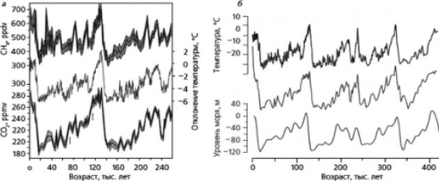
Ice cores are sources of very reliable paleoclimatic information. They can be used to trace the gas composition of the air enclosed in ice (including greenhouse gases) of the atmosphere of the past centuries and millennia. According to the isotopic composition of the base of ice - atmospheric precipitation, paleotemperatures are determined in laboratories - temperatures for the past period.
The deepest drilling with core sampling to date has been carried out in the area of the Russian Antarctic station Vostok. The ice in this area, due to its low movement, is ideal for obtaining long-term data. In the implementation of this project, the role of Vladimir Mikhailovich Kotlyakov, the leader of the Russian glaciological school, is great.
Deep drilling with coring began at the Vostok station in the 1960s and continued for more than 50 years. On February 5, 2012, drilling was completed at around 3769.3 meters, reaching the largest (out of 145 known) subglacial lakes in Antarctica - Lake Vostok.
The fact that the existence of such lakes is theoretically possible was suggested by Igor Alekseevich Zotikov in the early 1960s. Subsequent data from radar surveys made it possible already at the end of the 20th century to establish some parameters of Lake Vostok: a length of about 275 km, a width of about 75 km. Its area is approximately half the area of Baikal. The discovery of Lake Vostok is called the largest geographical discovery of the 21st century, which is of world significance.
The significance of this discovery lies not only in obtaining materials about the lake, which was covered with ice almost 500 thousand years ago and has not yet been in contact with the modern geospheres of the Earth, but also in information about the features of ice for the entire period of its formation.
Based on the results of deciphering the features of the air included in the ice, data on the gas composition of the Earth and the content of carbon dioxide and methane for 430 thousand years have been obtained to date. At the same time, according to isotopic and other data, it was established that climatic changes are of a rhythmic (cyclical) nature (Fig. 11).
Scientists have identified four warming-cooling climate cycles in Antarctica with a frequency of about 100,000 years. Of course, the average annual temperatures throughout the planet varied in a much narrower range than in Antarctica, but the patterns of climate fluctuations were the same.

Rice. eleven.
An analysis of temperature graphs and the content of various greenhouse gases in Antarctic ice cores made it possible to establish the closest relationship between temperature changes and CO 2 content. Moreover, changing the content carbon dioxide followed a change in temperature: the temperature rose, the content of carbon dioxide in it increased (and not vice versa).
Oleg Georgievich Sorokhgin and Sergey Alexandrovich Ushakov came to a similar conclusion when studying the ozone screen: “it can be concluded that the role of anthropogenic impact on the ozone layer in the Earth’s stratosphere, in which “ozone holes” occur, is negligible - approximately four orders of magnitude lower than the influence of natural factors. Therefore, all fluctuations in the ozone concentration in earth's atmosphere are exclusively natural in nature and have nothing to do with human activity.
This conclusion is also a discovery, which also has great practical value. If you agree with him, then the states can stop spending huge amounts of money aimlessly on the fight against "ozone holes".
But back to Lake Vostok, the study of which is just beginning. At this stage, scientists still have only a lot of questions: how did it form, is there life in it; if so, how is it preserved, what features do food chains have, etc. The answers to these questions will be provided by new theoretical discoveries.
Against the backdrop of the great geographical discoveries in Antarctica, numerous discoveries in the Arctic have been “lost” a little, although the Arctic region has long been studied in a variety of conditions, including by Russian research teams.
Only here, since 1937, unique drifting research stations "North Pole" have been organized on the ice floes. Each station after the destruction of the ice floe completes its work. Since this process is very active in the Arctic, drifting stations have been organized almost annually since 2003. To date, their number has exceeded 40. With their help, complex scientific observations are carried out at high latitudes over the state of the Arctic landscapes along the entire drift of the ice field of the station, and these distances usually exceed 2000 km. For example, the station "North Pole-35" covered 2502 km during the drift, the station "North Pole-36" - 2909 km, the station "North Pole-38" - about 3000 km.
Research at polar stations is currently being carried out by scientists from high-latitude marine expeditions of the Arctic and Antarctic Research Institute. This year, the Arkgika-2017 expedition began its work. One of its main tasks is to study the processes occurring in the Arctic during warming.
The composition of polar expeditions necessarily includes glaciologists, meteorologists, hydrologists, aerologists, hydrographers and hydrochemists, geographers and other specialists may be involved. Scientists monitor the movement and melting of Arctic ice, study the bottom topography and water properties, measure the ozone content and the concentration of greenhouse gases in the surface layers of the atmosphere.
The results of such studies and monitoring of the natural environment are the basis for improving the technology for monitoring the state of the Arctic Ocean, the development and information support of weather forecasting methods and climate models in the Arctic.
At present, the formation of new geographical objects often occurs as a result of economic activity. Such is the nature of forest parks, quarries, industrial dumps, cities, agricultural landscapes and other natural and anthropogenic landscapes with new properties. Many of these properties are deeply characterized in the series teaching aids, prepared at the Faculty of Geography of Moscow State University under the guidance of Vladimir Aleksandrovich Nikolaev.
The connecting thread of these manuals is the geo-ecological concept of the cultural landscape. In the series, I would especially like to highlight the manual “Natural-anthropogenic landscapes: industrial and transport geotechnical systems. Geoecological foundations of landscape construction” (2013). Its final section is devoted to the properties and principles of creating a cultural landscape as a noospheric geoecological system.
The creation of cultural landscapes is one of the most important conditions for the sustainable development of earthly civilization. The first cultivated agricultural landscape (Stone steppe) was created in Russia according to the project of V. V. Dokuchaev (Fig. 12).
Sometimes, as a result of economic activity, objects with very new (even for the whole Earth) properties can be formed. Such are, for example, waste heaps (dumps) of the Chelyabinsk coal deposit, in which scientists discovered 40 new minerals formed in an oxygen environment during long-term storage and storage of waste rock removed from mines.
New geographical discoveries are initiated by the development of the subject of study of geography: from the Ecumene to ancient world before environment currently. And if “geography is a science about the environment”, then can the conclusion expressed by the most famous geographers at the XI Congress of the Russian Geographical Society that “environmental improvement is a reality” be considered a geographical discovery?

Rice. 12.
Fundamental changes in the level of knowledge of the world as an environment are made by achievements in the field of studying one of the most fundamental concepts of modern geography, according to Anatoly Grigoryevich Isachenko - the ecological potential of landscapes (EPL).
EPL is a key concept in ecological and geographical research. A. G. Isachenko understands it as the whole set natural conditions that affect people's lives and create specific local habitats. At the initial assessment of the EPL, he recommends using the climate biological efficiency index (TC), proposed by N.I. Ivanov. The practical result of such an assessment is the map "Ecological potential of Russian landscapes" (Fig. 13) .
When compiling the map, the TC was determined for all landscapes identified on the “Landscape Map of the USSR” at a scale of 1: 4,000,000 (M.,
1988). Many important EPL indicators correlate well with TC values, including the annual duration of a comfortable temperature period, the intensity of the biological cycle of substances, the annual production of phytomass, etc.

Rice. 13.
- 1 - the highest; 2 - relatively high; 3 - medium; 4 - low;
- 5 - very low; 6 - extremely low; 7 - mountainous territories
The ecological potential inherent in natural landscapes is subjected to anthropogenic impact, as a result of which it state of the art more or less different from the original. Thus, an exhaustive characterization of the actual ecological state of landscapes requires a comprehensive account of anthropogenic "layers" on the natural background. The study of anthropogenic impacts on geosystems is part of the tasks of physical geography; ecological and geographical research is of direct interest to the environmental consequences of this impact.
Theoretical discoveries are the future of geographical science. Many of them will arise on the basis of a deeper study of geographic objects that were not characteristic of the former Earth: natural-anthropogenic complexes, geoecological systems, cultural landscapes, etc.
So, the process of knowing the Earth through geographical discoveries is eternal, and you, dear reader, can also take part in it. Moreover, for this it is not always necessary to receive a higher geographical education, it is enough just to study geography well at school and be attentive during trips, excursions, hiking trips (especially if they are of a research nature). It is useful to browse the sites of the Russian Geographical Society. Institute of Geography of the Russian Academy of Sciences, reserves and other specially protected natural areas, professional blogs of geographers.
But discoveries that are significant for science and society, of course, require deep geographical knowledge, which can only be obtained in various higher educational institutions. And there are plenty of such discoveries ahead! President of the International Geographical Union and Vice-President of the Russian Geographical Society, Professor Vladimir Alexandrovich Kolosov, in an interview with Komsomolskaya Pravda, claims that “there is still a lot of unknown on Earth, and therefore it’s not boring to be a geographer now” .
- A colored and more lethal version of this card can be found at .
The era of great geographical discoveries had a huge impact on the development of all mankind. The discovery of new lands, trade routes and more convenient sea routes made it possible to develop trade and social relations between countries and continents, develop many sciences, and expand people's understanding of the structure of the world.
Prerequisites for great geographical discoveries
Throughout history, many geographical discoveries have been made, but only those that were made at the end of the 15th - beginning of the 16th century entered into world history as the Greats. This is explained by the fact that neither before nor after this period, no one was able to repeat the success of medieval discoverers and make such large-scale discoveries.
At the turn of the 15th-16th centuries, brave sailors managed to discover previously unknown lands for the entire Western world - South Africa and America, find new ways to Japan, China, Indonesia, cross the Pacific Ocean, conquer the harsh polar waters.

Rice. 1. Sea travel.
Travelers of that time had not only the desire to make discoveries, but also all the means to achieve their goal:
- fast sailing ships;
- devices that helped to navigate in distant sea voyages;
- special navigational charts that facilitated laying courses on the high seas or ocean.
The main reason for the accomplishment of new geographical discoveries was the increased need for new goods, raw materials, more convenient and shorter trade routes.
Western merchants and industrialists saw the possibility of easy enrichment by robbing rich peoples from distant lands. Such magical land India seemed to many, a free and safe way to which ran only through the Atlantic Ocean.
TOP 5 articles
who read along with this
Rice. 2. Indian goods.
Goods from India have been very popular in Europe since ancient times. However, there were no direct trade routes with this exotic country: there were hostile states on the way to India, and trade was carried out through numerous intermediaries. Indian spices, fabrics, gold, jewelry, like a magnet, attracted European travelers.
Great geographical discoveries
The first on the way to the great geographical discoveries were the Portuguese. They were quickly joined by the Spaniards and the British, who also made desperate attempts in search of new rich lands.
However, the great geographical discoveries were made not only by European navigators. There were many brave pioneers in Russia who opened up the vast expanses of Siberia and the Far East to the world.
Table "Great geographical discoveries"
|
opening date |
Traveler |
Perfect discoveries |
|
Bartolomeu Dias |
Opening of the sea route Indian Ocean along the African coast |
|
|
Christopher Columbus |
Discovery of a new continent - America |
|
|
John Cabot |
The beginning of the search for a northern route to India. Discovery of the Strait of Labrador |
|
|
Vasco da Gama |
Opening of the sea route to India |
|
|
Pedro Carbal |
Discovery of Brazil |
|
|
Vasca Nuñens Balboa |
Crossing the Isthmus of Panama and opening the Pacific Ocean |
|
|
Ferdinand Magellan |
First in the world trip around the world, during which it was proved that the Earth has the shape of a sphere |
|
|
Abel Tasman |
Discovery of Australia and New Zealand |
|
|
Semyon Dezhnev and Fedot Popov |
Opening of the strait between Asia and North America |
Consequences of the great geographical discoveries
New, previously unexplored lands inhabited by completely unfamiliar peoples, seas and boundless oceans amazed the imagination and opened up great opportunities that could not even be dreamed of before.

Rice. 3. Discovery of America.
The most important consequences of the great discoveries include:
- Development of relations and strengthening of ties between different states.
- Development of trade and industry.
- The beginning of the era of colonialism.
- Artificial interruption of Indian civilizations in the New World.
- A leap in the development of the natural sciences.
- Establishment of modern contours of the continents.
What have we learned?
When studying the topic “Table “Great geographical discoveries” in the 7th grade history program, we learned what period the great geographical discoveries belong to and why they went down in history under that name. We found out which travelers made the most significant discoveries, and what role they played in the history of mankind.
Topic quiz
Report Evaluation
Average rating: 4.5. Total ratings received: 900.
It seems that the days of the pioneers have already passed, there are no white spots left on the map. But it turns out that today you can travel, explore the unknown corners of the planet. Let all the continents and islands have already been discovered, let the most remote and hard-to-reach areas be seen from space, and the inquisitive human mind sets new tasks for itself and solves them, organizes expeditions. Who are they, modern travelers of the 21st century?
Names of modern travelers
When we remember the famous pioneers, along with the great Columbus, Magellan, Cook, Bellingshausen, Lazarev and others, we are also talking about our contemporaries. The names of Cousteau, Heyerdahl, Senkevich, Konyukhov and other researchers also sound like a hymn to the study of our planet. Modern travelers and their discoveries are a wonderful
Jacques Yves Cousteau
Cousteau - the greatest oceanographer, French scientist and researcher. This is a man who discovered the underwater world for mankind. It was with his hands that goggles for the first scuba gear were made, and the first scientific vessel was equipped to study the depths of the sea. He owns the first films shot underwater.

For the first time, a person got the opportunity to move freely in the water column and descend to depths of up to 90 m. Under the leadership of Cousteau, the first underwater expeditions were organized. At first it was archaeological research at the bottom of the ocean and photography at depths of several kilometers.
When Cousteau created the "underwater saucer" - a mini-submarine, the possibilities for studying the water column increased dramatically. The continuation was the foundation of temporary underwater scientific stations, where modern travelers lived for several months and could make observations directly at sea.
The result of Cousteau's many years of work on the study of the underwater world were books and films that were very popular: "In the World of Silence", "World without Sun", "Cousteau's Underwater Odyssey". From 1957 he headed the Oceanographic Museum in Monaco. In 1973, the Cousteau Society for the Protection of Marine Nature was founded.
Among his honorary awards, he considered the Order of the Legion of Honor to be the main one. Cousteau died in 1997 in Paris.
Thor Heyerdahl
This name is also familiar to anyone who has even the slightest interest in travel. Thor Heyerdahl became famous for his sea voyages undertaken to prove his point of view on the settlement of different parts of the world.
Heyerdahl was the first to put forward the idea that the islands of Polynesia could be inhabited by immigrants from South America. To prove this theory, modern travelers under his leadership made an unparalleled voyage on the Kon-Tiki balsa raft across the Pacific Ocean. Having overcome about 8 thousand km in 101 days, the expedition reached the Tuamotu Islands. At the same time, the raft retained its buoyancy, and if it were not for the storm, it could certainly have reached the shores of Asia.
This was followed by expeditions on reed boats "Ra" and "Ra-2", in which our compatriot Yuri Senkevich took part. The boat "Tigris", sailing on which was supposed to show the possibility of connections between Mesopotamia and the Hindustan Peninsula, was burned by the crew in protest against military operations off the coast of Djibouti, and the expedition was not completed.

Heyerdahl disagreed on many points. academia and put forward his theories. For many years he studied the mysteries of Easter Island, especially the origin of the famous stone idols. Tur argued that these giant statues could have been made and delivered to the site by the natives of the island, who did not have modern stone-working tools and vehicles. And the results of his research were sensational, although not recognized by most scientists.
Of the controversial theories of Heyerdahl, we also note the version of the connections between the Vikings and the inhabitants of the Caucasus and Azov. He believed that the Vikings came from North Caucasus. But his death in 2002 prevented him from proving this theory.
Numerous books by Heyerdahl about his views on world exploration and travel, documentaries, shot about them, still remain very exciting and interesting for any person.
Yuri Senkevich
A modern Russian traveler and host of the most popular TV program in our country "Travel Club", a polar explorer, he participated in the 12th Soviet Antarctic expedition.
In 1969, when organizing an expedition to Ra, Thor Heyerdahl wrote a letter to the USSR Academy of Sciences inviting a doctor with good knowledge of in English, with experience in expeditions and a sense of humor. The choice fell on Senkevich. Cheerful and cheerful, with an optimistic outlook on life and the skills of a practicing doctor, Yuri quickly became friends with Heyerdahl and other team members.

Subsequently, they more than once participated in the expeditions of the famous Norwegian. Many of Heyerdahl's studies became known to the Soviet viewer immediately thanks to the TV show hosted by Yuri Senkevich. "Cinema Travel Club" became for many a window to the world, allowing them to get acquainted with interesting places on the globe. The guests of the program were modern travelers: Heyerdahl, Cousteau, Jacek Palkiewicz, Carlo Mauri and many others.
Senkevich took part in the medical support of expeditions to the North Pole and Everest. Yuri Alexandrovich died in 2006 on the set of another TV show.
Tim Severin
Many modern travelers follow the routes of seafarers and pioneers of the past. One of the most famous is Briton Tim Severin.
He made his first journey in the footsteps of Marco Polo on motorcycles. Leaving Venice, Severin and his comrades crossed almost all of Asia and reached the borders of China. Here the journey had to be completed, as permission to visit the country was not received. Further study followed (while sailing along it in a canoe and motor boat). The next expedition is on the route of St. Brendan across the Atlantic Ocean.
Inspired by the adventures of Sinbad the Sailor, Severin made the transition from Oman to China on a sailing ship, guided only by the stars.

In 1984, Severin, with a team of 20 rowers, repeated the route of the Argonauts to Colchis (Western Georgia). And the next year he traveled in the footsteps of Odysseus from the imperishable poem of the same name by Homer.
These are just some of Severin's routes. He wrote fascinating books about his adventures, and for "The Journey of Sinbad" he was awarded the prestigious Thomas Cook Prize.
Modern travelers of the 21st century
Despite the fact that the yard is the 21st century, the spirit of love for adventure and travel has not faded. And now there are people who cannot sit at home in comfort, they are attracted by the unknown, the unknown.
Among them there are also modern travelers of Russia. Perhaps the most famous of them is Fedor Konyukhov.
Fedor Konyukhov
"First" is often added to his name. He was the first Russian to visit the three poles of the Earth: North, South and Everest. He was the first on Earth to conquer five poles - the Pole of Inaccessibility in Antarctica and Cape Horn, considered such for yachtsmen, were added to the previous ones. He was the first Russian to overcome the "big seven" - he climbed the highest peaks of all continents, considering Europe and Asia separately.

He has many expeditions, mostly extreme ones. Konyukhov traveled four times on a yacht around the world. Member of the ski crossing "USSR - North Pole - Canada".
His books are read in one breath. And in the plans for the future - in a balloon.
Dmitry Shparo
Let's make a reservation right away: this is a polar traveler and explorer. Back in 1970, he led a ski expedition to the islands of Komsomolskaya Pravda. Three years later he traveled to Taimyr in search of the warehouse of the famous polar explorer Eduard Toll. In 1979, under his leadership, the world's first skiing expedition to the North Pole was made.
One of the most famous campaigns - to Canada through the Arctic Ocean as part of a joint Soviet-Canadian expedition.
In 1998, together with his son, he crossed on skis. In 2008, he organized two expeditions to the North Pole. One of them is famous for the world's first reaching the Pole on skis at night. And the second was attended by young people aged 16-18 years.

Dmitry Shparo - organizer of the Adventure Club. The institution holds marathons across the country with the participation of people confined to wheelchairs. The most famous was the international ascent to Kazbek of wheelchair users from Transcaucasia, Norway and Russia.
Modern Travelers
The geography of modern travel is very extensive. Basically, these are little-studied and hard-to-reach areas of the Earth. These hikes most often take place in extreme conditions, requiring the exertion of all forces.
Of course, it is difficult to cover all the names in one article. Anatoly Khizhnyak, exploring little-studied tribes in the jungles of the Amazon and Papua New Guinea... Naomi Uemura, who single-handedly made a trip to the North Pole, sailed through the Amazon, conquered Mont Blanc, Matterhorn, Kilimanjaro, Akonkugua, Everest... the first person to climb to all 14 eight-thousanders of the world... One could write a separate book about each of them. Their adventures inspire travelers.
- In contact with 0
- Google+ 0
- OK 0
- Facebook 0