Earth's lithospheric plates are huge blocks. Their foundation is formed by highly folded granite metamorphosed igneous rocks. Titles lithospheric plates will be listed in the article below. From above they are covered with a three-four-kilometer "cover". It is formed from sedimentary rocks. The platform has a relief consisting of individual mountain ranges and vast plains. Next, the theory of the movement of lithospheric plates will be considered.
The emergence of the hypothesis
The theory of the movement of lithospheric plates appeared at the beginning of the twentieth century. Subsequently, she was destined to play a major role in the exploration of the planet. The scientist Taylor, and after him Wegener, put forward the hypothesis that over time there is a drift of lithospheric plates in a horizontal direction. However, in the thirties of the 20th century, a different opinion was established. According to him, the movement of lithospheric plates was carried out vertically. This phenomenon was based on the process of differentiation of the planet's mantle matter. It became known as fixism. Such a name was due to the fact that the permanently fixed position of sections of the crust relative to the mantle was recognized. But in 1960, after the discovery of a global system of mid-ocean ridges that encircle the entire planet and come out on land in some areas, there was a return to the hypothesis of the early 20th century. However, the theory has taken on a new form. Block tectonics has become the leading hypothesis in the sciences that study the structure of the planet.
Basic provisions
It was determined that there are large lithospheric plates. Their number is limited. There are also smaller lithospheric plates of the Earth. The boundaries between them are drawn according to the concentration in the sources of earthquakes.
The names of the lithospheric plates correspond to the continental and oceanic regions located above them. There are only seven blocks with a huge area. The largest lithospheric plates are the South and North American, Euro-Asian, African, Antarctic, Pacific and Indo-Australian.
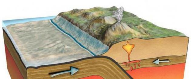
Blocks floating in the asthenosphere are characterized by solidity and rigidity. The above areas are the main lithospheric plates. In accordance with the initial ideas, it was believed that the continents make their way through the ocean floor. At the same time, the movement of lithospheric plates was carried out under the influence of an invisible force. As a result of the research, it was revealed that the blocks float passively over the material of the mantle. It is worth noting that their direction is vertical at first. The mantle material rises under the crest of the ridge. Then there is a spread in both directions. Accordingly, there is a divergence of lithospheric plates. This model represents the ocean floor as a giant. It comes to the surface in the rift areas of the mid-ocean ridges. Then hides in deep-sea trenches.
The divergence of lithospheric plates provokes the expansion of oceanic beds. However, the volume of the planet, despite this, remains constant. The fact is that the birth of a new crust is compensated by its absorption in subduction (underthrust) areas in deep-sea trenches.

Why does lithospheric plates move?
The reason is the thermal convection of the planet's mantle material. The lithosphere is stretched and uplifted, which occurs over ascending branches from convective currents. This provokes the movement of lithospheric plates to the sides. As the platform moves away from the mid-ocean rifts, the platform becomes compacted. It becomes heavier, its surface sinks down. This explains the increase in ocean depth. As a result, the platform plunges into deep-sea trenches. When attenuating from the heated mantle, it cools and sinks with the formation of basins, which are filled with sediments.
Plate collision zones are areas where the crust and platform experience compression. In this regard, the power of the first increases. As a result, the upward movement of lithospheric plates begins. It leads to the formation of mountains.
Research
The study today is carried out using geodetic methods. They allow us to conclude that the processes are continuous and ubiquitous. Collision zones of lithospheric plates are also revealed. The lifting speed can be up to tens of millimeters.
Horizontally large lithospheric plates float somewhat faster. In this case, the speed can be up to ten centimeters during the year. So, for example, St. Petersburg has already risen by a meter over the entire period of its existence. Scandinavian peninsula - by 250 m in 25,000 years. The mantle material moves relatively slowly. However, earthquakes and other phenomena occur as a result. This allows us to draw a conclusion about the high power of moving the material.
Using the tectonic position of the plates, researchers explain many geological phenomena. At the same time, during the study, it turned out that the complexity of the processes occurring with the platform is much greater than it seemed at the very beginning of the appearance of the hypothesis.
Plate tectonics could not explain changes in the intensity of deformations and movement, the presence of a global stable network of deep faults, and some other phenomena. It also remains open question about historical beginning actions. Direct signs indicating plate-tectonic processes have been known since the late Proterozoic. However, a number of researchers recognize their manifestation from the Archean or early Proterozoic.

Expanding Research Opportunities
The advent of seismic tomography led to the transition of this science to a qualitatively new level. In the mid-eighties of the last century, deep geodynamics became the most promising and young direction of all the existing geosciences. However, the solution of new problems was carried out using not only seismic tomography. Other sciences also came to the rescue. These include, in particular, experimental mineralogy.
Thanks to the availability of new equipment, it became possible to study the behavior of substances at temperatures and pressures corresponding to the maximum at the depths of the mantle. The methods of isotope geochemistry were also used in the studies. This science studies, in particular, the isotopic balance of rare elements, as well as noble gases in various earthly shells. In this case, the indicators are compared with meteorite data. Methods of geomagnetism are used, with the help of which scientists are trying to uncover the causes and mechanism of reversals in a magnetic field.
Modern painting
The platform tectonics hypothesis continues to satisfactorily explain the process of crustal development during at least the last three billion years. At the same time, there are satellite measurements, according to which the fact that the main lithospheric plates of the Earth do not stand still is confirmed. As a result, a certain picture emerges.
There are three most active layers in the cross section of the planet. The thickness of each of them is several hundred kilometers. It is assumed that the main role in global geodynamics is assigned to them. In 1972, Morgan substantiated the hypothesis put forward in 1963 by Wilson about ascending mantle jets. This theory explained the phenomenon of intraplate magnetism. The resulting plume tectonics has become increasingly popular over time.

Geodynamics
With its help, the interaction of rather complex processes that occur in the mantle and the crust is considered. In accordance with the concept set forth by Artyushkov in his work "Geodynamics", the gravitational differentiation of matter acts as the main source of energy. This process is noted in the lower mantle.
After the heavy components (iron, etc.) are separated from the rock, a lighter mass of solids remains. She descends into the core. The location of the lighter layer under the heavy one is unstable. In this regard, the accumulating material is collected periodically into fairly large blocks that float into the upper layers. The size of such formations is about a hundred kilometers. This material was the basis for the formation of the upper
The lower layer is probably an undifferentiated primary substance. During the evolution of the planet, due to the lower mantle, the upper mantle grows and the core increases. It is more likely that blocks of light material are uplifted in the lower mantle along the channels. In them, the temperature of the mass is quite high. At the same time, the viscosity is significantly reduced. The increase in temperature is facilitated by the release of a large amount of potential energy in the process of lifting matter into the region of gravity at a distance of about 2000 km. In the course of movement along such a channel, a strong heating of light masses occurs. In this regard, the substance enters the mantle, having a sufficiently high temperature and significantly less weight in comparison with the surrounding elements.
Due to the reduced density, light material floats into the upper layers to a depth of 100-200 kilometers or less. With decreasing pressure, the melting point of the components of the substance decreases. After the primary differentiation at the "core-mantle" level, the secondary one occurs. At shallow depths, light matter is partially subjected to melting. During differentiation, denser substances are released. They sink into the lower layers of the upper mantle. The released lighter components rise accordingly.
The complex of motions of substances in the mantle, associated with the redistribution of masses with different densities as a result of differentiation, is called chemical convection. The rise of light masses occurs at intervals of about 200 million years. At the same time, intrusion into the upper mantle is not observed everywhere. In the lower layer, the channels are located at a sufficiently large distance from each other (up to several thousand kilometers).

Boulder lifting
As mentioned above, in those zones where large masses of light heated material are introduced into the asthenosphere, its partial melting and differentiation occur. In the latter case, the separation of components and their subsequent ascent are noted. They quickly pass through the asthenosphere. When they reach the lithosphere, their speed decreases. In some areas, matter forms accumulations of anomalous mantle. They lie, as a rule, in the upper layers of the planet.
anomalous mantle
Its composition approximately corresponds to normal mantle matter. The difference between the anomalous accumulation is a higher temperature (up to 1300-1500 degrees) and a reduced speed of elastic longitudinal waves.
The influx of matter under the lithosphere provokes isostatic uplift. Due to the elevated temperature, the anomalous cluster has a lower density than the normal mantle. In addition, there is a small viscosity of the composition.
In the process of entering the lithosphere, the anomalous mantle is rather quickly distributed along the sole. At the same time, it displaces the denser and less heated matter of the asthenosphere. In the course of movement, the anomalous accumulation fills those areas where the sole of the platform is in an elevated state (traps), and it flows around deeply submerged areas. As a result, in the first case, an isostatic uplift is noted. Above submerged areas, the crust remains stable.
Traps
The process of cooling the upper mantle layer and the crust to a depth of about a hundred kilometers is slow. In general, it takes several hundred million years. In this regard, inhomogeneities in the thickness of the lithosphere, explained by horizontal temperature differences, have a rather large inertia. In the event that the trap is located not far from the upward flow of the anomalous accumulation from the depth, a large amount of the substance is captured very heated. As a result, a rather large mountain element is formed. In accordance with this scheme, high uplifts occur in the area of epiplatform orogeny in
Description of processes
In the trap, the anomalous layer undergoes compression by 1–2 kilometers during cooling. The bark located on top is immersed. Precipitation begins to accumulate in the formed trough. Their heaviness contributes to even greater subsidence of the lithosphere. As a result, the depth of the basin can be from 5 to 8 km. At the same time, during the compaction of the mantle in the lower part of the basalt layer, a phase transformation of the rock into eclogite and garnet granulite can be observed in the crust. Due to the heat flow leaving the anomalous substance, the overlying mantle is heated and its viscosity decreases. In this regard, a gradual displacement of the normal cluster is observed.

Horizontal offsets
With the formation of uplifts in the process of the anomalous mantle reaching the crust on the continents and oceans, there is an increase in the potential energy stored in the upper layers of the planet. To dump excess substances, they tend to disperse to the sides. As a result, additional stresses are formed. Associated with them different types plate and crust movements.
The expansion of the ocean floor and the floating of the continents are the result of the simultaneous expansion of the ridges and the sinking of the platform into the mantle. Under the first are large masses of highly heated anomalous matter. In the axial part of these ridges, the latter is directly under the crust. The lithosphere here has a much smaller thickness. At the same time, the anomalous mantle spreads in the area of high pressure - in both directions from under the ridge. At the same time, it quite easily breaks the ocean's crust. The crevice is filled with basaltic magma. It, in turn, is melted out of the anomalous mantle. In the process of solidification of magma, a new one is formed. This is how the bottom grows.

Process Features
Beneath the mid-ridges, the anomalous mantle has reduced viscosity due to elevated temperatures. The substance is able to spread quite quickly. As a result, the growth of the bottom occurs at an increased rate. The oceanic asthenosphere also has a relatively low viscosity.
The main lithospheric plates of the Earth float from the ridges to the places of immersion. If these areas are in the same ocean, then the process occurs at a relatively high speed. This situation is typical today for the Pacific Ocean. If the expansion of the bottom and the subsidence occurs in different areas, then the continent located between them drifts in the direction where the deepening occurs. Under the continents, the viscosity of the asthenosphere is higher than under the oceans. Due to the resulting friction, there is a significant resistance to movement. As a result, the rate at which the bottom expands is reduced if there is no compensation for the mantle subsidence in the same area. Thus, growth in pacific ocean going faster than in the Atlantic.
In the distant 2000s, there was a program on one Belarusian channel where children were simply told about difficult things. I watched it every day at 3 pm, right after the 7th lesson. It was thanks to her that I learned what lithospheric plates are. In this answer, I want to delve a little deeper into this topic so that it seems even more interesting.
What are called lithospheric plates
When you are a small child, you live without thinking about anything. It would never have occurred to me that the top layer of the Earth is broken into several pieces, which are called plates. For the first time, an American archaeologist guessed about their existence, and a few years later their existence was fully proven, and a European scientist already determined their boundaries.
There are 13 large lithospheric plates on our planet (they cover more than 85% of the Earth). Some mistakenly believe that these are generally all existing plates. However, it is not. There are more than 50 microplates and medium-sized plates in the world. Sometimes plates disappear due to the influence of various factors. Plates that no longer exist:
- Cimmerian plate;
- Congo plate;
- Bellingshausen plate;
- Kula plate;
- Phoenix plate.
Usually lithospheric plates disappear due to collision with each other. When two plates of approximately the same size collide, mountains form.

Amasia supercontinent
Everyone has heard about the ancient huge continent, which scientists have dubbed "Pangaea". It existed 300 million years ago, but split into several continents due to the movement of lithospheric plates.
The plates continue to move to this day. Most likely, in a few hundred million years, a new huge continent will appear on Earth. It has already been called Amazia. According to this theory, northern and South America reconnect, and then head north together and collide with Eurasia.

There are also two less popular theories. One of them says that a new supercontinent will appear in the same place where the Pangea was located. And the other claims that Amasia will appear on the other side of the globe (in the Pacific Ocean).
lithospheric plate- A large rigid block of the Earth's lithosphere, limited by seismically and tectonically active fault zones, according to plate tectonics, such blocks move along the asthenosphere. → Fig. 251, p. 551 Syn.: tectonic plate … Geography Dictionary
A large (several thousand km across) block of the earth's crust, including not only the continental, but also the oceanic crust associated with it; bounded on all sides by seismically and tectonically active fault zones... Big Encyclopedic Dictionary
A large (several thousand kilometers across) block of the earth's crust, including not only the continental, but also the oceanic crust associated with it; bounded on all sides by seismically and tectonically active fault zones. * * * LITHOSPHERIC… … encyclopedic Dictionary
A large (several thousand km across) block of the earth's crust, which includes not only the continental, but also the adjacent Oksanich. bark; bounded on all sides by seismically and tectonically active fault zones... Natural science. encyclopedic Dictionary
The lithospheric plate Juan de Fuca (named after the navigator Juan de Fuca, a Greek by nationality who served Spain) is tectonic ... Wikipedia
A three-dimensional model showing the position of the remnants of the Farallon Plate in the depths of the Earth's mantle ... Wikipedia
- ... Wikipedia
- (Spanish Nazca) a lithospheric plate located in the eastern Pacific Ocean. The plate got its name from the name of the area of the same name in Peru. The earth's crust is oceanic. On the eastern border of the Nazca plate formed ... Wikipedia
Plate tectonics (plate tectonics) is a modern geodynamic concept based on the position of large-scale horizontal displacements of relatively integral fragments of the lithosphere (lithospheric plates). Thus, plate tectonics considers the movements and interactions of lithospheric plates.
Alfred Wegener first suggested horizontal movement of crustal blocks in the 1920s as part of the “continental drift” hypothesis, but this hypothesis did not receive support at that time. Only in the 1960s, studies of the ocean floor provided indisputable evidence of the horizontal movement of plates and the processes of expansion of the oceans due to the formation (spreading) of the oceanic crust. The revival of ideas about the predominant role of horizontal movements occurred within the framework of the "mobilistic" direction, the development of which led to the development modern theory plate tectonics. The main provisions of plate tectonics were formulated in 1967-68 by a group of American geophysicists - W. J. Morgan, C. Le Pichon, J. Oliver, J. Isaacs, L. Sykes in the development of earlier (1961-62) ideas of American scientists G. Hess and R. Digts on the expansion (spreading) of the ocean floor
Fundamentals of plate tectonics
The fundamentals of plate tectonics can be traced back to a few fundamental
1. The upper stone part of the planet is divided into two shells, which differ significantly in rheological properties: a rigid and brittle lithosphere and an underlying plastic and mobile asthenosphere.
2. The lithosphere is divided into plates, constantly moving along the surface of the plastic asthenosphere. The lithosphere is divided into 8 large plates, dozens of medium plates and many small ones. Between the large and medium slabs there are belts composed of a mosaic of small crustal slabs.
Plate boundaries are areas of seismic, tectonic, and magmatic activity; the inner areas of the plates are weakly seismic and are characterized by a weak manifestation of endogenous processes.
More than 90% of the Earth's surface falls on 8 large lithospheric plates:
australian plate,
Antarctic Plate,
african plate,
Eurasian Plate,
Hindustan Plate,
Pacific Plate,
North American Plate,
South American plate.
Middle plates: Arabian (subcontinent), Caribbean, Philippine, Nazca and Cocos and Juan de Fuca, etc.
Some lithospheric plates are composed exclusively of oceanic crust (for example, the Pacific Plate), others include fragments of both oceanic and continental crust.
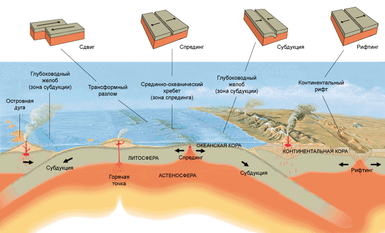
3. There are three types of relative plate movements: divergence (divergence), convergence (convergence) and shear movements.
Accordingly, three types of main plate boundaries are distinguished.
Divergent boundaries are the boundaries along which the plates move apart.
The processes of horizontal stretching of the lithosphere are called rifting. These boundaries are confined to continental rifts and mid-ocean ridges in ocean basins.
The term "rift" (from the English rift - gap, crack, gap) is applied to large linear structures of deep origin, formed during the stretching of the earth's crust. In terms of structure, they are graben-like structures.
Rifts can be laid both on the continental and oceanic crust, forming a single global system oriented relative to the geoid axis. In this case, the evolution of continental rifts can lead to a break in the continuity of the continental crust and the transformation of this rift into an oceanic rift (if the expansion of the rift stops before the stage of break of the continental crust, it is filled with sediments, turning into an aulacogen).

The process of plate expansion in the zones of oceanic rifts (mid-ocean ridges) is accompanied by the formation of a new oceanic crust due to magmatic basalt melts coming from the asthenosphere. This process of formation of a new oceanic crust due to the influx of mantle matter is called spreading(from English spread - spread, deploy).
The structure of the mid-ocean ridge

In the course of spreading, each stretching pulse is accompanied by the inflow of a new portion of mantle melts, which, while solidifying, build up the edges of the plates diverging from the MOR axis.
It is in these zones that the formation of young oceanic crust occurs.
convergent borders are the boundaries along which plates collide. There can be three main variants of interaction in a collision: "oceanic - oceanic", "oceanic - continental" and "continental - continental" lithosphere. Depending on the nature of the colliding plates, several different processes can take place.
Subduction- the process of subducting an oceanic plate under a continental or other oceanic one. The subduction zones are confined to the axial parts of deep-sea trenches conjugated with island arcs (which are elements of active margins). Subduction boundaries account for about 80% of the length of all convergent boundaries.
When continental and oceanic plates collide, a natural phenomenon is the subduction of the oceanic (heavier) plate under the edge of the continental one; when two oceanic ones collide, the older one (that is, the cooler and denser) of them sinks.
The subduction zones have a characteristic structure: their typical elements are a deep-water trough - a volcanic island arc - a back-arc basin. A deep-water trench is formed in the zone of bending and underthrusting of the subducting plate. As this plate sinks, it begins to lose water (which is found in abundance in sediments and minerals), the latter, as is known, significantly reduces the melting temperature of rocks, which leads to the formation of melting centers that feed island arc volcanoes. In the rear of the volcanic arc, some extension usually occurs, which determines the formation of a back-arc basin. In the zone of the back-arc basin, the extension can be so significant that it leads to the rupture of the plate crust and the opening of the basin with oceanic crust (the so-called back-arc spreading process).

The subduction of the subducting plate into the mantle is traced by earthquake foci that occur at the contact of the plates and inside the subducting plate (which is colder and therefore more fragile than the surrounding mantle rocks). This seismic focal zone is called Benioff-Zavaritsky zone.
In subduction zones, the process of formation of a new continental crust begins.
A much rarer process of interaction between continental and oceanic plates is the process obduction– thrusting of a part of the oceanic lithosphere onto the edge of the continental plate. It should be emphasized that in the course of this process, the oceanic plate is stratified, and only it is advancing. top part– the crust and several kilometers of the upper mantle.
In the collision of continental plates, the crust of which is lighter than the substance of the mantle, and therefore is not able to sink into it, the process collisions. During the collision, the edges of the colliding continental plates are crushed, crushed, and systems of large thrusts are formed, which leads to the growth of mountain structures with a complex fold-thrust structure. A classic example of such a process is the collision of the Hindustan plate with the Eurasian one, accompanied by the growth of the grandiose mountain systems of the Himalayas and Tibet.
Collision process model

The collision process replaces the subduction process, completing the closure of the ocean basin. At the same time, at the beginning of the collision process, when the edges of the continents have already approached, the collision is combined with the subduction process (the remains of the oceanic crust continue to sink under the edge of the continent).
Collision processes are characterized by large-scale regional metamorphism and intrusive granitoid magmatism. These processes lead to the creation of a new continental crust (with its typical granite-gneiss layer).
Transform borders are the boundaries along which shear displacements of plates occur.
The boundaries of the lithospheric plates of the Earth

1 – divergent boundaries ( but - mid-ocean ridges, b - continental rifts); 2 – transform boundaries; 3 – convergent boundaries ( but - island arc, b - active continental margins in - conflict); 4 – direction and speed (cm/yr) of plate movement.
4. The volume of oceanic crust absorbed in the subduction zones is equal to the volume of the crust formed in the spreading zones. This provision emphasizes the opinion about the constancy of the volume of the Earth. But such an opinion is not the only and definitively proven. It is possible that the volume of the plans changes pulsatingly, or there is a decrease in its decrease due to cooling.
5. The main cause of plate movement is mantle convection. , caused by mantle thermogravitational currents.
The source of energy for these currents is the temperature difference between the central regions of the Earth and the temperature of its near-surface parts. At the same time, the main part of the endogenous heat is released at the boundary of the core and mantle during the process of deep differentiation, which determines the decay of the primary chondrite substance, during which the metal part rushes to the center, increasing the core of the planet, and the silicate part is concentrated in the mantle, where it further undergoes differentiation.
heated in central zones The rock lands expand, their density decreases, and they float, giving way to sinking colder and therefore heavier masses, which have already given up part of the heat in near-surface zones. This process of heat transfer goes on continuously, resulting in the formation of ordered closed convective cells. At the same time, in the upper part of the cell, the flow of matter occurs in an almost horizontal plane, and it is this part of the flow that determines the horizontal movement of the matter of the asthenosphere and the plates located on it. In general, the ascending branches of convective cells are located under the zones of divergent boundaries (MOR and continental rifts), while the descending branches are located under the zones of convergent boundaries.
Thus, the main reason for the movement of lithospheric plates is "drag" by convective currents.
In addition, a number of other factors act on the plates. In particular, the surface of the asthenosphere turns out to be somewhat elevated above the zones of ascending branches and more lowered in the zones of subsidence, which determines the gravitational "slip" of the lithospheric plate located on an inclined plastic surface. Additionally, there are processes of pulling the heavy cold oceanic lithosphere in the subduction zones into the hot, and as a result less dense, asthenosphere, as well as hydraulic wedging by basalts in the MOR zones.

Figure - Forces acting on lithospheric plates.
The main driving forces of plate tectonics are applied to the bottom of the intraplate parts of the lithosphere: the mantle drag forces FDO under the oceans and FDC under the continents, the magnitude of which depends primarily on the velocity of the asthenospheric current, and the latter is determined by the viscosity and thickness of the asthenospheric layer. Since under the continents the thickness of the asthenosphere is much less, and the viscosity is much greater than under the oceans, the magnitude of the force FDC almost an order of magnitude smaller than FDO. Under the continents, especially their ancient parts (continental shields), the asthenosphere almost wedges out, so the continents seem to be “sitting aground”. Since most of the lithospheric plates of the modern Earth include both oceanic and continental parts, it should be expected that the presence of a continent in the composition of the plate in the general case should “slow down” the movement of the entire plate. This is how it actually happens (the fastest moving are the almost purely oceanic plates Pacific, Cocos and Nasca; the slowest are the Eurasian, North American, South American, Antarctic and African, a significant part of whose area is occupied by continents). Finally, at convergent plate boundaries, where the heavy and cold edges of lithospheric plates (slabs) sink into the mantle, their negative buoyancy creates a force FNB(index in the designation of strength - from English negative feedback). The action of the latter leads to the fact that the subducting part of the plate sinks in the asthenosphere and pulls the entire plate along with it, thereby increasing the speed of its movement. Obviously the strength FNB operates episodically and only in certain geodynamic settings, for example, in cases of the collapse of slabs described above through a section of 670 km.
Thus, the mechanisms that set the lithospheric plates in motion can be conditionally assigned to the following two groups: 1) associated with the forces of mantle “dragging” ( mantle drag mechanism) applied to any points of the soles of the plates, in Fig. 2.5.5 - forces FDO And FDC; 2) related to the forces applied to the edges of the plates ( edge force mechanism), in the figure - forces FRP And FNB. The role of this or that driving mechanism, as well as these or those forces, is evaluated individually for each lithospheric plate.
The totality of these processes reflects the general geodynamic process, covering areas from the surface to deep zones of the Earth.


Mantle convection and geodynamic processes
At present, a two-cell closed-cell mantle convection is developing in the Earth's mantle (according to the through-mantle convection model) or separate convection in the upper and lower mantle with the accumulation of slabs under subduction zones (according to the two-tier model). The probable poles of the rise of the mantle matter are located in northeast Africa (approximately under the junction zone of the African, Somali and Arabian plates) and in the area of Easter Island (under the middle ridge of the Pacific Ocean - the East Pacific Rise).
The mantle subsidence equator follows an approximately continuous chain of convergent plate boundaries along the periphery of the Pacific and eastern Indian Oceans.
The current regime of mantle convection, which began about 200 million years ago with the collapse of Pangea and gave rise to modern oceans, will be replaced in the future by a single-cell regime (according to the model of through-mantle convection) or (according to an alternative model) convection will become through-mantle due to the collapse of slabs through a section of 670 km. This may lead to the collision of the continents and the formation of a new supercontinent, the fifth in the history of the Earth.
6. Movements of plates obey the laws of spherical geometry and can be described on the basis of Euler's theorem. Euler's rotation theorem states that any rotation of three-dimensional space has an axis. Thus, rotation can be described by three parameters: the coordinates of the rotation axis (for example, its latitude and longitude) and the angle of rotation. Based on this position, the position of the continents in past geological epochs can be reconstructed. An analysis of the movements of the continents led to the conclusion that every 400-600 million years they unite into a single supercontinent, which is further disintegrated. As a result of the split of such a supercontinent Pangea, which occurred 200-150 million years ago, modern continents were formed.
Some evidence of the reality of the mechanism of lithospheric plate tectonics
Older age of oceanic crust with distance from spreading axes(see picture). In the same direction, there is an increase in the thickness and stratigraphic completeness of the sedimentary layer.

Figure - Map of the age of the rocks of the ocean floor of the North Atlantic (according to W. Pitman and M. Talvani, 1972). Parts of the ocean floor of different age intervals are highlighted in different colors; The numbers indicate the age in millions of years.
geophysical data.

Figure - Tomographic profile through the Hellenic Trench, the island of Crete and the Aegean Sea. Gray circles are earthquake hypocenters. The plate of the submerging cold mantle is shown in blue, the hot mantle is shown in red (according to W. Spackman, 1989)

Remains of the huge Faralon Plate, which disappeared in the subduction zone under North and South America, fixed in the form of “cold” mantle slabs (section across North America, along S-waves). After Grand, Van der Hilst, Widiyantoro, 1997, GSA Today, v. 7, no. 4, 1-7
Linear magnetic anomalies in the oceans were discovered in the 1950s during geophysical studies of the Pacific Ocean. This discovery allowed Hess and Dietz to formulate the theory of ocean floor spreading in 1968, which grew into the theory of plate tectonics. They became one of the strongest proofs of the correctness of the theory.

Figure - Formation of strip magnetic anomalies during spreading.
The reason for the origin of strip magnetic anomalies is the process of the birth of the oceanic crust in the spreading zones of the mid-ocean ridges, the outflowing basalts, when cooling below the Curie point in the Earth's magnetic field, acquire residual magnetization. The direction of magnetization coincides with the direction magnetic field Earth, however, due to periodic reversals of the Earth's magnetic field, the erupted basalts form bands with different directions of magnetization: direct (coincides with the modern direction of the magnetic field) and reverse.

Figure - Scheme of the formation of the stripe structure of the magnetically active layer and magnetic anomalies of the ocean (Vine-Matthews model).
Consists of many layers piled on top of each other. However, we know best Earth's crust and the lithosphere. This is not surprising - after all, we not only live on them, but also draw from the depths most of the available to us natural resources. But even the upper shells of the Earth preserve millions of years of the history of our planet and the entire solar system.
These two concepts are so common in the press and literature that they have entered the everyday vocabulary. modern man. Both words are used to refer to the surface of the Earth or another planet - however, there is a difference between the concepts based on two fundamental approaches: chemical and mechanical.
Chemical aspect - the earth's crust
If we divide the Earth into layers, guided by differences in chemical composition, the top layer of the planet will be the earth's crust. This is a relatively thin shell, ending at a depth of 5 to 130 kilometers below sea level - the oceanic crust is thinner, and the continental, in mountainous areas, is the thickest. Although 75% of the mass of the crust falls only on silicon and oxygen (not pure, bound in the composition different substances), it is distinguished by the greatest chemical diversity among all layers of the Earth.
The richness of minerals also plays a role - various substances and mixtures created over billions of years of the planet's history. The Earth's crust contains not only "native" minerals that were created by geological processes, but also a massive organic legacy, such as oil and coal, as well as alien inclusions.
Physical aspect - lithosphere
Based on the physical characteristics of the Earth, such as hardness or elasticity, we get a slightly different picture - the inside of the planet will be wrapped in a lithosphere (from other Greek lithos, "rocky, hard" and "sphaira" sphere). It is much thicker than the earth's crust: the lithosphere extends up to 280 kilometers deep and even captures the upper solid part of the mantle!
The characteristics of this shell are fully consistent with the name - this is the only solid layer of the Earth, except for the inner core. Strength, however, is relative - the Earth's lithosphere is one of the most mobile in solar system, because of which the planet has changed its appearance more than once. But for significant compression, curvature and other elastic changes, thousands of years are required, if not more.

- An interesting fact is that a planet may not have a surface crust. Thus, the surface is its hardened mantle; The planet closest to the Sun lost its crust a long time ago as a result of numerous collisions.
To summarize, the earth's crust is the upper, chemically diverse part of the lithosphere, the solid shell of the earth. Initially, they had almost the same composition. But when only the underlying asthenosphere affected the depths and high temperatures, the hydrosphere, atmosphere, meteorite remnants and living organisms actively participated in the formation of minerals on the surface.
Lithospheric plates
Another feature that distinguishes the Earth from other planets is the variety of different types of landscapes on it. Of course, water also played an incredibly important role, which we will talk about a little later. But even the basic forms of the planetary landscape of our planet differ from the same Moon. The seas and mountains of our satellite are pits from meteorite bombardment. And on Earth, they were formed as a result of hundreds and thousands of millions of years of movement of lithospheric plates.
You've probably heard of plates by now - these are huge, stable fragments of the lithosphere that drift along the fluid asthenosphere, like broken ice on a river. However, there are two main differences between the lithosphere and ice:
- The gaps between the plates are small, and are quickly tightened due to the molten substance erupting from them, and the plates themselves are not destroyed by collisions.
- Unlike water, there is no constant flow in the mantle, which could set a constant direction for the movement of the continents.
So, driving force drift of lithospheric plates is the convection of the asthenosphere, the main part of the mantle - hotter flows from the earth's core rise to the surface, when cold ones sink back down. Considering that the continents differ in size, and the relief of their lower side mirrors the irregularities of the upper side, they also move unevenly and inconstantly.

Main plates
Over billions of years of movement of lithospheric plates, they repeatedly merged into supercontinents, after which they separated again. In the near future, in 200-300 million years, the formation of a supercontinent called Pangea Ultima is also expected. We recommend watching the video at the end of the article - it clearly shows how lithospheric plates have migrated over the past few hundred million years. In addition, the strength and activity of the movement of the continents determines the internal heating of the Earth - the higher it is, the more the planet expands, and the faster and freer the lithospheric plates move. However, since the beginning of the Earth's history, its temperature and radius have been gradually decreasing.
- An interesting fact is that plate drift and geological activity need not be fueled by the internal self-heating of the planet. For example, Jupiter's moon has many active volcanoes. But the energy for this is provided not by the core of the satellite, but by gravitational friction with , due to which the bowels of Io are heated.
The boundaries of the lithospheric plates are very arbitrary - some parts of the lithosphere sink under others, and some, like the Pacific plate, are generally hidden under water. Geologists today have 8 main plates that cover 90 percent of the entire area of the Earth:
- Australian
- Antarctic
- African
- Eurasian
- Hindustan
- Pacific
- North American
- South American

Such a division appeared recently - for example, the Eurasian plate 350 million years ago consisted of separate parts, during the merger of which Ural mountains, one of the most ancient on Earth. Scientists to this day continue to study the faults and the bottom of the oceans, discovering new plates and refining the boundaries of the old ones.
Geological activity
Lithospheric plates move very slowly - they crawl over each other at a speed of 1-6 cm / year, and move away as much as 10-18 cm / year. But it is the interaction between the continents that creates the geological activity of the Earth, tangible on the surface - volcanic eruptions, earthquakes and the formation of mountains always occur in the contact zones of the lithospheric plates.
However, there are exceptions - the so-called hot spots, which can exist in the depths of lithospheric plates. In them, molten flows of matter from the asthenosphere break upward, melting through the lithosphere, which leads to increased volcanic activity and regular earthquakes. Most often this happens near those places where one lithospheric plate creeps onto another - the lower, depressed part of the plate sinks into the Earth's mantle, thereby increasing the pressure of magma on the upper plate. However, now scientists are inclined to the version that the "drowned" parts of the lithosphere are melting, increasing pressure in the depths of the mantle and thereby creating updrafts. This can explain the anomalous remoteness of some hot spots from tectonic faults.

- An interesting fact is that shield volcanoes often form in hot spots, characteristic of their flat shape. They erupt many times, growing due to flowing lava. It is also a typical format for alien volcanoes. The most famous of them is on Mars, the highest point on the planet - its height reaches 27 kilometers!
Oceanic and continental crust of the Earth
The interaction of plates also leads to the formation of two different types of earth's crust - oceanic and continental. Since the oceans are usually junctions of different lithospheric plates, their crust is constantly changing - broken or absorbed by other plates. At the site of the faults, there is direct contact with the mantle, from which hot magma rises. Cooling under the influence of water, it creates a thin layer of basalts - the main volcanic rock. Thus, the oceanic crust is completely renewed every 100 million years - the oldest sections that are in the Pacific Ocean reach a maximum age of 156-160 million years.
Important! The oceanic crust is not all of the earth's crust that is under water, but only its young sections at the junction of the continents. Part of the continental crust is under water, in the zone of stable lithospheric plates.

- In contact with 0
- Google+ 0
- OK 0
- Facebook 0