Comprehensive test: "Relief, geological structure and minerals".
Option 1.
1. Match:
2. Complete the diagram by correctly placing the appropriate numbers:
Minerals |
||||||||
A. Fuel | B. Ore | B. Nonmetallic |
||||||
1-phosphorites, 2- brown coal, 3- natural gas, 4- copper,
5 - tin, 6 - peat, 7 - sulfur, 8 - tungsten, 9 - amber.
3. Establish a correspondence between tectonic structures and landforms:
4. Select landforms located in the south of the Asian part of Russia:
a) highlands: Kolyma, Koryak b) ranges: Sikhote-Alin, Sayans
c) mountains: Altai, Sayans d) plains: West Siberian, Central Siberian plateau
5. Specify the mountains that limit the West Siberian Plain in the West:
a) Caucasian b) Altai c) Ural 7) Sayans
6. Specify the landforms prevailing in Russia:
a) mountains b) highlands c) plains d) depressions
7. The surface of Russia goes down to: a) north b) east c) west d) south.
8. Complete the sentences by choosing necessary words (monotonous, diverse, plains, mountains):
The relief of Russia is very ...: there are plains and mountains, but the area is dominated by ...
9. Select unfaithful statements:
a) one of the centers of glaciation of Eurasia was on the Putorana Plateau
b) the largest coal basin in Russia in terms of reserves - Kuznetsk
c) large plains of Russia are confined to platforms
d) the Kamchatka Peninsula and the Kuril Islands are seismically active areas
e) dunes are created by the activity of flowing waters.
10. Select the phenomena in which landslide processes intensify:
a) earthquakes
b) thawing of summer permafrost
c) plowing along slopes
d) underground mining
11. What numbers on the map indicate: a) the Central Siberian Plateau, b) Ural mountains, c) Kolyma Highlands, d) East European Plain, e) Verkhoyansk Range,
f) Dzhugdzhur ridge, g) West Siberian Plain, h) Sikhote-Alin ridge,
i) Stanovoye Uplands, j) Altai Mountains.
0 "style="margin-left:14.4pt;border-collapse:collapse;border:none">
2. Establish a correspondence between geological eras and epochs of folding:
3. Complete the sentences by choosing the necessary words (north, south, west, east):
The main part of the mountains is concentrated in ... and ... Russia.
4. Establish a correspondence between the mountains and their highest peaks:
5. Indicate the geological era in which the largest number of periods is allocated:
a) Cenozoic b) Mesozoic c) Paleozoic d) Archean
6. Choose the highest active volcano in Russia:
a) Elbrus b) Kazbek c) Key Sopka d) Kronotskaya Sopka
7. Indicate the statements that are correct for the mineral resources of Russia:
a) self-healing of minerals
b) the world's largest reserves of all minerals
v) big variety mineral
d) uneven distribution of minerals
8. Determine the correct statement:
To prevent landslides, you must:
A) build dams on rivers in landslide-prone areas
B) plant trees on the slopes
C) cut down trees on the slopes
D) keep snow on the slopes
9. Select landforms created by ancient glaciers and their melt waters:
a) a ravine b) a finite moraine ridge c) a dune d) a “ram's forehead”.
10. Select internal relief-forming processes:
a) volcanism b) wind activity c) flowing water activity d) earthquakes
11. What numbers indicate on the map: a) Mount Elbrus b) Klyuchevaya Sopka volcano c) Byrranga mountains d) North Siberian lowland e) Prilensky plateau f) Aldan highlands
g) the Putorana plateau h) the Khibiny mountains i) the Caspian lowland j) the Chersky ridge?
0 "style="margin-left:3.0pt;border-collapse:collapse;border:none">
question number
30 - 28 points - "5"
27 - 22 points - "4"
21 - 15 points - "3"
14 points and below - "2".
1 option | score | Option 2 |
||
1-d, 2-c, 3-a, 4-b | 1-b, 2-a, 3-c |
|||
A-236, b-458, v-179 | 1-b, 2-a, 3-c |
|||
1-a, 2-b, 3-c | south and east |
|||
1-b, 2-d, 3-c, 4-a |
||||
Diverse | ||||
A-1, b-9, c-10, d-2, d-11, e-12, f-3, s-13, i-14, k-15 | A-19, b-20, v-16, g-4, e-17, f-6, Relief features The relief is a set of forms of the earth's surface, different in shape, size, origin, age and history of development. The relief influences the formation of the climate, the nature and direction of the flow of rivers depend on it, the features of the distribution of flora and fauna are associated with it. The relief also affects the way of life of a person and his economic activity. Large landforms of Russia. The relief of our country is very diverse: high mountains adjoin vast plains. The highest point of the country (and Europe) - Mount Elbrus in the Caucasus reaches a height of 5642 m above sea level, and the Caspian lowland is located 28 m below this level. Territories with flat relief prevail, occupying more than half of the country's area. Among the plains of Russia - one of the largest plains of the globe (East European) Russian and the vast West Siberian. They are separated by the low Ural Mountains. The south of the European part of Russia is occupied by the young Caucasus Mountains, the east by vast mountainous countries. They are separated from the West Siberian Plain by the Central Siberian Plateau with a dense network of river valleys. To the east of the Lena are the mountain systems of North-Eastern Siberia: the Verkhoyansk Range and the Chersky Range. In the south of the Asian part of Russia there are Altai, Sayan Mountains, the Salair Ridge, the Kuznetsk Alatau and the ridges of the Baikal and Transbaikalia, as well as the Stanovoy Range, the Vitim Plateau, the Stanovoye, Patom and Aldan Highlands. Along the Pacific coast from south to north, the medium-altitude ridges of Sikhote-Alin, Bureinsky, Dzhugdzhur stretch, and in the north they are replaced by high uplands: Kolyma, Chukotsky, Koryaksky. High mountain ranges with volcanic peaks are located in Kamchatka. Thus, the following conclusions can be drawn: 1) the relief of Russia is very diverse: vast plains, plateaus, high and medium-altitude mountains are represented; 2) flat territories prevail; 3) the territory, this is especially true of the Asian part of the country, has a general decrease to the north, as evidenced by the direction of the flow of the majority major rivers; 4) mountain structures frame vast plains, with the main part of the mountains concentrated in the south of Siberia, the northeast and east of the country. Structure earth's crust. The largest features of the country's relief are determined by the peculiarities of the geological structure and tectonic structures. The territory of Russia, like the whole of Eurasia, was formed as a result of the gradual convergence and collision of individual large lithospheric plates. The structure of lithospheric plates is heterogeneous. Within their limits there are relatively stable areas - platforms and mobile folded belts. The location of the largest forms of land relief - plains and mountains - depends on the structure of lithospheric plates. Areas with a flat relief are confined to platforms - stable areas of the earth's crust, where folding processes have long ended. The most ancient of the platforms are East European and Siberian. At the base of the platforms lies a rigid foundation composed of igneous and highly metamorphosed rocks of the Precambrian age (granites, gneisses, quartzites, crystalline schists). The foundation is usually covered with a cover of horizontal sedimentary rocks, and only on the Siberian Platform (Central Siberian Plateau) are significant areas occupied by volcanic rocks - Siberian traps. The outcrops of the foundation, composed of crystalline rocks, to the surface are called shields. In our country, the Baltic Shield on the Russian Platform and the Aldan Shield on the Siberian Platform are known. Mountainous regions are distinguished by a more complex geological structure. Mountains are formed in the most mobile parts of the earth's crust, where, as a result of tectonic processes, rocks are crushed into folds, broken by faults and faults. These tectonic structures arose at different times - in the eras of Paleozoic, Mesozoic and Cenozoic folding - in the marginal parts of the lithospheric plates during their collision with each other. Sometimes fold belts are found in the inner parts of the lithospheric plate ( Ural Range). This indicates that once there was a boundary between two plates, which later turned into a single, larger plate. The youngest mountains of our country are located on Far East(Kuril Islands and Kamchatka). They are part of the vast Pacific volcanic belt, or the Pacific Ring of Fire, as it is called. They are characterized by significant seismicity, frequent strong earthquakes presence of active volcanoes. Geological structure The diversity of modern relief is the result of a long geological development and the impact of modern relief-forming factors, including (including) human activity. Geology deals with the study of the structure and history of the development of the Earth. The geological history of the Earth begins with the formation of the earth's crust. The oldest rocks indicate that the age of the lithosphere is more than 3.5 billion years. The period of time corresponding to the largest stage in the development of the earth's crust and the organic world is commonly called the geological era. The entire history of the Earth is divided into 5 eras: the Archean (the oldest), the Proterozoic (the era early life), Paleozoic (era ancient life), Mesozoic (era average life), Cenozoic (era of new life). Eras are subdivided into geological periods, most often named after the areas where the corresponding deposits were first found. Geological reckoning, or geochronology, is a branch of geology that studies the age, duration and sequence of formation of rocks that make up the earth's crust. It is possible to determine the time of their formation by the nature and sequence of the occurrence of rocks. If the occurrence of rocks is not disturbed by crushing, folds, ruptures, then each layer younger than that, on which it rests, and the most upper layer was formed later than all those lying below. In addition, the relative age of rocks can be determined from the remains of extinct organisms that lived in a particular geological period. It was only in the 20th century that they learned to determine the absolute age of rocks with sufficient accuracy. For these purposes, the process of decay of radioactive elements contained in the rock is used. The geochronological table contains information about the successive change of eras and periods in the development of the Earth and their duration. Sometimes the most important geological events, stages in the development of life, as well as the most typical minerals for a given period, etc. are indicated in the table. The principle of constructing the table is from the most ancient stages of the Earth's development to the modern one, so you need to study geochronology from the bottom up. Using the table, you can get information about the duration and geological events in different eras and periods of the Earth's development. Geological maps contain detailed information about what rocks are found in certain regions of the globe, what minerals lie in their depths, etc. Development of landforms Like all other components of nature, the relief is constantly changing. Modern relief-forming processes can be divided into two groups: internal (endogenous), caused by movements of the earth's crust (they are called neotectonic, or recent), and external (exogenous). The latest tectonic movements of the earth's crust can manifest themselves both in mountains and on flat platform areas. The latest uplifts occur in the Caucasus, the amplitude of movements reaches several centimeters per year. Exogenous processes are associated primarily with the activity of flowing waters, primarily rivers and glaciers, as well as with the features climatic conditions. Such, for example, is the relief created by permafrost processes. Ancient glaciation in Russia. In the Quaternary period, due to changes in climatic conditions, several ice sheets arose in many regions of the Earth. The largest of them was the Dnieper. The centers of glaciation in Eurasia were the mountains of Scandinavia, the Polar Urals, the Putorana Plateau in the north of the Central Siberian Plateau, and the Vyrranga Mountains on the Taimyr Peninsula. From here, the glacier spread to the adjacent territories. As the glacier moved southward, the Earth's surface changed dramatically. Stones (boulders) and loose deposits (sand, clay, crushed stone) moved along with the ice. The glacier smoothed the rocks, leaving deep scratches on them. In southern regions with more warm climate the glacier melted, depositing the material brought with it. Loose clay-boulder glacial deposits are called moraine. The moraine hilly-ridge relief prevails on the Valdai and Smolensk-Moscow uplands of the Russian Plain. During the melting of the glacier, huge masses of water were formed, which carried and deposited sandy material. The surface gradually leveled off. So along the outskirts of the glacier, water-glacial plains were created. In the northern regions, melted glacial waters filled depressions deepened by the glacier in hard crystalline rocks. Numerous lakes arose, especially in the northwest of the Russian Plain. Activity of flowing waters. The surface of the land is constantly exposed to flowing water - rivers, groundwater, temporary streams associated with precipitation. The activity of flowing waters is especially enhanced in areas with significant slopes and high rainfall. Therefore, in many mountainous areas water-erosion relief prevails. Flowing waters not only dissect the surface, creating gorges, ravines, hollows, but also deposit destruction products in river valleys, in foothill areas and on gentle mountain slopes. wind activity. Where there is a small amount of precipitation, the wind plays a leading role in changing the relief. The relief of the regions of the Caspian lowland is a vivid evidence of this. Human activity. Even Academician V. I. Vernadsky noted that mining has turned a person into a serious relief-forming factor. So, with an open method of mining, quarries and pits are formed. People build canals, dams, railway tunnels, while moving huge masses of soil. All this leads to an acceleration of relief-forming processes, often accompanied by landslides and landslides, flooding of large areas of fertile land, etc. Natural natural phenomena occurring in the lithosphere and bringing great disasters to people are earthquakes and volcanic eruptions, as well as landslides, landslides, avalanches, mudflows and mudflows. Mineral resources The bowels of our country are rich in various minerals. Minerals are mineral formations of the earth's crust that can be effectively used in the field of material production. Accumulations of minerals form deposits, and with large areas of distribution - provinces, basins. The thick loose deposits of the sedimentary cover of ancient platforms contain almost all deposits of fossil fuels. They formed from deposits organic matter accumulated for a long time at the bottom of shallow sea bays, in lakes or swamps. Among them, oil and natural gas of the north are the most important. Western Siberia, Volga-Ural basin. Less rich deposits of the plains North Caucasus and the Sakhalin Islands. The Paleozoic and Mesozoic deposits of the platform areas contain deposits of black and brown coal. Coal deposits in the European part of Russia are located in the Vorkuta region, in the eastern part of the Donets Basin. Brown coal is mined in the Moscow Region basin. In Siberia, the coal deposits of the Kuznetsk basin (Kuzbass) have long been developed. They are mined by open and underground methods. But the coal reserves of the Tunguska, Lena, Kansk-Achinsk and other basins located in the sparsely populated regions of Russia are especially large. The country has very significant reserves of peat and oil shale. Deposits of ore minerals are often associated with those areas of platforms where the basement or younger inclusions of crystalline rocks come close to the surface. Among them are the deposits of iron ores of the Kursk magnetic anomaly, the Kola Peninsula, the Aldan Shield, the Angara-Pitsky and Angara-Ilimsky regions, as well as nickel ores of the Kola Peninsula and polymetallic ores in the vicinity of Norilsk. But the mountainous regions are especially rich in ores of non-ferrous and rare metals: copper (Urals, Transbaikalia), lead and zinc (Altai, Primorsky Territory, North Caucasus), tin (Eastern Siberia and the Far East), raw materials for aluminum production - bauxites and nephelines (Northern Ural, Krasnoyarsk region). Gold deposits are located in Eastern Siberia, Yakutia, in the north of the Far East. The largest deposit of platinum is located in the Urals. Of the non-metallic minerals, diamond deposits in the volcanic rocks of western Yakutia, apatites on the Kola Peninsula, potassium salts in the Volga region, the Kirov region, and on the western slope of the Urals are of great importance. The subsoil of Russia has deposits of graphite (Urals, Eastern Siberia, Far East), rock salt (Urals), table salt (Volga region), mica (Eastern Siberia), as well as a variety of raw materials for the production of mineral building materials - granites, dolomites, limestones, gravel , high quality clays, etc. All these minerals constitute the mineral resource base of our country. The country's mineral resources are characterized by the following features: 1) the size of stocks; 2) extreme uneven placement; 3) differences in operating conditions; 4) the possibility of partial compensation for depleted mineral deposits through exploration and development of new deposits. However, it must be remembered that the minerals accumulated over the entire history of the Earth's development are non-renewable when they are exhausted. The extraction of huge masses of substances from the bowels of the earth does not pass without a trace. As a result of human activity, anthropogenic landforms are formed - quarries, waste heaps, vast voids in the earth's crust, etc. The extraction of building materials such as sand, gravel, limestone also leads to the formation of quarries that disfigure the landscape and disrupt the natural course of natural processes. Restoration of lands disturbed by mining operations is carried out in the following areas: the use of soils cut during overburden operations, leveling the surface by backfilling ravines, reclamation of dumps; creation of forest sanitary protection zones. Along the shores of the Arctic Ocean are elevated or mountainous islands: Novosibirsk and Lyakhovsky,. To the north of the North-Siberian lowland, within the peninsula, the Byrranga mountains stretch with the Glacier peak at 1146 m. The highest point in Russia - the peak of Elbrus - 5642 m and Kazbek - 5033 m, located within the Main Caucasian Range. The plains adjacent to the Caucasus Mountains and the mountains of Southern Siberia have a distinct slope to the north, so most - the Yenisei, Yana, Indigirka - flow from south to north. The dominance of the northern slope is not accidental. It is caused by the movements of giant lithospheric plates. From the south, the African-Arabian and Hindustan plates are moving towards the Euro-Asian plate. In the zone of their contact, uplifting and folding into folds of sedimentary layers took place in the past and is currently taking place, the formation of high mountains. For the same reason, the plains adjacent to them turned out to be tilted to the north. In the entire zone of interaction of lithospheric plates, intensive movements of different-sized sections of the earth's crust occur, which are accompanied by destructive ones. They cover the entire southern belt of mountains and adjacent parts of the plains. The strongest and most frequent earthquakes occur in the regions of the Caucasus, Pamir, and Kopetdag. The Yenisei valley is divided into two parts - eastern and western. As can be clearly seen on the physical map, in the west there are mainly low plains - East European, West Siberian. The average height of the most elevated of them - East European - is no more than 150 m. To the east of the Yenisei, elevated territories dominate. The vast expanse is occupied by the Central Siberian Plateau, the average height of which is more than 500 m. In the south and southeast, the mountains of Altai, Sayan, Baikal, Transbaikalia, and Stanovoy adjoin it. From the east and northeast, it is bordered by the ridges of the Chersky, Verkhoyansk and Kolyma uplands. The high altitude of this part of Russia is due to underthrusting from the east under the continental plate of the Pacific oceanic lithospheric plate. The extreme east of Russia is located in the zone of interaction of these giant plates. It is accompanied by active, deflections of the bottom of adjacent sea basins. In Kamchatka there is the world's highest Klyuchevskaya Sopka (4750 m). A special tectonic region is located southeast of the Central Siberian Plateau in the Baikal and Transbaikalia, where parts of the Chinese and Siberian platforms that make up interact. In the zone of their contact, vast areas of the earth's crust are cracking, deep lakes are formed, strong earthquakes occur. Most of the country's territory (68%) is occupied by plains. This is due to the fact that within Russia there are several large platforms, different in age. There is a huge one within the ancient Russian platform. Its foundation was formed mainly in the Archean and Proterozoic. The surface of the plain is complicated by alternating plains and lowlands. Deformations of the relief of the plain surface are due to the impact on the Russian platform of the movements of the African-Arabian lithospheric plate. The Dnieper, Central Russian and Volga uplands are located, as it were, on the crests of waves of deformation of the earth's crust. And between them in the depressions are the lowlands of the Dnieper, Oksko-Donskaya, Caspian Sea. Russian has two shields - and. Within the boundaries of the ancient Siberian platform, there is an elevated and therefore strongly dissected Central Siberian Plateau. The Precambrian folded basement, lying at the base of the platform, comes to the surface within the Anabar and Aldan shields. It is broken by numerous cracks, through which there was an outpouring of igneous - traps. They occupy vast areas: more than 1.5 million km2, with a thickness of more than 1500 m. Along with the ancient ones, there are also young platforms on the territory of the country, for example, Turan, West Siberian and others. The folded basement of young Paleozoic platforms lies under thick horizontal strata of sedimentary rocks. Within the limits of the West Siberian plate there is a vast low, slightly inclined to the north West Siberian lowland. About a third of the country's territory is occupied by mountains. They differ in origin, height, internal structure and appearance. The highest mountains are confined to the geosynclinal belts of the earth's crust, located at the boundaries of the interaction of lithospheric plates. Within their limits, during several geological epochs, there was an intensive accumulation of sediments, and volcanic processes developed. As a result of the movements of the lithospheric plates, the sedimentary and volcanic strata found between them were crushed into folds and experienced uplifts. Thus, geosynclines gradually turned into chains of mountain structures. Three main geosynclinal belts are distinguished on the territory of Russia. The Alpine belt stretches along the southern borders of the country. Within Eurasia, it includes the mountains of the Carpathians, the Caucasus, Kopetdag,. The highest of them and the Pamirs. The Caucasus is directly adjacent to the Arabian lithospheric plate, moving north at a rate of 2-4 cm per year, so the folds of the earth's crust within the Caucasus are highly elevated, pushed to the north and split by numerous faults. Over the faults in past geological epochs, lava has repeatedly poured out, volcanic plateaus and mountains have formed. Volcanic origin have the highest peaks of the Caucasus - Elbrus, Kazbek and Aragats, as well as the Armenian Highlands. The Pacific geosynclinal belt stretches along the eastern coasts of Russia. It was formed in a zone where the oceanic lithospheric plate moves under the continental Eurasian plate at a rate of 5-7 cm per year. As a result, all tectonic processes are very intensive in the Far East. There are ridges of volcanic mountains, earthquakes occur. This belt includes the Koryak Highlands, the mountains of Kamchatka, Sakhalin, the islands and the coastal strip of Sikhote-Alin. The Ural-Okhotsk (Ural-Mongolian) geosynclinal belt is located in the inner parts of Russia. It consists of the mountains of the Urals, Central, Tien Shan, Altai, Sayan, and part of the mountains of the coast. This geosynclinal belt is the oldest. Folding of sedimentary strata and formation of mountains took place during the Paleozoic. The mountains that formed later turned out to be largely destroyed. Modern mountains, revived in the Cenozoic, are low (2-3 thousand m). Only in the extreme south of the belt are the Tien Shan mountains with heights of 5-7 thousand meters. In this part, the geosynclinal belt is tested by the advancing Hindustan plate, as a result of which the ancient folded structures of the Tien Shan turned out to be highly elevated. The formation of folds and the initial formation of mountains in geosynclinal belts occurred in different periods of geological history. On the territory of Russia there are several cycles of mountain building. The most ancient mountain-building cycles took place in the Archean and Proterozoic eras. Folded formations of this age form the base of ancient platforms. The Baikal cycle is dated to the end of the Precambrian - the beginning of the Paleozoic. Folds of Baikal age are located at the base of the uplands of Transbaikalia. In the Paleozoic, the Caledonian and Hercynian foldings occurred. Folded formations of this age lie at the base of the Urals, Altai, Sayan, Tien Shan, Taimyr mountains. All of these ancient mountain structures were then largely destroyed and levelled. Young platforms partially formed in their place. Later, during the Mesozoic and Cenozoic, there was a revival and rejuvenation of these mountains. The ancient folds of the earth's crust turned out to be broken by faults into blocks that rose in the form of secondary mountains. Such mountains, which have gone through the stages of leveling, have a number of characteristic features and features. In many areas they have flat tops, steep slopes and complex patterns of river valleys. In northeastern Russia, the folded formations of the Verkhoyansk Mountains, the Chersky Range, and the western part of the Sikhote-Alin formed in the Mesozoic. The formation of the folds of the mountains, the Caucasus, the Kopetdag, the Pamirs, Kamchatka, Sakhalin, the Kuril Islands and the eastern part of the Sikhote-Alin took place in the Cenozoic. In a relatively short (in the geological sense) period of time, these mountains did not have time to collapse. The time of their formation coincided with the period of shearing into folds of the sedimentary strata of the geosynclinal belt. The main forms - plains, mountains and highlands - owe their origin to the internal forces of the Earth. But many essential details of their modern relief were created external forces. Almost everywhere the formation of the modern relief took place and is taking place under the influence of flowing waters. As a result, landforms were formed - river valleys, beams and. The ravine-gully network is especially dense on such uplands as the Central Russian, Volga, and in the foothills. Many coastal sea plains have a flat, level topography that has been shaped by processes associated with the advance and retreat of the sea. Therefore, on the vast expanses of modern land, marine lie horizontally. Such are the plains of the Caspian, Black Sea, Azov, Pechora and northern parts of the West Siberian lowlands. In the vast territories of our country, many landforms were created as a result of Quaternary glaciations. Their influence is especially great in the northern half of the European part of Russia, which was repeatedly covered with glaciers descending far to the south from the Scandinavian mountains and the Polar Urals. Traces of activity are numerous hills and ridges, folded. Landforms that arose as a result of the activity of melted glacial waters are also widespread here. These are hills and flat sandy plains, diverse in form and material composition. Similar landforms associated with the activity of the glacier and its melt waters are also found on the territory of Western and. But here they occupy a smaller area, since glaciation in these areas was less intense: in conditions of sharp continental, where there is little precipitation, glaciers of considerable thickness could not form. Mountain glaciers in the Quaternary existed in almost all mountains. The highest of them still have glaciers. Traces of former mountain glaciations are such landforms as cirques and trough valleys. They are widespread in the Caucasus, in, and in many other mountains of Russia. In a number of regions of Russia there are landforms formed by activity. They are especially widely represented in arid regions of the country. So, sandy hills - dunes and ridges - formed in the Caspian Sea. Eolian forms are also found in humid areas. The dunes of the Baltic States arose as a result of winnowing the sand of sea beaches and spits. In the north of the European part of the country and east of the Yenisei, landforms associated with strata are found almost everywhere. Especially common are heaving mounds resulting from freezing, various kinds of subsidence of soil over areas of thawing frozen rocks. These processes interfere with construction, often accompanied by the destruction of roads, houses and industrial buildings.
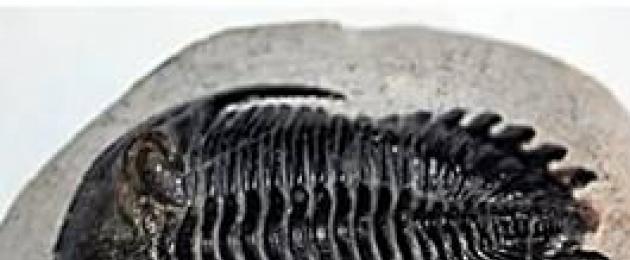
In order to understand the features of the relief, it is necessary to know the geological history of its formation. Scientists, studying the layers of rocks, found out that all of them have come a long way of formation and have a different age. You will learn about this from this lesson, having made a fascinating journey through the history of the development of the earth's crust. And also, learn to read the geochronological table and get acquainted with the geological map. Topic: Geological structure, relief and minerals Lesson: Features of the relief as a result of the geological history of the formation of the territory To understand the pattern of formation of mountains and plains, it is necessary to get acquainted with the history of the geological formation of the territory. The history of the geological development of any territory is learned by studying the age, composition and occurrence of rocks. It is from these data that one can find out what happened to the territory in distant geological epochs, whether the territory was covered by the sea or volcanoes erupted, whether there were deserts or glaciers here. Some plots earth's surface composed of ancient metamorphic rocks, others are young volcanic, and still others are sedimentary. Rocks can lie horizontally or form folds. All rocks have an absolute or relative age. . Relative age is defined by the concepts of "old" and "younger". Sedimentary and volcanic rocks accumulate in horizontal layers and it is therefore natural to assume that the older ones are deeper and the younger ones are closer to the surface. (see fig. 1) Rice. 1. Occurrence of layers of sedimentary rocks help determine relative age and ancient fossils. (see fig. 2)
Rice. 2. Trilobite. Age about 380 million years Powerful strata of sedimentary rocks are formed at the bottom of the oceans. The ocean once covered the vast territories of our planet and various animals lived in it, which died and settled to the bottom, were covered with sand, silt, soft tissues decomposed, and hard tissues became fossils. The more complex the organism is, the younger the rock; the simpler, the older. Absolute age breeds is the number of years that have passed since the formation of these breeds. The study of rocks, extinct remains of animals and plants, made it possible to identify several stages in the formation of the geological history of our planet. These stages are reflected in the geochronological table ("geo" - earth, "chronos" - time, "logos" - doctrine). The geochronological table is a geological record of events taking place on our planet. The table shows the sequence and duration of the change of various geological stages, and the table can also present various geological events in different periods, typical animals, as well as minerals that were formed in different eras. The geochronological table is built on the principle: from ancient to modern, so you need to read it from bottom to top. (see fig. 3)
Rice. 3. Geological table () According to the most significant changes that have occurred on our planet in the geological past, all geological time is divided into two large geological segments - eons: Cryptozoic- time hidden life, Phanerozoic- explicit life time. The aeons include era: Cryptozoic - Archean and Proterozoic, Phanerozoic - Paleozoic, Mesozoic and Cenozoic. (see fig. 4)
Rice. 4. Division of geological time into eons and eras The last three eras: Paleozoic, Mesozoic, Cenozoic are divided into periods, due to the fact that the geological world was very complicated at that time. The names of the periods were given according to where rocks of a given age were first discovered, or according to those rocks that make up a particular area, for example: Permian and Devonian by the name of the area, and Carboniferous, or Cretaceous by rocks. We live in the Cainozoan era, the modern one, which continues to this day. It began about 1.7 million years ago. (see fig. 3) Let's consider some characteristics of geological eras. archaeus and Proterozoic considered the time of hidden life (Cryptose). It is believed that the organic life forms that existed at that time did not have hard skeletons, so they did not leave any traces in the sediments of these eras. (see fig. 5)
Rice. 5. Cryptozoic (Archaean and Proterozoic) () The time of domination of invertebrates, crustaceans, insects, molluscs. In the late Paleozoic, the first vertebrates appeared - amphibians, fish. The plant kingdom was dominated by algae and pselophytes . Later, horsetails and club mosses appear. (see fig. 6)
Rice. 6. Paleozoic () In the Mesozoic, large reptiles dominate, and in flora gymnosperms .(see fig. 7)
In the Cenozoic - the dominance of angiosperms flowering plants, the appearance of mammals and, finally, humans. (see fig. 8)
Rice. 8. Cenozoic () In each of the geological epochs and periods, the accumulation of the chemical and mechanical composition of rocks took place. In order to find out what rocks this or that territory of our country is composed of, we can use the geological map of Russia. (see fig.9)
Rice. 9. Geological map of Russia () Geological map contains information about the age of rocks, about minerals. Information on the map is shown in different colors. If you look at the geological map, you will see that the most ancient rocks form the territory of Transbaikalia and the Kola Peninsula. Different periods are shown in different colors, for example, the Carboniferous rocks are shown in grey, while the Mesozoic rocks are shown in green. Analyzing the geological map, one can pay attention to the fact that the East European Plain is composed of rocks of the Paleozoic era, and only in the Far North-West we see outcrops of rocks of the Archean and Proterozoic period. The West Siberian lowland is composed of young deposits of the Paleogene and Neogene. Using geological maps, you can get information about minerals, as well as predict their search. The geological age of our planet is approximately 4.7 billion years. It was during this period that the core, the mantle, were formed as a result of the differentiation of matter. (see fig. 10)
Rice. 10. Internal structure Earth The earth's crust is broken into blocks - lithospheric plates. Moving through the mantle, lithospheric plates changed the outlines of continents and oceans. (see fig. 11)
Rice. 11. Lithospheric plates There were periods when the lithospheric plates descended, and then the land area decreased, and the area of the World Ocean increased. Such eras, more peaceful in geological terms, were called epochs of the seas. They alternated with geologically more turbulent and shorter periods, which were called epochs of land. These epochs were accompanied by active volcanism and mountain building.
Homework
Other tutorials on this topic
Find out more on the topic
The planets are closely related to each other, because the geology of the Earth begins with the formation of the crust. The age of the earth's lithosphere, as evidenced by the most ancient rocks, is more than $3.5 billion years. On land, two main types of tectonic structures are distinguished - platforms and geosynclines, which differ significantly from each other. Definition 1 Platforms- these are stable, vast areas of the earth's crust, consisting of a crystalline basement and a sedimentary cover of younger rocks On the platforms, as a rule, there are no rock formations, vertical movements have a very low speed, there are no modern active volcanoes, and earthquakes are very rare. The formation of the crystalline basement of the Russian platform dates back to the Archean and Proterozoic eras, which is about $2 billion years ago. At this time, powerful mountain-building processes took place on the earth. The result of these processes were mountains, composed of ancient rocks crumpled into folds such as gneisses, quartzites, crystalline schists. By the beginning of the Paleozoic, these mountain formations leveled off, and their surface experienced slow fluctuations. If the surface fell below the level of the ancient ocean, a marine transgression began with the accumulation of marine sediments. There was a formation of sedimentary rocks - limestones, marls, dark-colored clays, salts. On land, when it rose and was freed from water, there was an accumulation of red sands and sandstones. With the accumulation of sedimentary material in shallow lagoons and lakes, brown coals and salts accumulated. In the Paleozoic and Mesozoic eras, ancient crystalline rocks turned out to be overlain by a sedimentary cover of a fairly large thickness. To determine the composition, thickness, properties of these rocks, geologists drill wells in order to get a certain amount of core from it. Experts can explore the geological structure by studying the natural outcrop of rocks. Today, along with traditional geological methods, geophysical and aerospace research methods are used. The rise and fall of the territory of Russia, the formation of continental conditions are due to tectonic movements, the causes of which are not yet completely clear. The only thing that is indisputable is that they are connected with the processes that take place in the bowels of the Earth. Geologists distinguish the following tectonic processes:
General features of the relief of RussiaDefinition 2 Relief- this is a set of irregularities on the surface of the Earth, including oceans, seas. Relief renders big influence on the formation of climate, the distribution of plants and animals, on the economic life of man. Relief, as geographers say, is the framework of nature, so its study usually begins with the study of relief. The relief of Russia is surprisingly diverse and quite complex. Majestic mountain ranges, ancient ridges, cones of volcanoes, intermountain basins are replacing the endless plain expanses. physical map Russia and images taken from space show well the general patterns of the country's orographic pattern. Definition 3 Orography- the relative position of the relief relative to each other. Orography of Russia:
On the territory of Russia there are two largest plains in the world - East European or Russian and West Siberian. Relief of the Russian Plain hilly, with alternating high and low areas. The northeast of the Russian Plain is higher - more than $400 m above the level of the World Ocean. The Caspian lowland, located in its southern part, is the lowest part - $ 28 $ m below the level of the World Ocean. The average heights of the Russian Plain reach about $170$ m. Relief of the West Siberian Lowland does not differ in variety. The lowlands lie mostly $100$ m below the level of the World Ocean. Its average height is $120$ m, and only in the northwest the height rises to $200$ m. The North Sosvinskaya Upland is located here. The watershed between the plains is Ural ridge The ridge itself does not have great heights, and its width reaches $150$ km. The top of the Urals is the town of Narodnaya, with a height of $1895$ m. The Ural Mountains stretch from north to south for $2000$ km. The third largest plain in Russia is located between the Lena and the Yenisei - this high plain is called Central Siberian Plateau. The average height of the plateau above the ocean level is $480$ m. Its maximum height is located in the area of the Putorana plateau - $1700$ m. Central Yakutsk plain, and in the north it descends as a step into North Siberian lowland. The mountainous regions of Russia occupy the southeastern outskirts of the country. To the south-west of the Russian Plain, between the Black and Caspian Seas, the highest mountains of Russia are located - caucasian. Here is the highest point of the country - Elbrus, the height of which is $5642$ m. From west to east along the southern outskirts of Russia, they go further Altai Mountains and Sayans. The tops of which, respectively, are the cities of Belukha and Munku-Sardyk. Gradually, these mountains pass into the ranges of Cisbaikalia and Transbaikalia. Stanovoy Ridge connects them with the ranges of the northeast and east of Russia. Here are located medium-high and low ranges - Chersky, Verkhoyansky, Suntar-Khayata, Dzhugdzhur. In addition to them, there are numerous highlands here - Yano-Oymyakonskoe, Kolyma, Koryakskoe, Chukchi. In the southern part of the Far East of the country, they are connected with low and medium-altitude ridges. Amur and Primorye, for example, Sikhote-Alin. Mountains in the extreme east of the country Kamchatka and the Kuriles. All the active volcanoes of the country are located here, and the highest of the active volcanoes is Klyuchevskaya Sopka. Mountains occupy $10$% of the territory of Russia. Minerals of RussiaRussia, in terms of mineral reserves, occupies a leading position in the world. Today, more than $200$ of deposits are known, the total value of which is estimated at $300 trillion. dollars. Certain types of Russian minerals in world reserves are:
In the bowels of Russia there are combustible, ore, non-metallic minerals. Fuels include:
Ore minerals are represented by a variety of ores. Among them:
By production diamonds in world volume, Russia accounts for $25$% and only South Africa produces more than Russia. From non-metallic Minerals Russia produces precious stones of both organic and mineral origin, and a wide range of building minerals.
Most Discussed
 |