Components of the geographic envelope and their interaction.
The atmosphere, lithosphere, hydrosphere and biosphere - the four shells of the globe are in complex interaction, interpenetrate each other. Together they make up geographical envelope.
Life develops in the geographical shell, the activity of water, ice, wind manifests itself, soils, sedimentary rocks are formed.
The geographic envelope is an area of complex interpenetration, interaction of cosmic and terrestrial forces. It continues to develop and become more complex as a result of the interaction of living and inanimate nature.
The upper boundary of the geographic shell corresponds to the tropopause - the transitional layer between the troposphere and the stratosphere. Above the equator, this layer is located at an altitude of 16-18 km, and at the poles - 8-10 km. At these heights, the processes generated by the interaction of the geospheres fade and stop. There is practically no water vapor in the stratosphere, there is no vertical movement of air, and temperature changes are not associated with the influence of the earth's surface. Life is impossible here.
The lower boundary on land runs at a depth of 3-5 km, i.e., where the composition and properties of rocks change, there is no liquid water and living organisms.
The geographic shell of the Earth is an integral material system, qualitatively different from other geospheres of the Earth. Its integrity is determined by the continuous interaction of solid, liquid and gaseous, and with the emergence of life - and living substances. All components of the geographic shell interact using the solar energy coming to the Earth and the energy of the Earth's internal forces.
The interaction between the geospheres of the Earth within the geographic envelope occurs as a result of the circulation of substances (water, carbon, oxygen, nitrogen, carbon dioxide and etc.).
All components of the geographic envelope are in complex relationships. A change in one component necessarily causes a change in others.
Rhythm of phenomena in the geographical shell. The geographic envelope of the Earth is constantly changing, the relationship between its individual components is becoming more complicated. These changes occur in time and space. In nature, there are rhythms of different duration. Short, diurnal and annual rhythms are especially important for living organisms. Their periods of rest and activity are consistent with these rhythms. circadian rhythm(change of day and night) is due to the rotation of the Earth around its axis; annual rhythm(change of seasons) - the revolution of the Earth around the Sun. The annual rhythm is manifested in the existence of periods of rest and vegetation in plants, in molting and migration of animals, in some cases - in hibernation, reproduction. The annual rhythm in the geographical envelope depends on the latitude of places: in equatorial latitudes it is less pronounced than in temperate or polar ones.
Daily rhythms proceed against the background of annual ones, annual ones - against the background of long-term ones. There are also age-old, long-term rhythms, such as climate change (cooling - warming, desiccation - moistening).
Changes in the geographical envelope also occur as a result of the movement of the continents, the advance and retreat of the seas, in the course of geological processes: during erosion and accumulation, the work of the sea, volcanism. On the whole, the geographical shell is developing progressively: from the simple to the complex, from the lowest to the highest.
Zoning and sectoring of the geographic envelope.
The most important structural feature of the geographic shell is its zoning. Zoning law was formulated by the great Russian natural scientist V.V. Dokuchaev, who wrote that the location of our planet relative to the Sun, its rotation and sphericity affect the climate, vegetation and animals, which are distributed over the earth's surface in the direction from north to south in a strictly defined order .
Zoning is better expressed in the vast plains. However, the boundaries of geographical zones rarely coincide with parallels. The fact is that the distribution of zones is influenced by many other natural factors (for example, relief). Significant differences can be observed within the zone. This is explained by the fact that zonal processes are superimposed on azonal ones, due to internal factors that are not subject to the laws of zoning (relief, distribution of land and water).
The largest zonal divisions of the geographic envelope - geographic zones, they are distinguished by radiation balance(arrival-expenditure of solar radiation) and the nature of the general circulation of the atmosphere. The following geographic zones exist on Earth: equatorial, subequatorial (northern and southern), tropical (northern and southern), subtropical (northern and southern), temperate (northern and southern), subpolar (subarctic and subantarctic), polar (arctic and antarctic) .
Geographical belts do not have a regular ring shape, they expand, narrow, bend under the influence of continents and oceans, sea currents, mountain systems.
On the continents and oceans, the geographical zones are qualitatively different. On the oceans, they are well expressed at depths up to 150 m, weakly - up to a depth of 2000 m.
Under the influence of the oceans on the continents within the geographical zones are formed longitudinal sectors(in temperate, subtropical and tropical belts), oceanic and continental.
On the plains within geographical zones, they distinguish natural areas(Fig. 45). In the continental sector of the temperate zone within the East European Plain, these are zones of forests, forest-steppes, steppes, semi-deserts, and deserts. Natural zones are called subdivisions of the earth's surface, characterized by similar soil-vegetative and climatic conditions. The main factor in the formation of soil and vegetation cover is the ratio of temperatures and moisture.
Rice. 45. The main biozones of the Earth
Vertical explanation. Vertically, natural components change at a different rate than horizontally. When climbing up in the mountains, the amount of precipitation and the light regime change. The same phenomena are expressed in a different way on the plain. The different exposure of the slopes is the reason for the uneven distribution of temperature, moisture, and soil and vegetation cover. The causes of latitudinal zonality and vertical zonality are different: zonality depends on the angle of incidence of the sun's rays and the ratio of heat and moisture; vertical zonality - from a decrease in temperature with height and degree of moisture.
Almost every mountainous country on Earth has its own peculiarities of vertical zonality. In many mountainous countries, the mountain tundra belt falls out and is replaced by a belt of mountain meadows.

Rice. 46. Vegetation change depending on the latitude and altitude of the area
The altitudinal zonality begins from the zone located at the foot of the mountain (Fig. 46). The most important factor in the distribution of the height of the belts is the degree of moisture.
| |
§ 40. Circulation of matter and energy in the biosphere§ 42. Natural areas of Russia
How is the exchange of substances between the outer shells of the Earth?
1. Interaction of the earth's shells. Geographic cover. It is known that the outer shells of the Earth - the atmosphere, hydrosphere, lithosphere and biosphere develop in close relationship with each other. Their main constituents are gas, liquid and solid substances, being mixed, they pass from one state to another. Therefore, at the points of contact between the shells, their constant interaction is observed. For example, let's observe the relationship between the atmosphere and the biosphere. Air is a necessary condition for the life of all organisms. People and animals breathe oxygen in the air, plants absorb carbon dioxide, producing organic matter. At the same time, the composition of gases in the atmosphere is closely related to the life of organisms. (Remember how oxygen is formed in the air.)
Living organisms subject the upper layer of the atmosphere to complex changes. They are involved in the process of weathering rocks. The remains of plants and animals create organic rocks in the earth's crust. In turn, various substances of the earth's crust are part of organisms. The top layer of the lithosphere is living environment for organisms.
The atmosphere and lithosphere are also closely related. You know that the atmosphere is heated by the sun's rays hitting the earth's surface. In this regard, a regularity of changes in air temperature in the troposphere with height appeared. Dust and other small particles rising from the earth's surface affect the transparency of the air and the conditions for heating the upper layer of the earth's surface. Around small particles that have risen into the air, water vapor thickens, clouds form, etc.
Earlier we considered the interaction of the earth's shells. In fact, such interaction is not only bilateral, but also multilateral.
As a result of close contact and mutual influence of the atmosphere, lithosphere and hydrosphere, a special shell of the Earth was formed - the geographic shell. She creates the necessary conditions for the emergence and development of life on Earth. At the present stage of the Earth's development, living organisms have reached such a level that they constitute a separate shell - the biosphere.
The geographic shell includes the upper layer of the lithosphere changed under the influence of other shells, the lower layer of the atmosphere, the entire hydrosphere and the biosphere.
The geographical envelope is characterized by the following features:
1) each earthly shell consists of only one substance: the atmosphere - from air, the hydrosphere - from water, the lithosphere - from rocks, the biosphere - from living organisms. And the material composition of the geographic shell is very complex. It includes all the substances mentioned earlier. Therefore, it is characterized as a complex shell;
2) organisms live only in a geographical envelope. Life does not extend to the upper layers of the atmosphere and the deep interior of the lithosphere;
3) the heat that comes to the Earth with the sun's rays is completely concentrated in the geographic envelope. Heat is characterized by latitudinal distribution. Such latitudinal zonality is completely absent in upper layers atmosphere or deep parts of the lithosphere;
4) although the geographical envelope consists of separate components, it is an integral system. Changes that occur in some areas that are part of the geographic envelope cause changes in others. For example, you know that the emergence and development of life on the earth's surface contributed to changes in the atmosphere, hydrosphere and lithosphere.
2. Components of nature. Natural complex. The geographical envelope consists of rocks, air, water, soil, plants and animals. These components of the geographic shell are called natural components, or geographical components (component in Latin - component).
The totality of the natural components of any territory constitutes an integral system. This system is called the natural complex, or geographical complex.
Each component natural complex closely interconnected with others (Fig. 82).
Rice. 82. The relationship between natural components.
A change in one of them necessarily leads to a change in the others.
For example, let's imagine a natural complex of a sandy desert. Abundance of sand, rare thorny plants, animals adapted to life in the sands. Now let's pay attention to how this natural complex changes if we dig a canal here and let the river water flow. Seeping water will raise the groundwater level and form salt marshes and lakes. Reeds, meadows, shrub groves will grow on the banks of the canal, around the lakes. Instead of various animals of the sandy deserts, tugai animals will appear and take root. Due to changes in humidity and the nature of plants, floodplain soil will form instead of sand. The climate of the area will noticeably change, humidity will increase and the heat will subside.
The geographic envelope is the largest natural complex on the globe (the largest a complex system). It consists of an interdependent system of natural complexes. The next natural complexes after the geographical are the continents and the Ocean. Numerous rivers flowing into the Ocean bring with them a large amount of rocks. (Remember how mountains sink.) Also, winds from the Ocean carry clouds and precipitation onto land. (How does the water cycle occur in nature?)
The exchange of matter between the land and the ocean unites them into an integral planetary geographical system. Since the surface of the Ocean is monotonous, from the outside it seems that it is no longer divided into natural complexes. However, it is not. In each part of the Ocean, water temperature, salinity, plants and animals, microorganisms differ. This makes it possible to divide the surface of the Ocean into natural complexes.
The natural complexes of the land surface, on the contrary, are well traced. The land is divided into natural countries, and they are divided into even smaller parts. West Siberian Plain, Saryarka, Tien Shan are examples of natural countries. Small natural complexes: floodplain, grove, lake shore, ravine, etc.
1. What is called a geographic shell?
2. Why are the atmosphere and lithosphere not completely included in the geographic envelope?
3. What is the main difference between the geographic shell and other earthly shells?
4.What is natural ingredients?
5. How is a natural complex formed?
6. Give some examples of natural complexes in your area?
7. How do you understand the system internal communications natural complexes?
8. Analyze according to Figure 82 the two-way relationship between the components of nature (water and air, soil and plants, etc.).
nine*. Analyze the two-way relationship between the atmosphere and the hydrosphere.
Geography is the science of the internal and external structure of the Earth, studying the nature of all continents and oceans. The main object of study are various geospheres and geosystems.
Introduction
The geographic shell or GO is one of the basic concepts of geography as a science, introduced into circulation at the beginning of the 20th century. It denotes the shell of the entire Earth, a special natural system. The geographic shell of the Earth is called an integral and continuous shell, consisting of several parts that interact with each other, penetrate each other, constantly exchange substances and energy with each other.

Fig 1. Geographical shell of the Earth
There are similar terms, with narrow meanings, used in the writings of European scientists. But they don't mean natural system, only a set of natural and social phenomena.
Stages of development
The geographic shell of the earth has gone through a number of specific stages in its development and formation:
- geological (prebiogenic)– the first stage of formation, which began about 4.5 billion years ago (lasted about 3 billion years);
- biological– the second stage, which began about 600 million years ago;
- anthropogenic (modern)- a stage that continues to this day, which began about 40 thousand years ago, when humanity began to exert a noticeable influence on nature.
The composition of the geographic shell of the Earth
Geographic envelope- this is a system of the planet, which, as you know, has the shape of a ball, flattened on both sides by caps of the poles, with long equator more than 40 t km. GO has a certain structure. It consists of interconnected environments.
TOP 3 articleswho read along with this
Some experts divide civil defense into four areas (which, in turn, are also divided):
- atmosphere;
- lithosphere;
- hydrosphere;
- biosphere.
In any case, the structure of the geographic envelope is not arbitrary. It has clear boundaries.
Upper and lower bounds
In the entire structure of the geographic envelope and geographic environments, a clear zoning can be traced.
The law of geographical zoning provides not only for the division of the entire shell into spheres and environments, but also for the division into natural zones of land and oceans. It is interesting that such a division naturally repeats itself in both hemispheres.
Zoning is due to the nature of the distribution of solar energy over latitudes and the intensity of moisture (different in different hemispheres, continents).
Naturally, it is possible to determine the upper boundary of the geographic envelope and the lower one. Upper bound located at an altitude of 25 km, and bottom line The geographic envelope runs at a level of 6 km under the oceans and at a level of 30-50 km on the continents. Although, it should be noted that the lower limit is conditional and there are still disputes over its setting.
Even if we take the upper boundary in the region of 25 km, and the lower one in the region of 50 km, then, compared to the total size of the Earth, we get something like a very thin film that covers the planet and protects it.
Basic laws and properties of the geographical shell
Within these boundaries of the geographical envelope, the basic laws and properties that characterize and determine it operate.
- Interpenetration of components or intra-component movement- the main property (there are two types of intra-component movement of substances - horizontal and vertical; they do not contradict and do not interfere with each other, although in different structural parts of GO the speed of movement of components is different).
- Geographic zonation- the basic Law.
- Rhythm- the frequency of all natural phenomena (daily, annual).
- The unity of all parts of the geographical shell due to their close relationship.
Characteristics of the Earth's shells included in the GO
Atmosphere
The atmosphere is important for keeping warm, and therefore life on the planet. It also protects all living things from ultraviolet radiation, affects soil formation and climate.
The size of this shell is from 8 km to 1 t km (and more) in height. It consists of:
- gases (nitrogen, oxygen, argon, carbon dioxide, ozone, helium, hydrogen, inert gases);
- dust;
- water vapor.
The atmosphere, in turn, is divided into several interconnected layers. Their characteristics are presented in the table.
All shells of the earth are similar. For example, they contain all types of aggregate states of substances: solid, liquid, gaseous.

Fig 2. The structure of the atmosphere
Lithosphere
The hard shell of the earth, the earth's crust. It has several layers, which are characterized by different power, thickness, density, composition:
- upper lithospheric layer;
- sigmatic sheath;
- semi-metallic or ore shell.
The maximum depth of the lithosphere is 2900 km.
What is the lithosphere made of? From solids: basalt, magnesium, cobalt iron and other.
Hydrosphere
The hydrosphere is made up of all the waters of the Earth (oceans, seas, rivers, lakes, swamps, glaciers and even groundwater). It is located on the surface of the Earth and occupies more than 70% of the space. Interestingly, there is a theory according to which in the thickness earth's crust contain large reserves of water.
There are two types of water: salt and fresh. As a result of interaction with the atmosphere, during condensate, the salt evaporates, thereby providing the land with fresh water.

Fig 3. Earth's hydrosphere (view of the oceans from space)
Biosphere
The biosphere is the most "living" shell of the earth. It includes the entire hydrosphere, the lower atmosphere, the land surface and the upper lithospheric layer. It is interesting that living organisms inhabiting the biosphere are responsible for the accumulation and distribution of solar energy, for the migration processes of chemicals in the soil, for gas exchange, and for redox reactions. We can say that the atmosphere exists only thanks to living organisms.

Fig 4. Components of the Earth's biosphere
Examples of the interaction of media (shells) of the Earth
There are many examples of media interaction.
- During the evaporation of water from the surface of rivers, lakes, seas and oceans, water enters the atmosphere.
- Air and water, penetrating through the soil into the depths of the lithosphere, makes it possible for vegetation to rise.
- Vegetation provides photosynthesis by enriching the atmosphere with oxygen and absorbing carbon dioxide.
- From the surface of the earth and oceans, the upper layers of the atmosphere are heated, forming a climate that provides life.
- Living organisms, dying, form the soil.
What have we learned?
The concept of "geographical envelope" is controversial, the definition of the term is rather complicated, but, despite the fact that its use is periodically criticized, it is still used. At geography lessons in the 7th grade, the structure of the geographic shell is analyzed in detail, the complex process of interaction between environments is briefly described, it is explained that the geographic shell is an object of study of geography and branch sciences.
Topic quiz
Report Evaluation
Average rating: 4.6. Total ratings received: 616.
Introduction
Conclusion
Introduction
The geographic envelope of the Earth (synonyms: natural-territorial complexes, geosystems, geographical landscapes, epigeosphere) is the sphere of interpenetration and interaction of the lithosphere, atmosphere, hydrosphere and biosphere. It has complex spatial differentiation. The vertical thickness of the geographic envelope is tens of kilometers. The integrity of the geographic envelope is determined by the continuous energy and mass exchange between the land and the atmosphere, the World Ocean and organisms. Natural processes in the geographic envelope are carried out due to the radiant energy of the Sun and the internal energy of the Earth. Within the geographic shell, humanity arose and is developing, drawing resources from the shell for its existence and influencing it.
The geographic shell was first defined by P. I. Brounov as early as 1910 as “the outer shell of the Earth”. This is the most complex part of our planet, where the atmosphere, hydrosphere and lithosphere come into contact and interpenetrate. Only here is possible the simultaneous and stable existence of matter in solid, liquid and gaseous states. In this shell, the absorption, transformation and accumulation of the radiant energy of the Sun takes place; only within it possible occurrence and the spread of life, which, in turn, was a powerful factor in the further transformation and complication of the epigeosphere.
The geographical shell is characterized by integrity, due to the connections between its components, and uneven development in time and space.
The uneven development in time is expressed in the directed rhythmic (periodic - daily, monthly, seasonal, annual, etc.) and non-rhythmic (episodic) changes inherent in this shell. As a result of these processes, different ages of individual sections of the geographical envelope, the heredity of the course of natural processes, the preservation of relict features in existing landscapes are formed. Knowledge of the basic patterns of development of the geographic envelope makes it possible in many cases to predict natural processes.
The doctrine of geographical systems (geosystems) is one of the main fundamental achievements of geographical science. It is still being actively developed and discussed. Since this doctrine has not only a deep theoretical meaning as a key basis for the purposeful accumulation and systematization of factual material in order to obtain new knowledge. Its practical significance is also great, since it is precisely such a systematic approach to considering the infrastructure geographical objects underlies geographical zoning territories, without which it is impossible to identify and solve either locally, and even more so globally, any problems related to one degree or another to the interaction of man, society and nature: neither ecological, nor nature management, nor in general optimization of the relationship between mankind and the natural environment.
aim control work is the consideration of the geographical shell in the perspective of modern ideas. To achieve the goal of the work, a number of tasks should be identified and solved, the main of which will be:
1 consideration of the geographic envelope as a material system;
2 consideration of the main regularities of the geographic envelope;
3 determination of the reasons for the differentiation of the geographic envelope;
4 consideration of physical-geographical zoning and determination of the system of taxonomic units in physical geography.
1. Geographical shell as a material system, its boundaries, structure and qualitative differences from other earthly shells
According to S.V. Kalesnik1, the geographic shell "is not just a physical or mathematical surface, but a complex complex that has arisen and develops under the influence of interconnected and interpenetrating processes that unfold on land, in the atmosphere, waters and the organic world."
Giving the definition of the geographical shell, S.V. Kalesnik emphasized: 1) its complexity, 2) multicomponent nature - the natural shell consists of parts - the earth's crust, which forms landforms, waters, atmosphere, soils, living organisms (bacteria, plants, animals, humans); 3) volume. "Shell" is a three-dimensional concept.
It should be borne in mind that the geographic envelope is characterized by a number of specific features. It is distinguished primarily by a large variety of material composition and types of energy characteristic of all component shells - the lithosphere, atmosphere, hydrosphere and biosphere. Through common (global) cycles of matter and energy, they are united into an integral material system. To know the patterns of development of this unified system is one of the most important tasks of modern geographical science.
The geographic envelope is the area of interaction between intraplanetary (endogenous) and external (exogenous) cosmic processes, which are carried out with the active participation of organic matter2.
The dynamics of the geographic envelope depends entirely on the energy of the earth's interior in the zone of the outer core and asthenosphere and on the energy of the Sun. Tidal interactions of the Earth-Moon system also play a certain role.
The projection of intraplanetary processes onto the earth's surface and their subsequent interaction with solar radiation is ultimately reflected in the formation of the main components of the geographic shell of the upper crust, relief, hydrosphere, atmosphere and biosphere. Current state geographical shell is the result of its long evolution, which began with the emergence of the planet Earth.
Scientists identify three stages in the development of the geographic shell: the first, the longest (about 3 billion years)3, was characterized by the existence of the simplest organisms; the second stage lasted about 600 million years and was marked by the appearance higher forms living organisms; the third stage is modern. It began about 40 thousand years ago. Its peculiarity is that people are increasingly beginning to influence the development of the geographic envelope, and, unfortunately, negatively (destruction of the ozone layer, etc.).
The geographic shell is characterized by a complex composition and structure. The main material components of the geographic shell are the rocks that make up the earth's crust (with their shape - relief), air masses, water accumulations, soil cover and biocenoses; in the polar latitudes and high mountains, the role of ice accumulations is essential. The main energy components are gravitational energy, the internal heat of the planet, the radiant energy of the Sun and energy cosmic rays. Despite the limited set of components, their combinations can be very diverse; it also depends on the number of terms included in the combination and on their internal variations (since each component is also a very complex natural combination), and most importantly, on the nature of their interaction and relationships, i.e., on the geographical structure.
A.A. Grigoriev held the upper limit of the geographic envelope (GO) at an altitude of 20-26 km above sea level, in the stratosphere, below the layer of maximum ozone concentration. Ultraviolet radiation, detrimental to living things, is intercepted by the ozone screen.
Atmospheric ozone is formed mainly above 25 km. It enters the lower layers due to turbulent mixing of air and vertical movements of air masses. The density of O3 is low near the earth's surface and in the troposphere. Its maximum is observed at altitudes of 20-26 km. The total ozone content X in a vertical column of air ranges from 1 to 6 mm when brought to normal pressure (1013, 2mbar) at t = 0oC. The value of X is called the reduced thickness of the ozone layer or the total amount of ozone.
Below the boundary of the ozone screen, air movement is observed due to the interaction of the atmosphere with land and the ocean. The lower boundary of the geographic shell, according to Grigoriev, passes where tectonic forces cease to act, that is, at a depth of 100-120 km from the surface of the lithosphere, along the upper part of the subcrustal layer, which greatly affects the formation of the relief.
S.V. Kalesnik places an upper bound on the G.O. just like A.A. Grigoriev, at the level of the ozone screen, and the lower one - at the level of occurrence of the sources of ordinary earthquakes, that is, at a depth of not more than 40-45 km and not less than 15-20 km. This depth is the so-called zone of hypergenesis (Greek hyper- above, above, genesis- origin). This is a zone of sedimentary rocks that arise in the process of weathering, changes in igneous and metamorphic rocks of primary origin.
The views of D. L. Armand differ from these ideas about the boundaries of civil defense. D.L. Armand in the composition of the geographical sphere includes the troposphere, hydrosphere and the entire earth's crust (the silicate sphere of geochemists), located under the oceans at a depth of 8-18 km and under high mountains at a depth of 49-77 km. In addition to the actual geographical sphere, D.L. Armand proposes to distinguish between the “Great Geographical Sphere”, including in it the stratosphere, extending to a height of up to 80 km above the ocean, and the eclogite sphere or sima, that is, the entire thickness of the lithosphere, with a lower horizon of which (700-1000 km) are associated with deep-focus earthquakes.
Obviously, with the views of D.L. Armand cannot agree. Such an interpretation of GO does not correspond to the content of this concept. It is difficult to see in this conglomerate of spheres - from the stratosphere to the eclogite sphere - a single complex, new system with their special, individual qualities. The subject of physical geography becomes vague, devoid of concrete content, and physical geography itself, as a science, loses its boundaries, merging with other earth sciences.
Qualitative differences of the geographic shell from other shells of the Earth: the geographic shell is formed under the influence of both terrestrial and cosmic processes; exceptionally rich in various types of free energy; the substance is present in all states of aggregation; the degree of aggregation of matter is extremely diverse - from free elementary particles through atoms, ions, molecules to chemical compounds and the most complex biological bodies; concentration of heat flowing from the Sun; presence of human society.
PAGE_BREAK--
2. Circulation of matter and energy in the geographic envelope
Due to the contradictory interaction of GO components, a multiplicity of systems arises. For example, atmospheric precipitation is a climatic process, the runoff of precipitation is a hydrological process, moisture transpiration by plants is biological process. This example clearly shows the transition of one process to another. And all together this is an example of a large water cycle in nature. The geographical shell, its unity, integrity exists due to the extremely intense circulation of substances and the energy associated with it. Cycles can be considered as extremely diverse forms of interaction of components (atmosphere - volcanism). The efficiency of cycles in nature is colossal, since they provide the repetition of the same processes and phenomena, high overall efficiency with a limited amount of the initial substance involved in these processes. Examples: large and small water cycle; atmospheric circulation; sea currents; rock cycles; biological cycles.
According to the degree of complexity, the cycles are different: some are reduced mainly to circular mechanical movements, others are accompanied by a change state of aggregation substances, others are accompanied by chemical transformation.
Assessing the cycle by its initial and final links, we see that the substance that has entered the cycle often undergoes a rearrangement in the intermediate links. Therefore, the concept of circulation is included in the concept of the interchange of matter and energy.
All cycles are not cycles in the exact sense of the word. They are not completely closed, and the final stage of the cycle is by no means identical to its initial stage.
Due to the absorption of solar energy, a green plant assimilates carbon dioxide and water molecules. This assimilation results in organic matter while free oxygen is released.
The gap between the final and initial stages of the cycle forms a vector of directional change, that is, development.
The basis of all cycles in nature is migration and redistribution chemical elements. The ability of elements to migrate depends on their mobility.
The order of air migration is known: hydrogen > oxygen > carbon > nitrogen. It shows how quickly the atoms of elements can enter into chemical compounds. O2 is exceptionally active, so the migration of most other elements depends on it.
The degree of mobility of water migrants is not always explained by their own characteristics. There are other significant reasons as well. The migration ability of elements is weakened by their absorption by organisms during biogenic accumulation, absorption by soil colloids, that is, the processes of adsorption (lat. - absorption) and sedimentation. The processes of mineralization of organic compounds, dissolution and desorption (the reverse process of adsorption) enhance the migration ability.
3. The main regularities of the geographic shell: the unity and integrity of the system, the rhythm of phenomena, zonality, azonal
Law, as V.I. Lenin wrote, is a relationship between entities. The essence of geographical phenomena is of a different nature than the essence of, for example, social or chemical objects, so the relationship between geographical objects act as specific laws of the geographical form of movement.
The geographical form of movement is a specific interaction between the atmosphere, hydrosphere, lithosphere, biosphere, on the basis of which the whole variety of natural complexes is formed and exists.
So, geographic integrity- the most important regularity, on the knowledge of which the theory and practice of modern environmental management is based. Accounting for this regularity makes it possible to foresee possible changes in the nature of the Earth (a change in one of the components of the geographic envelope will necessarily cause a change in others); to give a geographical forecast of the possible results of human impact on nature; carry out a geographical examination of various projects related to economic use certain territories.
The geographic shell is also characterized by another characteristic pattern - rhythm of development, those. recurrence in time of certain phenomena. In the nature of the Earth, rhythms of different durations have been identified - daily and annual, intra-secular and super-secular rhythms. The daily rhythm, as you know, is due to the rotation of the Earth around its axis. The daily rhythm is manifested in changes in temperature, pressure and humidity, cloudiness, wind strength; in the phenomena of ebbs and flows in the seas and oceans, the circulation of breezes, the processes of photosynthesis in plants, the daily biorhythms of animals and humans.
The annual rhythm is the result of the Earth's movement in orbit around the Sun. These are the change of seasons, changes in the intensity of soil formation and destruction of rocks, seasonal features in the development of vegetation and human economic activity. Interestingly, different landscapes of the planet have different daily and annual rhythms. Thus, the annual rhythm is best expressed in temperate latitudes and very weakly in the equatorial zone.
Of great practical interest is the study of longer rhythms: 11-12 years, 22-23 years, 80-90 years, 1850 years and longer, but, unfortunately, they are still less studied than daily and annual rhythms.
A characteristic feature of differentiation (spatial heterogeneity, separation) of GO is zoning (a form of spatial pattern of location), that is, a regular change in all geographic components and complexes in latitude, from the equator to the poles. The main reasons for zonality are the sphericity of the Earth, the position of the Earth relative to the Sun, the incidence of sunlight on the earth's surface at an angle that gradually decreases on both sides of the equator.
Belts (the highest levels of latitudinal physical-geographical division) are divided into radiation or solar lighting and thermal or climatic, geographical. The radiation belt is determined by the amount of incoming solar radiation, which naturally decreases from low to high latitudes.
For the formation of thermal (geographical) belts, not only the amount of incoming solar radiation is important, but also the properties of the atmosphere (absorption, reflection, settlement of radiant energy), the albedo of the green surface, the transfer of heat by sea and air currents. Therefore, the boundaries of thermal zones cannot be combined with parallels. - 13 climatic or thermal zones.
A geographical zone is a set of landscapes of one geographical zone.
The boundaries of geographic zones are determined by the ratio of heat and moisture. This ratio depends on the amount of radiation, as well as the amount of moisture in the form of precipitation and runoff, which are only partially tied to latitude. That is why the zones do not form continuous bands, and their extension along the parallels is rather special case, how common law.
Discovery of V.V. Dokuchaev (Russian Chernozem, 1883) of geographical zones as integral natural complexes was one of the largest events in the history of geographical science. After that, for half a century, geographers were engaged in concretizing this law: they specified the boundaries, singled out sectors (that is, deviations of the boundaries from theoretical ones), etc.
In the geographic envelope, in addition to zonal processes associated with the distribution of solar heat on the earth's surface, azonal processes are of great importance, depending on the processes occurring inside the Earth4. Their sources are: the energy of radioactive decay, mainly uranium and thorium, the energy of gravitational differentiation produced in the process of reducing the radius of the Earth during the rotation of the Earth, the energy of tidal friction, the energy of interatomic bonds of minerals.
Azonal influences on the geographic shell are manifested in the formation of high-altitude geographical zones, in mountains that violate latitudinal geographic zonality, and in the division of geographical zones into sectors, and zones into provinces.
The formation of sector and provinciality in landscapes is explained by three reasons: a) the distribution of land and sea, b) the relief of the green surface, c) the composition of rocks.
The distribution of land and sea affects the azonal character of GO processes through the degree of climate continentality. There are many methods for determining the degree of climate continentality. Most scientists determine this degree through the annual amplitude of average monthly air temperatures.
The influence of the relief, unevenness of the earth's surface and the composition of rocks on landscapes is well known and understandable: at the same latitude in the mountains and on the plains of the forest and steppe; known moraine and karst landscapes associated in origin with the composition of rocks.
4. Differentiation of the geographic envelope. Geographical zones and natural areas
The largest zonal divisions of the geographic shell - geographic zones. They stretch, as a rule, in the latitudinal direction and, in essence, coincide with the climatic zones. Geographical zones differ from each other in temperature characteristics, as well as common features atmospheric circulation. On land, the following geographical zones are distinguished:
equatorial - common to the northern and southern hemispheres;
subequatorial, tropical, subtropical and temperate - in each hemisphere;
subantarctic and antarctic belts - in the southern hemisphere.
Belts similar in name were also found in the World Ocean. The zonation (zonality) in the ocean is reflected in the change from the equator to the poles of properties surface water(temperature, salinity, transparency, wave intensity, etc.), as well as changes in the composition of flora and fauna.
Within geographic zones, according to the ratio of heat and moisture, natural areas. The names of the zones are given according to the type of vegetation prevailing in them. For example, in the subarctic zone, these are the tundra and forest-tundra zones; in temperate - forest zones (taiga, mixed coniferous-broad-leaved and broadleaf forests), zones of forest-steppes and steppes, semi-deserts and deserts.
Continuation
--PAGE_BREAK--
It should be borne in mind that due to the heterogeneity of the relief and the earth's surface, the proximity and remoteness from the ocean (and, consequently, the heterogeneity of moisture), the natural zones of various regions of the continents do not always have a latitudinal strike. Sometimes they have an almost meridional direction. The natural zones stretching latitudinally across the entire continent are also heterogeneous. Usually they are subdivided into three segments corresponding to the central inland and two near-oceanic sectors. Latitudinal, or horizontal, zonality is best expressed on large plains.
Due to the variety of conditions created by relief, water, climate and life, the landscape sphere is spatially differentiated more strongly than in the outer and inner geospheres (except for the upper part of the earth's crust), where matter in horizontal directions is relatively uniform.
The uneven development of the geographic envelope in space is expressed primarily in the manifestations of horizontal zonality and altitudinal zonality. the formation of azonal, intrazonal, provincial differences and lead to the uniqueness of both individual regions and their combinations.
5. Altitudinal zonality of mountains in different geographical zones
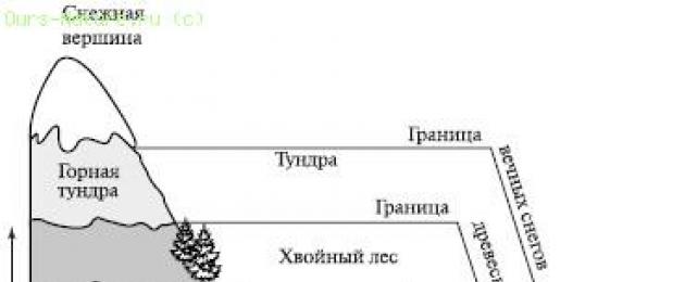
Altitudinal zonality landscapes is due to climate change with height: a decrease in temperature by 0.6 ° C for every 100 m of elevation and an increase in precipitation up to a certain height (up to 2-3 km)5. The change of belts in the mountains occurs in the same sequence as on the plains when moving from the equator to the poles. However, in the mountains there is a special belt of subalpine and alpine meadows, which is not found on the plains. The number of altitudinal belts depends on the height of the mountains and their features. geographical location. The higher the mountains and the closer they are to the equator, the richer their range (set) of altitudinal belts. The range of altitudinal belts in the mountains is also determined by the location of the mountain system relative to the ocean. In the mountains located near the ocean, a set of forest belts predominates; in the intracontinental (arid) sectors of the continents, treeless altitudinal belts are characteristic.
6. Physical-geographical zoning as one of the most important problems of physical geography. System of taxonomic units in physical geography
Zoning as a universal method of ordering and systematizing territorial systems is widely used in the geographical sciences. The objects of physical-geographical, otherwise landscape, zoning are specific (individual) geosystems of the regional level, or physical-geographical regions. A physical-geographical region is a complex system that has territorial integrity and internal unity, which is due to the common geographical location and historical development, the unity of geographical processes and conjugation constituent parts, i.e. subordinate geosystems of the lowest rank.
Physical-geographical regions are integral territorial arrays, expressed on the map by one contour and having their own names; when classifying, one group (type, class, species) can include landscapes that are territorially separated; on the map they are more often represented by broken contours.
Each physical-geographical region represents a link in a complex hierarchical system, being a structural unit of regions of higher ranks and an integration of geosystems of lower ranks.
Physical-geographical zoning has a significant practical value and finds application for integrated accounting and evaluation natural resources, when developing plans for the territorial development of the economy, large reclamation projects, etc.
Regionalization guides focus on the system of taxonomic units. This system is preceded by a list of principles that should serve as the basis for diagnosing regions. Among them, the principles of objectivity, territorial integrity, complexity, homogeneity, genetic unity, and a combination of zonal and azonal factors are most often mentioned.
The formation of physical-geographical regions is a long process. Each region is a product of historical (paleogeographical) development, during which the interaction of various area-forming factors took place and their ratio could repeatedly change.
We can speak of two primary and independent series of physical-geographical regions - zonal and azonal. The logical subordination between regional taxa of different ranks exists separately within each series.
All known schemes of physical-geographical zoning are built according to the two-row principle, since zonal and azonal units are distinguished independently.
It is possible to distinguish three main levels of zoning depending on its detail, i.e. from the final (lower) stage:
1) the first level includes countries, zones and closes on derivative zones in the narrow sense of the word;
2) the second level includes, in addition to the listed levels, regions, subzones and units derived from them, ending with a subprovince;
3) the third level covers the entire system of subdivisions up to and including the landscape.
Conclusion
Thus, the geographical shell should be understood as a continuous shell of the Earth, which includes the lower layers of the atmosphere, the upper part of the lithosphere, the entire hydrosphere and biosphere, which are in contact, interpenetration and interaction. We emphasize once again that the geographic shell is the planetary (largest) natural complex.
Many scientists believe that the thickness of the geographic shell is on average 55 km. Compared to the size of the Earth, this is a thin film.
The geographic envelope has the most important properties inherent only to it:
a) it has life (living organisms);
b) substances are in it in a solid, liquid and gaseous state;
c) it exists and develops human society;
d) it has general patterns of development.
The integrity of the geographic envelope is the interconnection and interdependence of its components. The proof of integrity is a simple fact - a change in at least one component inevitably entails a change in others.
All components of the geographic shell are connected into a single whole through the circulation of substances and energy, due to which the exchange between the shells (spheres) is also carried out. Rhythm is characteristic of animate and inanimate nature. Mankind, perhaps, has not fully studied the rhythm of the geographical shell.
The issues raised in the introduction are considered, the purpose of the work is achieved.
Bibliography
Grigoriev A. A. Experience of the analytical characteristics of the composition and structure of the physical-geographical shell of the globe - M .: 1997 - 687p.
Kalesnik S. V. General geographical patterns of the Earth. - M.: 1970 - 485s.
Parmuzin Yu.P., Karpov G.V. Dictionary of physical geography. - M.: Enlightenment, 2003 - 367 p.
Ryabchikov A. M. Structure and dynamics of the geosphere, its natural development and change by man. -M.: 2001.- 564s.
Physical geography of continents and oceans: Tutorial/ Ed. A.M. Ryabchikov. - M.: graduate School, 2002.- 592 p.
Where are the boundaries between the plates of the lithosphere? a) along ravines; b) on plains and rivers; c) along mid-ocean ridges and deep-sea trenches; d) alongcoastline of the continents. What are the ancient stable areas of lithospheric plates called? a) folded areas; b) platforms; c) plains; d) the bed of the ocean. What is the name of the long-term weather regime that repeats in a given area from year to year? a) climate; b) the weather; c) isotherm; d) the greenhouse effect. The closer to the equator, the: a) the greater the angle of incidence of the sun's rays and the less the earth's surface heats up b) the smaller the angle of incidence of the sun's rays and the higher the air temperature in the troposphere) the greater the angle of incidence of the sun's rays and the earth's surface heats up more, which means , the air temperature in the surface layer of the atmosphere is higher d) the angle of incidence of the sun's rays is less and the earth's surface heats up less. What winds prevail in tropical latitudes? a) trade winds; b) Western; c) northern; d) monsoons. Where are areas of low pressure on Earth? a) near the equator and in temperate latitudes; b) in temperate and tropical latitudes c) near the poles; d) only over the continents. At what latitudes is the upward movement of air observed? a) in the tropical; b) in the equatorial; c) in the Antarctic; d) in the arctic. In which climatic zone do 2 air masses dominate during the year: temperate and tropical? a) in temperate; b) in the tropics; c) in the subtropical; d) in the subequatorial. For which climate. belts are characterized by the dominance of westerly winds, pronounced seasons? a) for the tropical; b) for the equatorial; c) for moderate; d) for the Arctic. What does the salinity of ocean waters depend on? a) on the amount of precipitation; b) from evaporation; c) from the inflow of river waters; d) from all of the above reasons. The temperature of surface ocean waters: a) is the same everywhere; b) varies and depends on latitude; c) changes only with depth; d) changes with depth and with latitude. What causes the alternation of natural zones on land? a) the amount of moisture; b) the amount of heat; c) vegetation; d) the ratio of heat and moisture. Part B. What are the three layers that make up the continental crust? What is the importance of the atmosphere for living organisms? (at least 3 factors) Indicate, thanks to which all components of the geographical envelope are connected into a single whole? Define the concept of race, and indicate the main human races. Part C. What force moves the plates of the lithosphere? Why do air masses move during the year to the north, then to the south? What is altitudinal zonality? And its main pattern.
A) equatorial
B) tropical
C) moderate
D) Arctic
E) Antarctic
2. Changing one component of nature entails
A) an increase in the depths of the ocean
B) an increase in the heights of mountains
C) reduction of platform areas
D) change in the speed of river flow
E) change in the natural complex
3. The main components of the natural complex are
A) animals, plants, people
C) relief, rocks, climate, water
C) weather conditions, the activity of organisms
D) glaciers, seas, oceans
E) lakes, rivers, swamps
4. Organisms that are oxygen factories
A) plankton
B) Plants
C) Microorganisms
D) Pisces
E) Animals
5. Plexus and combination of natural components forms
A) thermal belt
B) area
C) Climate zone
D) Natural complex
E) Natural belt
6. An example of a natural natural complex is
What about the town
B) swamp
C) arable land
D) Park
E) Reservoir
7. Complex shell of the earth
A) lithosphere
B) thermosphere
C) atmosphere
D) Hydrosphere
E) Geographical envelope
8. The name of the natural area is given by
A) the animal kingdom
B) Vegetation
C) soil
D) Rocks
E) climate
9. An example of the manifestation of rhythm in a geographical envelope is
A) cooling and warming
B) biological cycle
C) With improper farming - desertification of soils
D) Air circulation
E) Soil salinization due to the drainage of swamps
10. The regularity of the geographical shell, which is characterized by a close relationship of its constituent parts, is
A) rhythm
B) integrity
C) zoning
D) climate
E) the circulation of matter and energy
- In contact with 0
- Google+ 0
- OK 0
- Facebook 0